News
News list
-
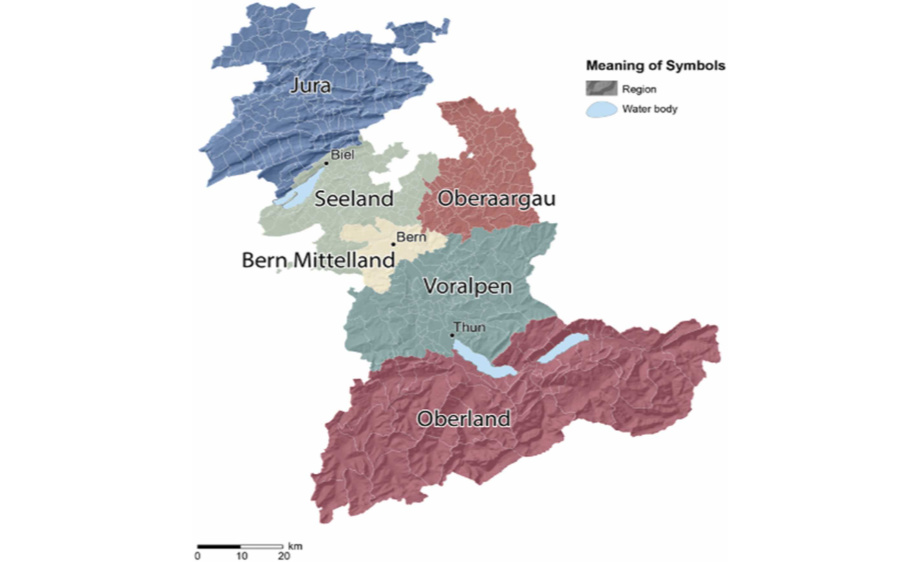
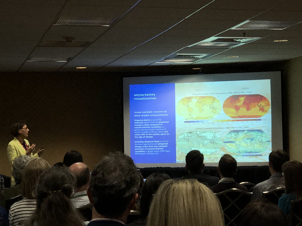
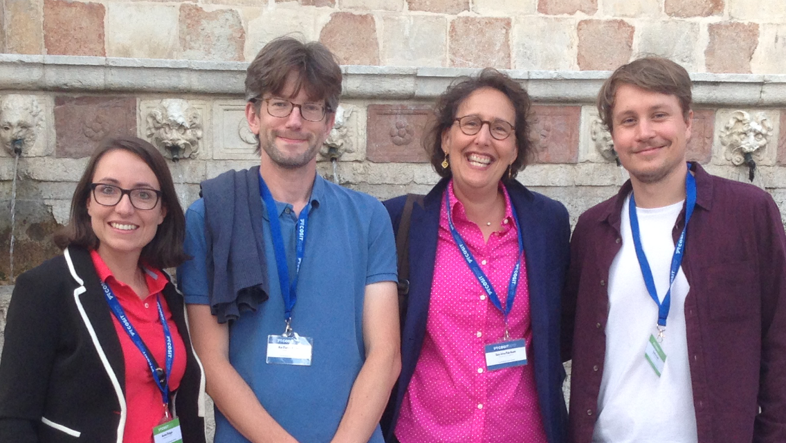
GIVA@EGU 2026, Vienna, Austria
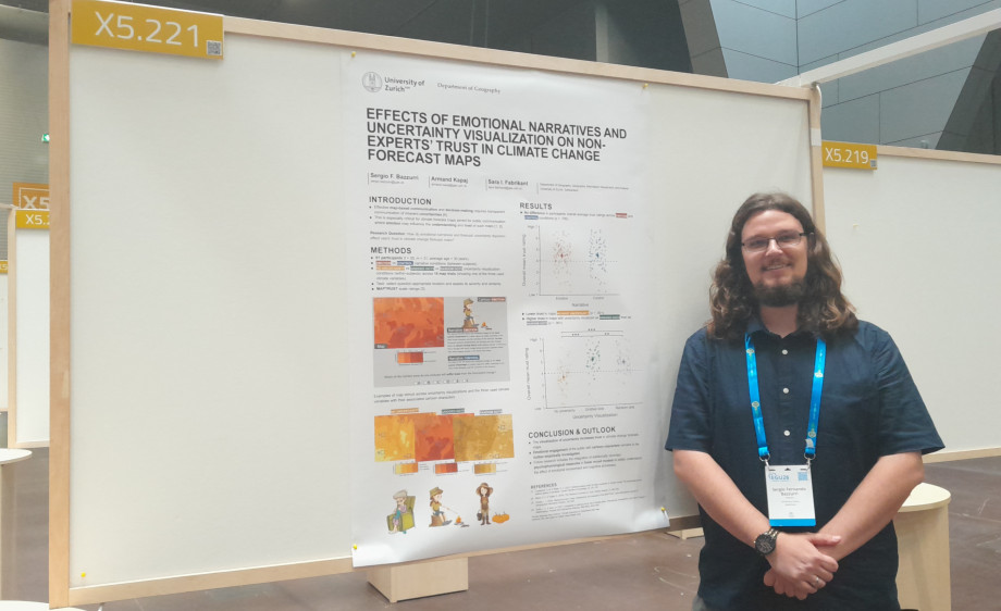
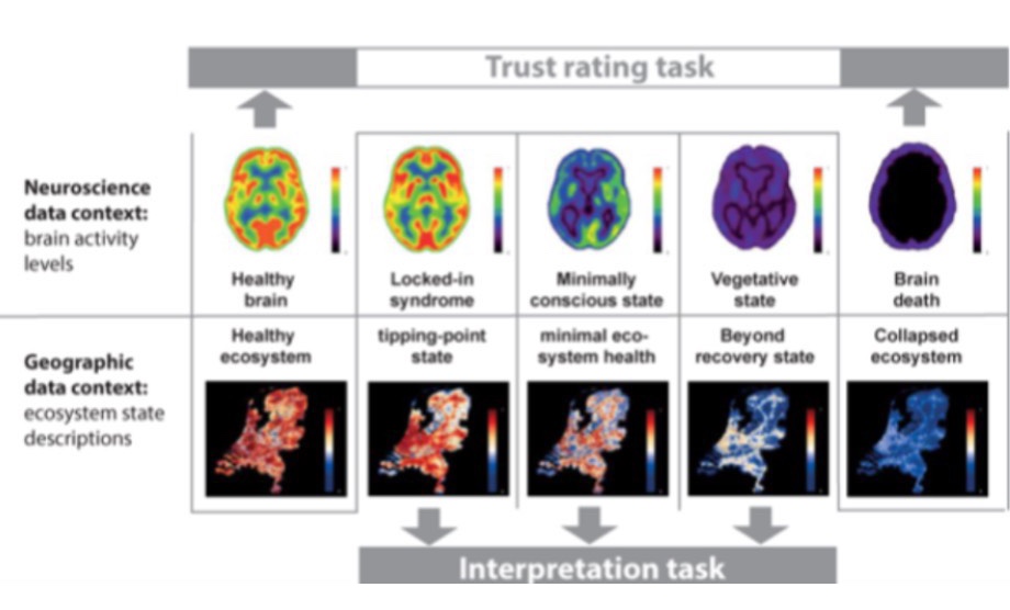
Sergio Bazzurri participated at the European Geoscience Union General Assembly 2026 (EGU26), taking place in Vienna, Austria from May, 3-8 2026.
He presented the poster "Effects of emotional narratives and uncertainty visualization on non-experts’ trust in climate change forecast maps," co-authored with Armand Kapaj and Sara Fabrikant.
-
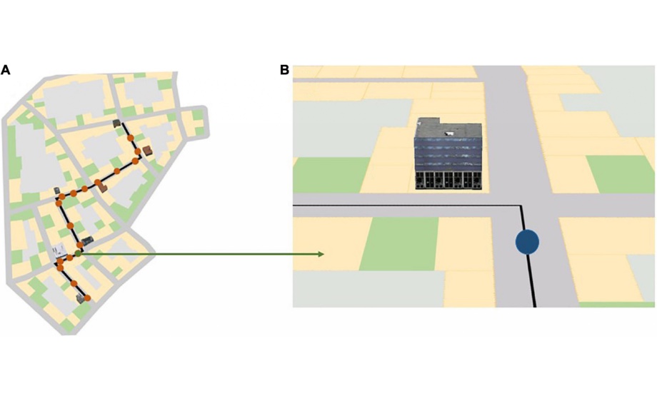
.jpg)
SGAG Prize for Sebastian Quinten
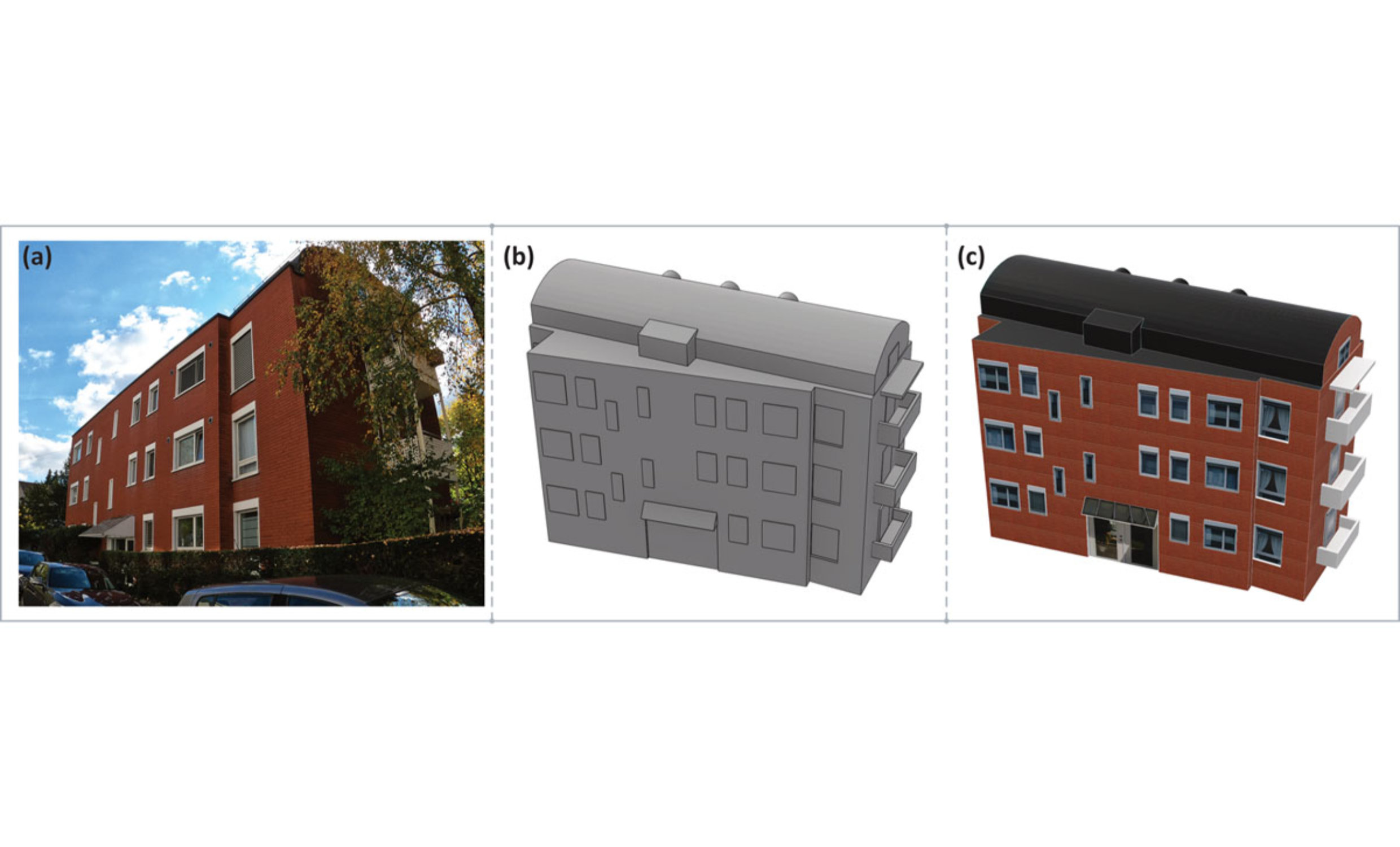
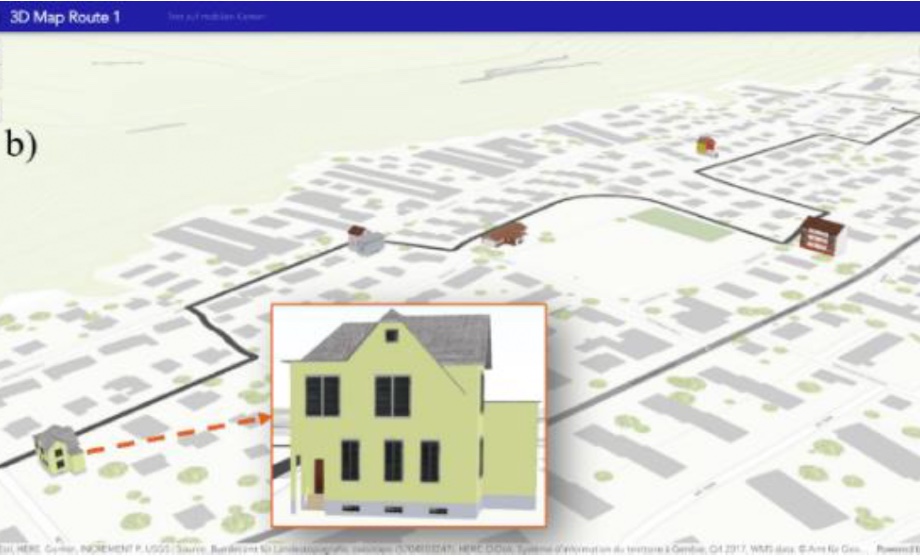
Our MSc graduate Sebastian Quinten achieved 2nd place for his empirical Master's thesis "Emotional Impact of Façade Colors and Materials: A Virtual Reality Study in Rural Switzerland" from the Swiss Society for Applied Geography (SGAG), honoring specifically transdisziplinary Masters theses.
-
SGAG Prize for Claude Widmer
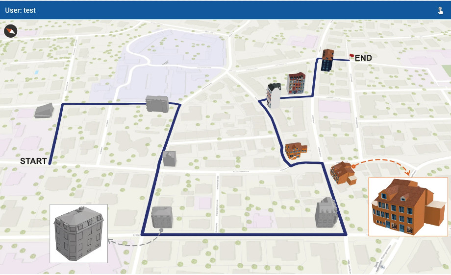
Our MSc graduate Claude Widmer achieved 1st place for his Master's thesis A Computer Vision Framework for Automated Evaluation of School Route Safety in Zurich from the Swiss Society for Applied Geography (SGAG). This award honours master's and diploma theses with a strong practical orientation, high degree of innovation and great relevance for action.
-

Esri Young Scholar Award 2026 for Jon Guler
Our MSc graduate Jon Guler has won the Esri Young Scholar Award 2026 for his Master's thesis MyPlaces – An Adaptive Mobile Map Application. Jon Guler will be presenting his work at the Esri User Conference 2026, which takes place from 13 to 17 July 2026 in San Diego, California.
-
New Publication
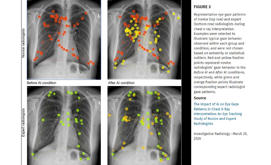
The Impact of AI on Eye Gaze Patterns in Chest X-Ray Interpretation An Eye Tracking Study of Novice and Expert Radiologists
Investigative Radiology
-

New Publication
Do mobile maps help or hinder? Investigating their role in spatial knowledge acquisition across repeated navigation episodes
Journal of Environmental Psychology -
.jpg)
New Publication
Enhancing public transport information visualisation in mobile map apps for hikers
Journal of Location Based Services -

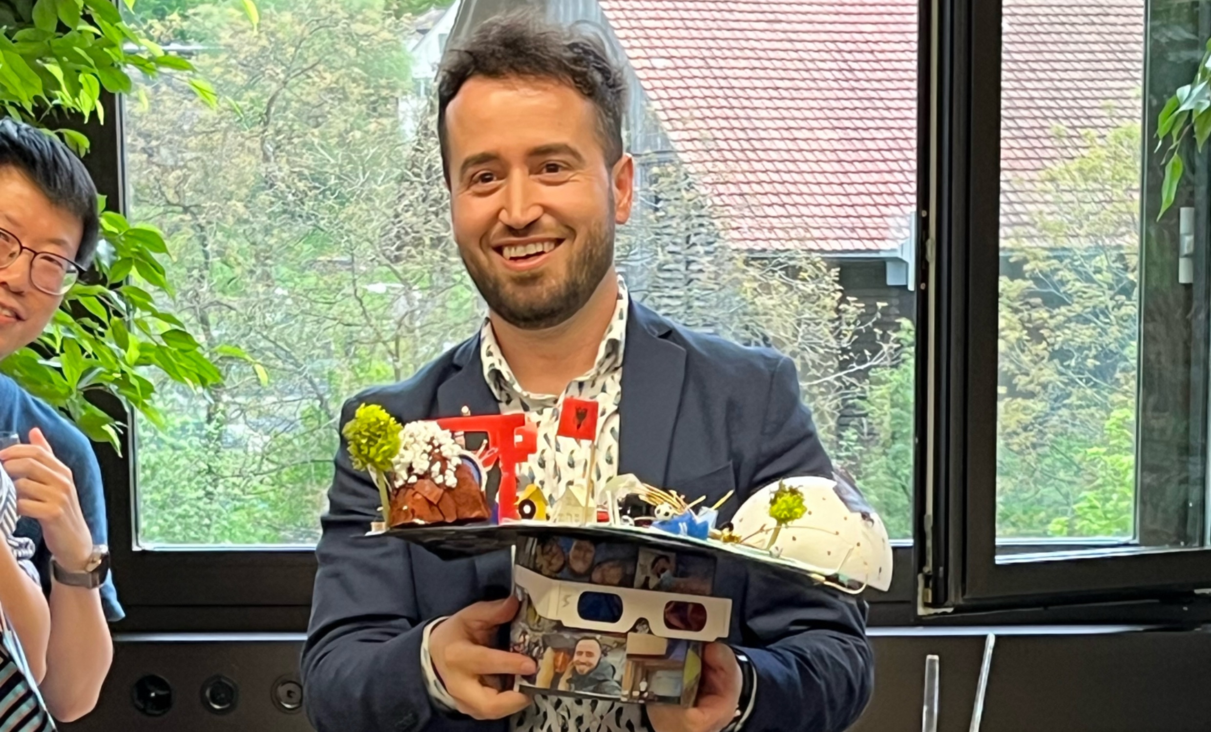
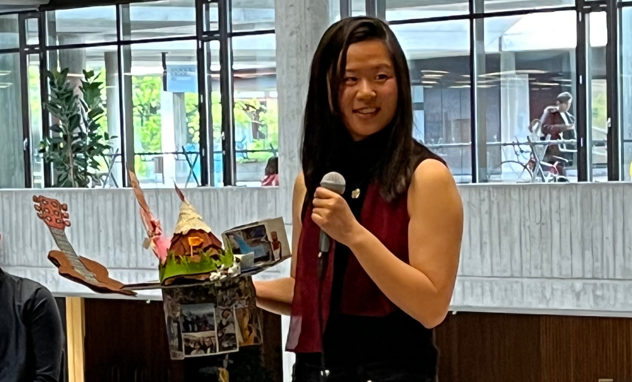
PhD Defense Donatella Zingaro
Heartfelt congratulations and thanks for advancing the GIScience research agenda by "Predicting Mobile Map Interactions with a Context-Enriched Sequential Fusion Model: From Unobtrusive Data Collection to Explainable Models Across Intrinsic, Behavioral, and Extrinsic Contexts".
-

New Publication
Exploring Demand-Responsive Transport Suitability in Rural Switzerland: A Simulation Approach for the Canton of Thurgau
Corrado Muratori, Valerio De Martinis, Stephan Bütikofer
Transportation Research Procedia, Volume 91, 2025, Pages 544-551 -
GIVA organized the ETIZ meet-up
Armand Kapaj and Sara Fabrikant from the GIVA group organized the Eye Tracking Interest Group Zurich (ETIZ) meet-up on October 20, at the Department of Geography of the University of Zurich.
-
.jpg)
GIVA@Cartography M.Sc. Alumni Meeting - Munich, Germany
Armand Kapaj from the GIVA group attended the 15th anniversary of the International Master of Science in Cartography.
-
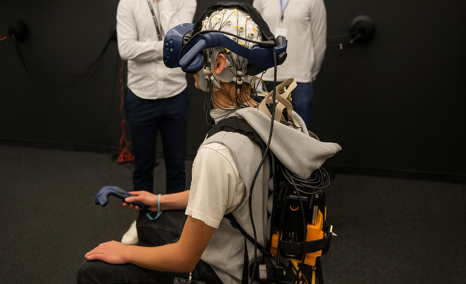
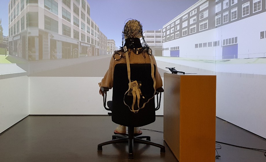
GIVA@MoBI Workshop - Berlin, Germany
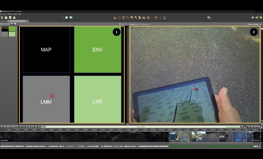
Jiaona Hu and Armand Kapaj from the GIVA group attended the Mobile Brain/Body Imaging (MoBI) workshop from September 30 to October 2, 2025, in Berlin, Germany. The workshop was co-organized by the Brain Products Academy and the Berlin Mobile Brain/Body Imaging Lab (BeMoBIL) at the Chair of Biological Psychology and Neuroergonomics, TU Berlin.
-
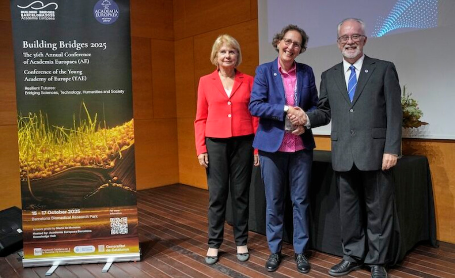
GIVA@AEA 2025 - Barcelona, Spain
Last week Sara Irina Fabrikant and the 2025 cohort of THE ACADEMIA EUROPAEA (THE ACADEMY OF EUROPE) were personally inaugurated at the annual AEA meeting in beautiful Barcelona.
-

GIVA@ICC 2025 - Vancouver, Canada
The 32nd International Cartographic Conference (ICC 2025), with the theme "Mapping the Future: Innovation, Inclusion, and Sustainability", was held in Vancouver, Canada, from August 17-22, 2025. The ICC is a biennial international conference series and brings together researchers, educators, practitioners, and national mapping agencies working in the field of cartography. The GIVA group members attended ICC 2025, where they presented the following work:
-
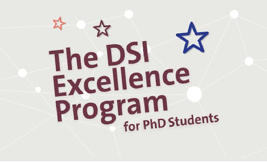
DSI Excellence Program for PhD students
Congratulations to Sergio Bazzurri who has been accepted into the very competitive UZH Digital Society Initiative (DSI) Excellence Program for PhD students!
-
New Publication
Unlocking context-aware mobile map adaptation: a VR navigation user study.
Mona Bartling, Armand Kapaj, Bingjie Cheng, Zhengfang Xu, Amy L. Griffin, & Sara I. Fabrikant
Cartography and Geographic Information Science
-
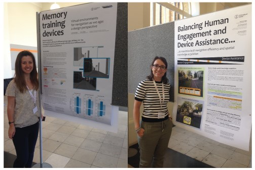
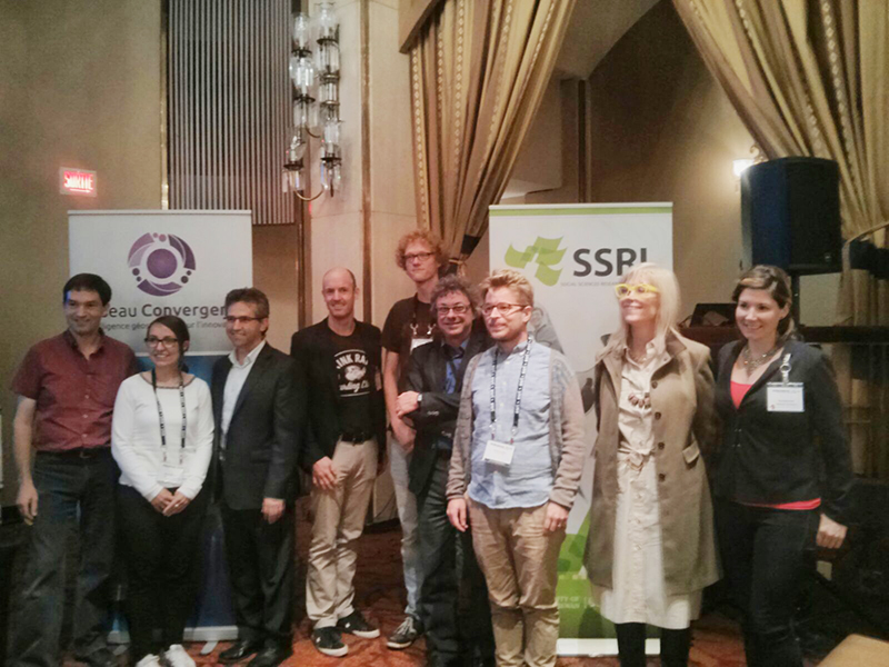
GIVA at AGILE 2025, Dresden, Germany - Best Short Paper Award, Presented Papers, and more!
This year’s 28th AGILE conference (AGILE 2025) was held in Dresden, Germany, June 10-13, 2025, and focused on how Geographic Information Science (GIScience) is responding to Global Challenges. This theme fits the GIVA group’s research vision and mission perfectly, and we presented the following:
-
.jpg)
Open PhD Position – SNFS Project GeoNavLearn
Are you interested in carrying out a PhD? We are happy to invite applications for a doctoral research position in the context of the SNFS Project GeoNavLearn, led by the GIVA group head and PI Sara Irina Fabrikant.
-
GIVA@AGILE2025 - Dresden, Germany
AGILE is the Association of Geographic Information Laboratories in Europe. With over 80 members, it provides a forum for geographic information scientists and educators to meet and exchange ideas. The conference theme, "Geographic Information Science Responding to Global Challenges," highlights the essential contribution of geospatial data and analysis in addressing the critical global issues of our time, from environmental change to human resilience.
-

LBS2025 - Otaniemi, Espoo, Finland
Tumasch Reichenbacher participated at the 19th International Conference on Location Based Services (LBS 2025), taking place at Altho University in Otaniemi, Finland from May, 7-9 2025 (Programme)
-

Election to Academia Europaea
Sara Irina Fabrikant has been elected to the Academia Europaea, a Pan-European Academy of Humanities, Letters and Sciences.
-

4th Schematic Mapping workshop - Paris, France
Invited talk at the 4th Schematic Mapping Workshop, organized by Alain L'Hostis and Valérie Gyselinck from the Université Gustave Eiffel and Simone Morgagni with the SNCF, held at the at École des Ingénieurs de la Ville de Paris, April 10-11, 2025.
-

New Publication
Impact of emotional narratives and personal attitudes towards climate change on map-based decision-making with (un)certainty
Sergio Fernando Bazzurri, Sara Irina Fabrikant
Abstracts of the International Cartographic Association, 9, 37, 2025. -

RIMMA 2025 - Bern, Switzerland
Sergio Bazzurri has been invited to give a presentation on the "Impact of Emotional Narratives and Personal Attitudes Towards Climate Change on Map-based Decision-making with (Un)certainty" at the International Conference on Forecasting, Preparedness, Warning, and Response – RIMMA 202 at the University of Bern on 30 January 2025 (Programme)
-

After years of interruptions, including a health pandemic, the Eye Tracking Interest Group Zurich (ETIZ) meet-up is back!
Qi Ying delivered a presentation titled “Mobile Eye Tracking Outdoors” at the very well attended Eye Tracking Interest Group Zurich (ETIZ) meet-up held at ETH Zentrum on Monday, November 18, 2024, organized by Prof. Christoph Hölscher and colleagues.
-
GIVA @ The Fifth Spatial Data Science Symposium 2024
Together with Profs. Kathleen Stewart (U. Maryland), Meiliu Wu (U. Glasgow), and Simon Scheider (U. Utrecht), Sara Fabrikant shared professional experiences and personal perspectives on the online and distributed early career panel (http://sdss2024.spatial-data-science.net/index.html) lead by the SDSS general chair, Prof. Krzysztof Janowicz and team (U Wien) at the hybrid SDSS24.
-
“Geovisualisation: Interfaces and Interactions” workshop - Paris, France
Invited talk at the workshop “Geovisualisation: Interfaces and Interactions,” organized by the (Carto)graphies et (Géo)visualisation de données research action (AR99 of the GdR CNRS MAGIS), held at the Université Gustave Eiffel, October 4, 2024.
-

GIVA at COSIT 2024, Québec, Canada - Best Poster Award, Presented Papers, and more!
The 16th Conference on Spatial Information Theory (COSIT 2024) was held in Québec City, Canada, from September 17-20, 2024. Established in 1993, COSIT is a biennial international conference series concerned with theoretical aspects of space and spatial information. The GIVA group had extensive participation at COSIT 2024 where group members presented the following work:
-

International Conference on Spatial Cognition (ICSC) - Rome, Italy
The 9th International Conference on Spatial Cognition (ICSC 2024), devoted to “Segmentation and Binding in Spatial Cognition,” was held in Rome from September 9-13, 2024. The GIVA group attended the ICSC and presented the following work:
-

EuroCarto 2024 - Vienna, Austria
Qi Ying has been invited to give a presentation on "Spatial knowledge acquisition in mobile map-assisted navigation: a real-world longitudinal study" at the European Cartographic Conference – EuroCarto 2024, on 10 September 2024 in Vienna (Programme).
-

CartoVis24 - Warsaw, Poland
Tumasch Reichenbacher and Qi Ying have been invited to give a presentation at the ICA Workshop on AI, Geovisualisation, and Analytical Reasoning on 7 September 2024 in Warsaw (Programme)
-

New Publication
Special Issue in Cartography and Geographic Information Science (CaGIS)
A special issue was put together to recognize Prof. Barbara Buttenfield's 35+ years of contributions to Cartography and GIScience. It containis five co-authored articles by her former students, collaborators, and GIScience scholars who were influenced by her work, including GIVA members. -

-

AI in Education, Research and Innovation
DSI Strategy Lab 2023—Position Paper
In times of artificial intelligence, exchange and reflection are likely to take on more importance in teaching. Universities also need to find out which cannot be replaced by AI, according to the Digital Society Initiative at UZH -

New Publication
How Do In-Car Navigation Aids Impair Expert Navigators’ Spatial Learning Ability?
Annals of the American Association of Geographers -
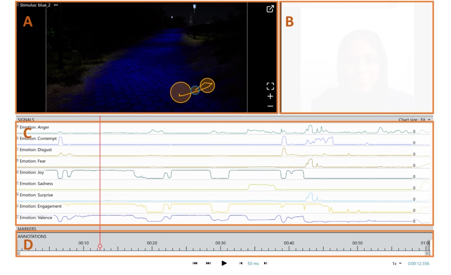
New Publication
The positive effect of blue luminescent pathways on urban park visitor’s affective states: A virtual reality online study measuring facial expressions and self-reports
Urban Analytics and City Science -
New Publication
The influence of landmark visualization style on task performance, visual attention, and spatial learning in a real-world navigation task
Spatial Cognition & Computation -
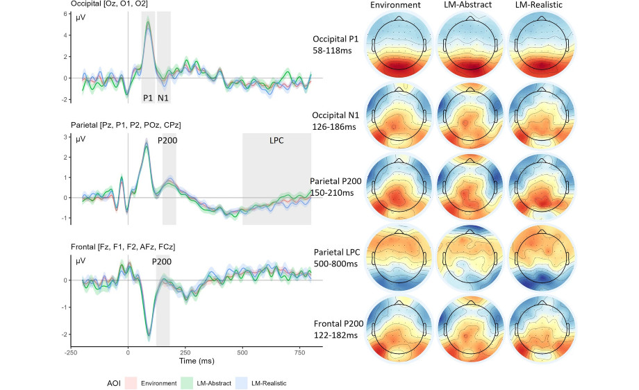
New Publication
Fixation-related potentials during mobile map assisted navigation in the real world: The effect of landmark visualization style
Attention, Perception, & Psychophysics -
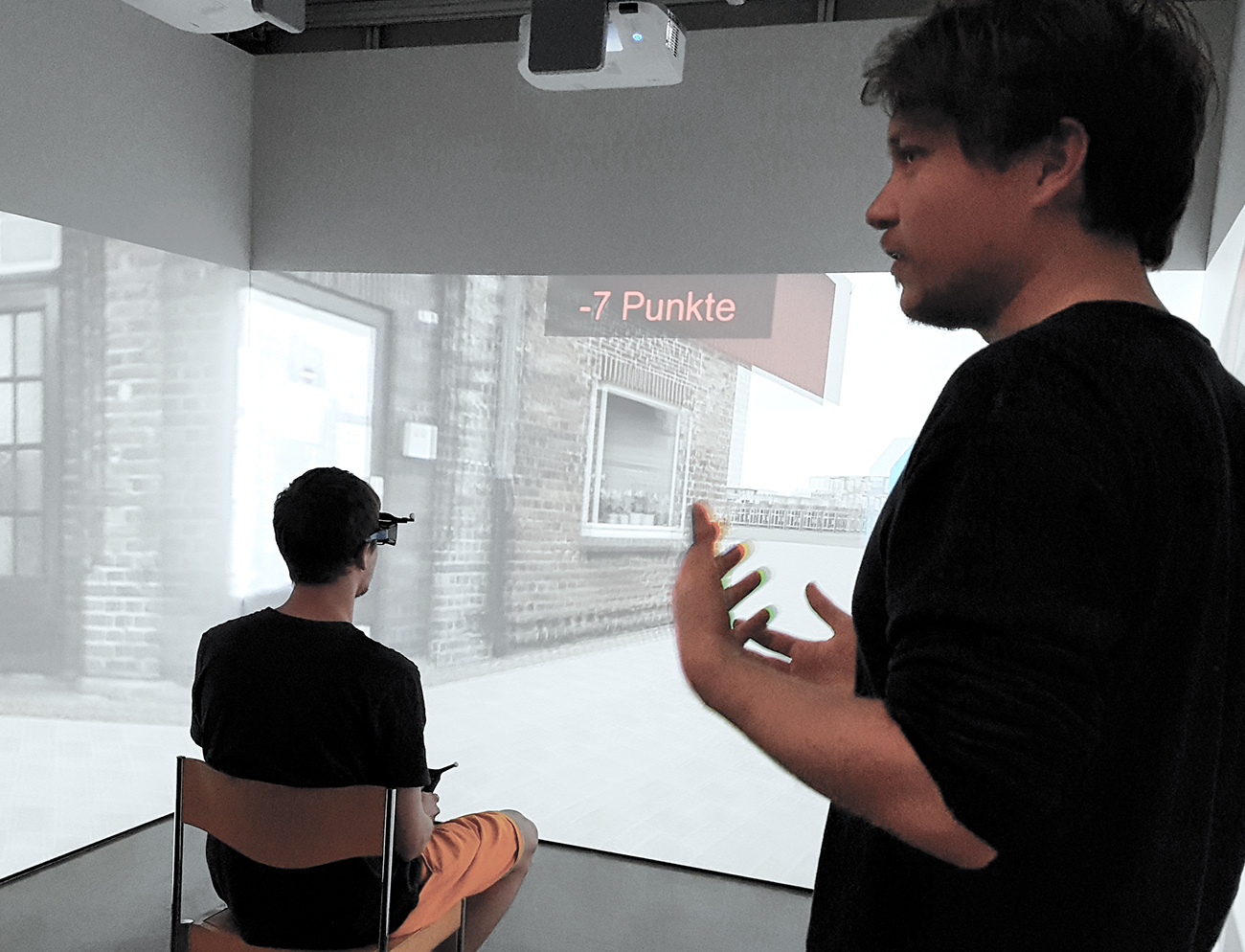
Beyond the blue dot: Try to get lost!
Instead of blindly following Google Maps, we should have a different kind of navigation system that helps us learn from the environment as we go, argues Sara I. Fabrikant. Ahead of her Robert Blumberg Distinguished Lecture in Cognitive Science at the University of Riga, she talked about the intricate interplay between digital navigation tools and human cognition.
-
-
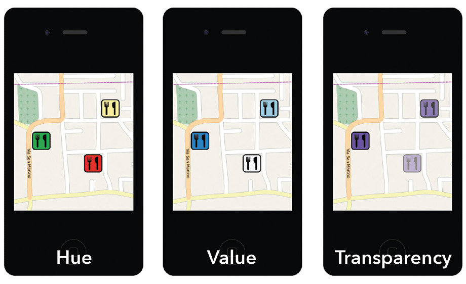
New Publication
A study on the aptitude of color hue, value, and transparency for geographic relevance encoding in mobile maps
Cartography and Geographic Information Science -
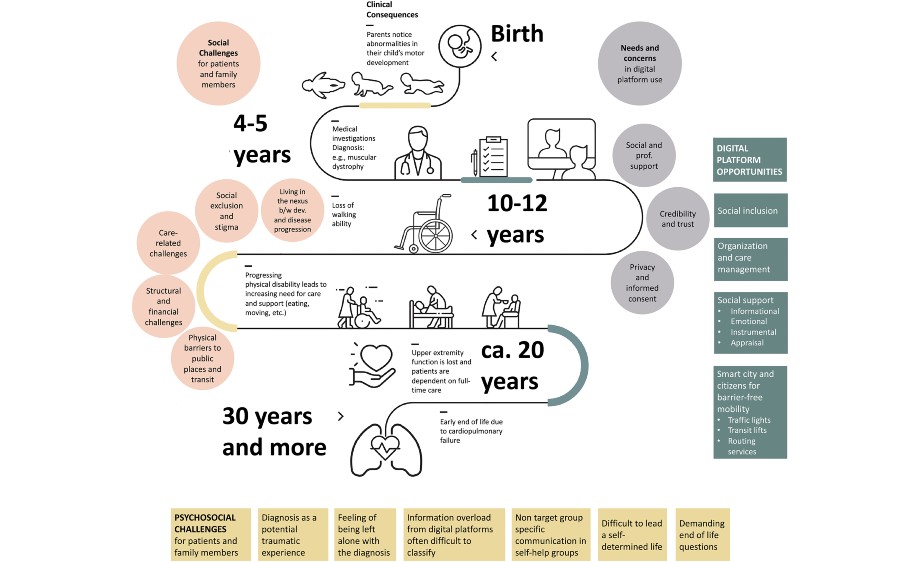
New Publication
Mental health challenges and digital platform opportunities in patients and families affected by pediatric neuromuscular diseases - experiences from Switzerland
DIGITAL HEALTH, Volume 9: 1–11 -
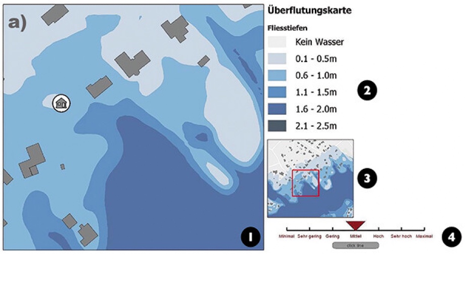
New Publication
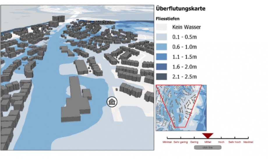
How does your viewing perspective matter for decision-making with flood risk maps?
Cartography and Geographic Information Science -
New Publication
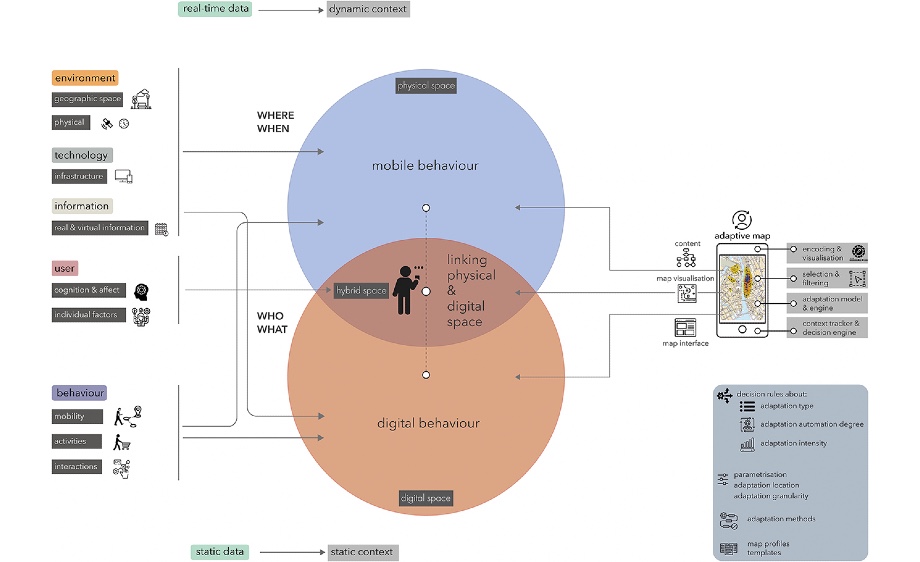
Adaptivity as a key feature of mobile maps in the digital era
Front. Commun. 8:1258851. -
New Publication
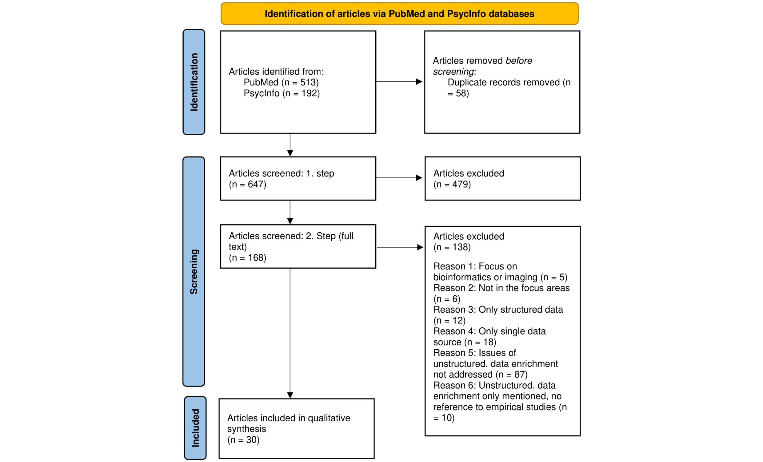
Challenges and best practices for digital unstructured data enrichment in health research: A systematic narrative review
PLOS Digit Health 2 -
The GIVA class of 2023 - Part 2
On October 13, 2023 we celebrated four of GIVA's proud new Masters in Geography: Patrick Luchsinger (left), Sebastian Marti (right) in the picture together with Tumasch Reichenbacher (middle), including Inga Birkhölzer and Stéphanie Wismer who unfortunately could not be found for the picture taking at graduation day. We wish them all the best for the future! This includes congratulatory wishes from afar from Sara Fabrikant, currently on research leave in Tokyo, Japan.
-
New Publication
Limiting the reliance on navigation assistance with navigation instructions containing emotionally salient narratives for confident wayfinding
Journal of Environmental Psychology -
New Publication
A Space-Time Model for Demand in Free-Floating Carsharing Systems
Journal of Advanced Transportation -
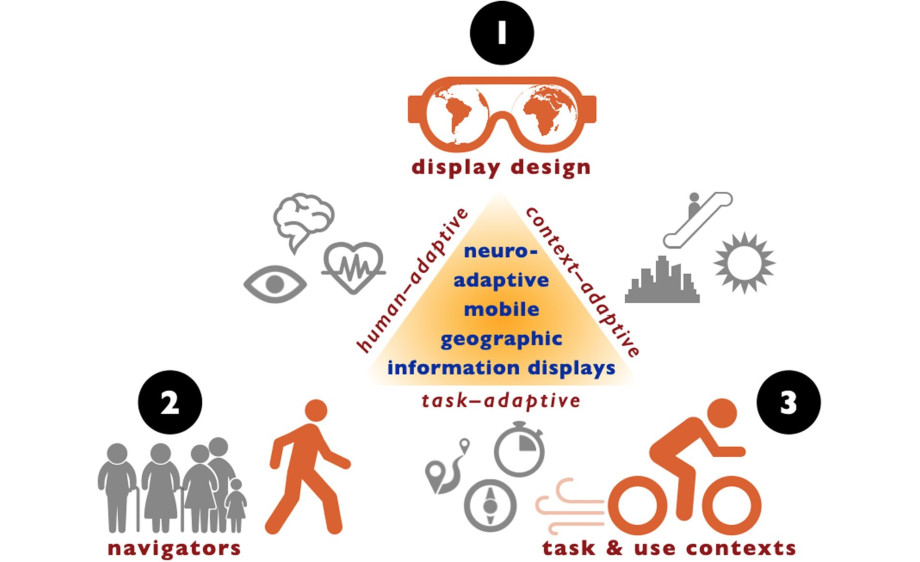
New Publication
Neuroadaptive mobile geographic information displays: an emerging cartographic research frontier
International Journal of Cartography -
DSI Insights
Was bedeutet die Digitalisierung für mobile Karten? Warum sehen sich Kartenapps so ähnlich? Unterstützen sie uns optimal bei unserer Mobilität?
-
New Publication
Neuroadaptive LBS: towards human-, context-, and task-adaptive mobile geographic information displays to support spatial learning for pedestrian navigation
Journal of Location Based Services -
New Publication
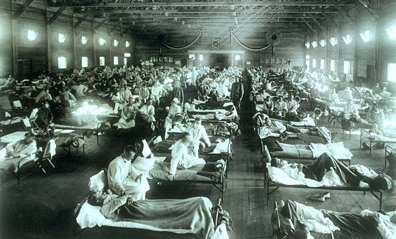
From pandemic to endemic: Spatial-temporal patterns of influenza-like illness incidence in a Swiss canton, 1918–1924
Economics & Human Biology, vol. 50 -

DIZH Podcast
Great fun talking to Frank Richter & Jessica Reust in their brand new DIZH "Schampar Digital" Series on the digital transformation about map assisted navigation, spatial learning, & spatial cognition. https://t.ly/9b69x - Swiss German only.
-
New Publication
Landmark Sequence Learning from Real-World Route Navigation and the Impact of Navigation Aid Visualisation Style
Journal of Cognition, vol. 6(1), no. 41: 1–8 -
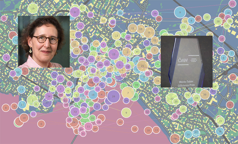
Waldo-Tobler GIScience Prize to Sara I. Fabrikant
For her outstanding and sustained contributions to the discipline worthy of inspiring young scientists in Geoinformatics or Geographic Information Science, and for having accomplished significant advances in research and education.
-
GIVA field trip to Swisstopo
On May 24, GIVA organised a field trip with 25 students from the Bachelor and Master curriculum to Berne. In the morning, we learned how swisstopo collects topographic data and how the maps are produced and printed. Later we had the chance to explore modern geovisualisation tools.
-
PhD Defense Armand Kapaj
Landmark Visualization on Mobile Maps – Effects on Visual Attention, Spatial Learning, and Cognitive Load during Map-Aided Real-World Navigation of Pedestrians
(Fabrikant / Gartner / Lanini-Maggi / Richter / Weibel) -
PhD Defense Bingjie Cheng
Human spatial navigation in the digital era—effects of landmark depiction on mobile maps on navigators’ spatial learning and cognitive load during assisted navigation
(Fabrikant / Gramann / Weibel ) -
New Publication
How does the design of landmarks on a mobile map influence wayfinding experts’ spatial learning during a real-world navigation task?
Cartography and Geographic Information Science -
The GIVA class of 2023
On March 3, 2023 we celebrated four of GIVA's proud Masters in Geography. We wish them all the best for their future!
From left to right: Tumasch Reichenbacher, Nicolas Morf, Florian Sturzenegger, Jana Bracher, Anna-Lena Burren, Sara I. Fabrikant -
New Publication
Using spontaneous eye blink-related brain activity to investigate cognitive load during mobile map-assisted navigation
Frontiers in Neuroscience, Sec. Neural Technology, Volume 17 - 2023 -

UZH Postdoc Team Award
Checking the pulse of society
What can tweets reveal about our mental health? Oliver Grübner explored this question with two colleagues from different disciplines and faculties. Together they have now won the UZH Postdoc Team Award -
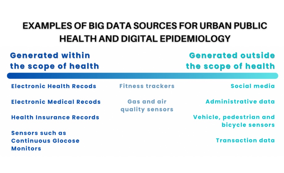
New Publication
Reproducibility and Scientific Integrity of Big Data Research in Urban Public Health and Digital Epidemiology: A Call to Action
Int. J. Environ. Res. Public Health 2023, 20(2), 1473 -
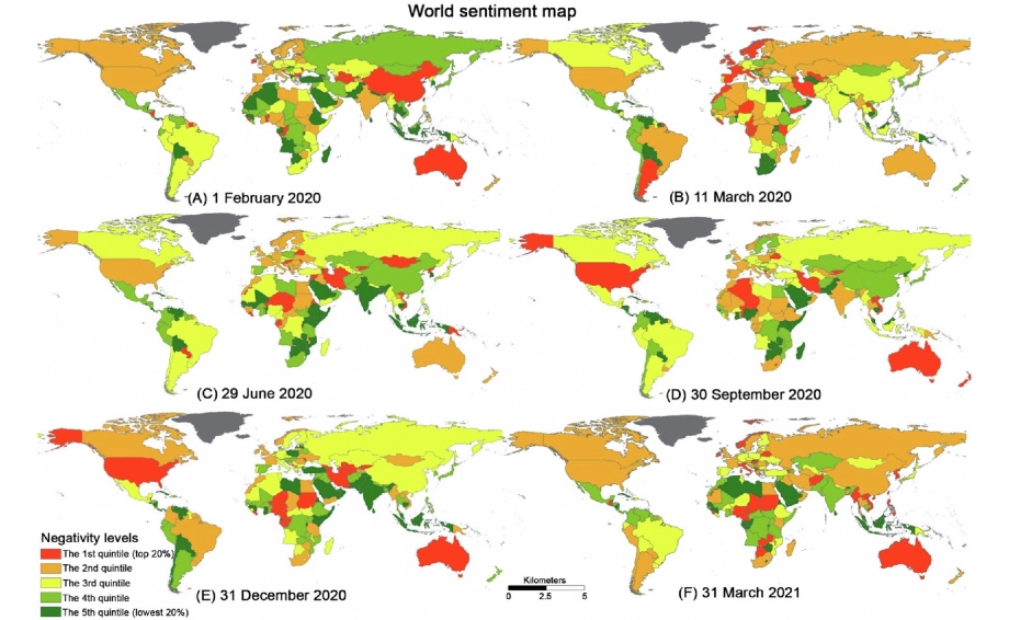
New Publication
A global portrait of expressed mental health signals towards COVID-19 in social media space
International Journal of Applied Earth Observation and Geoinformation
Volume 116, February 2023, 103160 -
Mini Symposium at the IEM
on epidemics, space & inequality – past and present.
The symposium was held at the Institute of Evolutionary Medicine (IEM) organized by PD Dr. Kaspar Staub. -
New Publication
The effect of landmark visualization in mobile maps on brain activity during navigation: A virtual reality study
Front. Virtual Real., 15 November 2022 -

New Publication
Digital platform uses for help and support seeking of parents with children affected by disabilities: A scoping review
J Med Internet Res 2022;0(0):e0) -
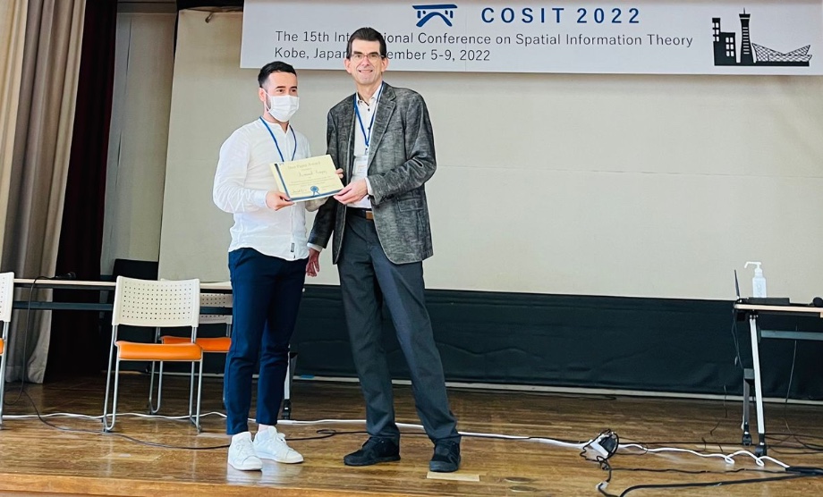
COSIT 2022: Best Short Paper Award
The Effect of Abstract vs. Realistic 3D Visualization on Landmark and Route Knowledge Acquisition
Armand Kapaj got the Award for the "Best Short Paper" at the 15th International Conference on Spatial Information Theory -
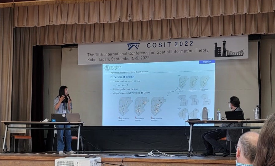
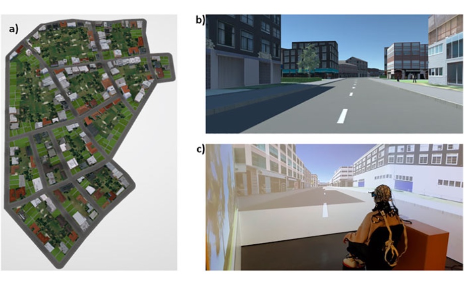
COSIT 2022
Eye Blink-Related Brain Potentials During Landmark-Based Navigation in Virtual Reality
Bingjie Cheng presented the research work on eye blink-related brain potentials during landmark-based navigation in virtual reality at the COSIT 2022 in Kobe. -
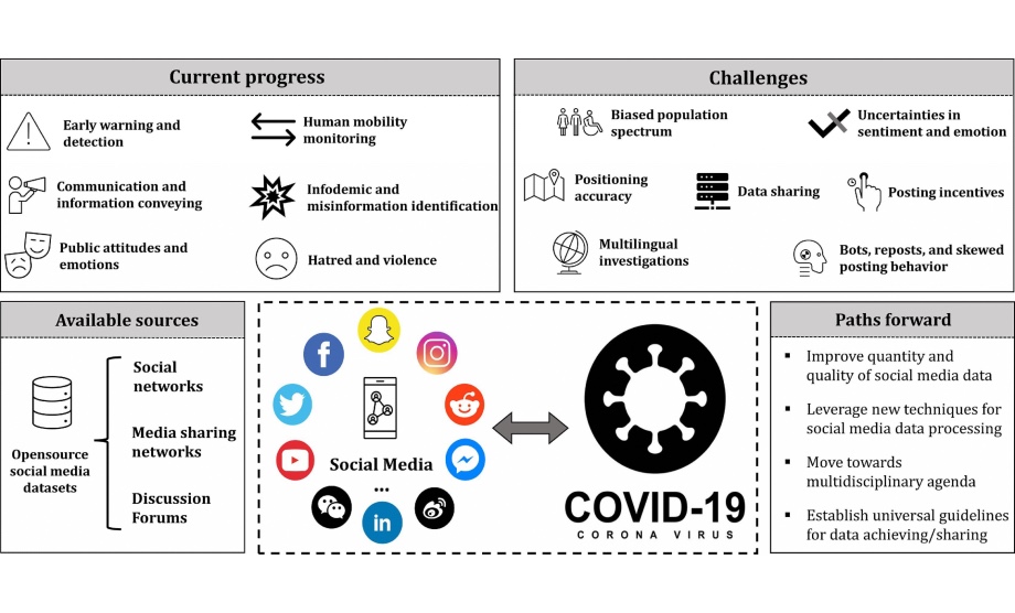
New Publication
Social media mining under the COVID-19 context: Progress, challenges, and opportunities
International Journal of Applied Earth Observation and Geoinformation -
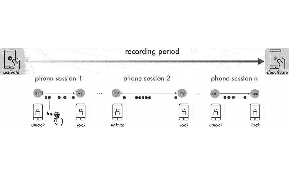
New Publication
Tappigraphy: continuous ambulatory assessment and analysis of in-situ map app use behaviour
Journal of Location Based Services -
New Publication
Opportunities and challenges of using social media big data to assess mental health consequences of the COVID‑19 crisis and future major events
Discover Mental Health -
New Publication
Virtual Reality as a Tool for Political Decision-Making? An Empirical Study on the Power of Immersive Images on Voting Behavior
Frontiers in Communication -
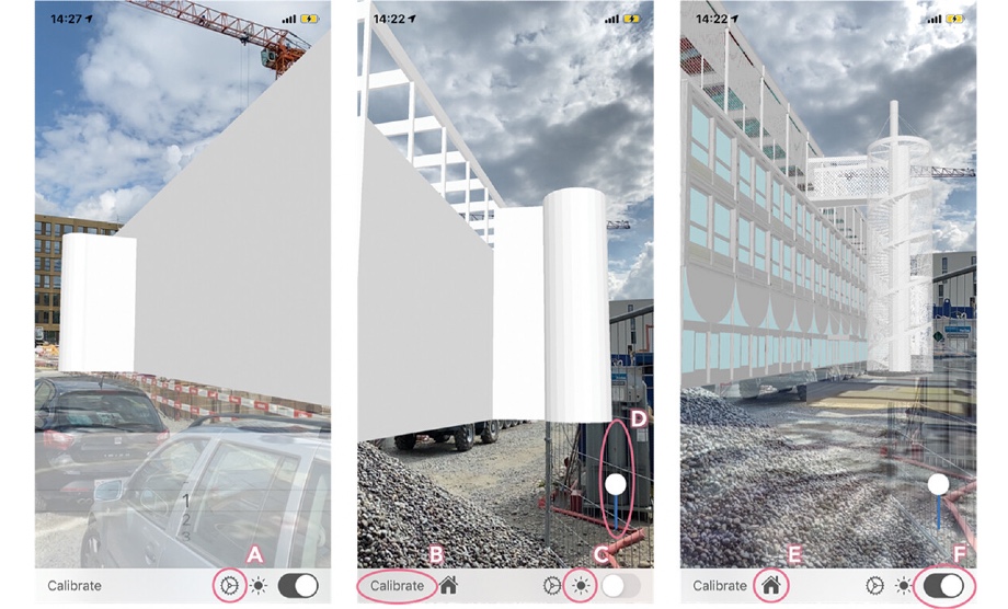
New Publication
An augmented reality study for public participation in urban planning
Journal of Location Based Services -

New Publication
Mental Health and Treatment Considerations for Urban Populations
Comprehensive Clinical Psychology (2nd Edition), Volume 9, 2022, Pages 291-303 -
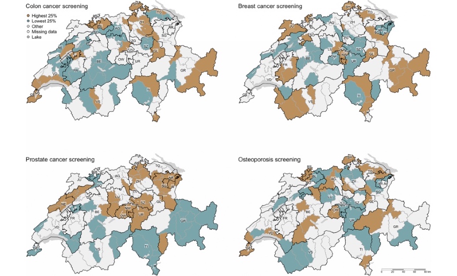
New Publication
Small Area Variation of Adherence to Clinical Recommendations: An Example from Switzerland
SAGE
https://doi.org/ -
New Publication
Detecting Suicide Ideation in the Era of Social Media: The Population Neuroscience Perspective
Front. Psychiatry
https://doi.org/ -
New Publication
Ethical issues of collecting, storing, and analyzing geo-referenced tweets for mental health research
Digital Health
https://doi.org/ -
New Publication
Adapting mobile map application designs to map use context: a review and call for action on potential future research themes
Cartography and Geographic Information Science
https://doi.org/ -
ICC Conference 2021
The impact of landmark visualization style on expert wayfinder’s cognitive load during navigation.
Abstracts of the International Cartographic Association 2021, International Cartographic Conference, Dec. 14-18, 20201, Florence, Italy, -
ICC Conference 2021
Take that Flood: Does your Perspective Matter?
Abstracts of the International Cartographic Association 2021, International Cartographic Conference, Dec. 14-18, 20201, Florence, Italy, -

CRAN - Package fca
Perform various floating catchment area methods to calculate a spatial accessibility index (SPAI) for demand point data. The distance matrix used for weighting is normalized in a preprocessing step using common functions. https://cran.r-project.org/
-

Capturing mood and affective states via Twitter
The coronavirus primarily affects our bodies, but it also has massive impact on our mental health. GIUZ researchers use Twitter content to detect emotional stress related to the COVID-19 pandemic.
-
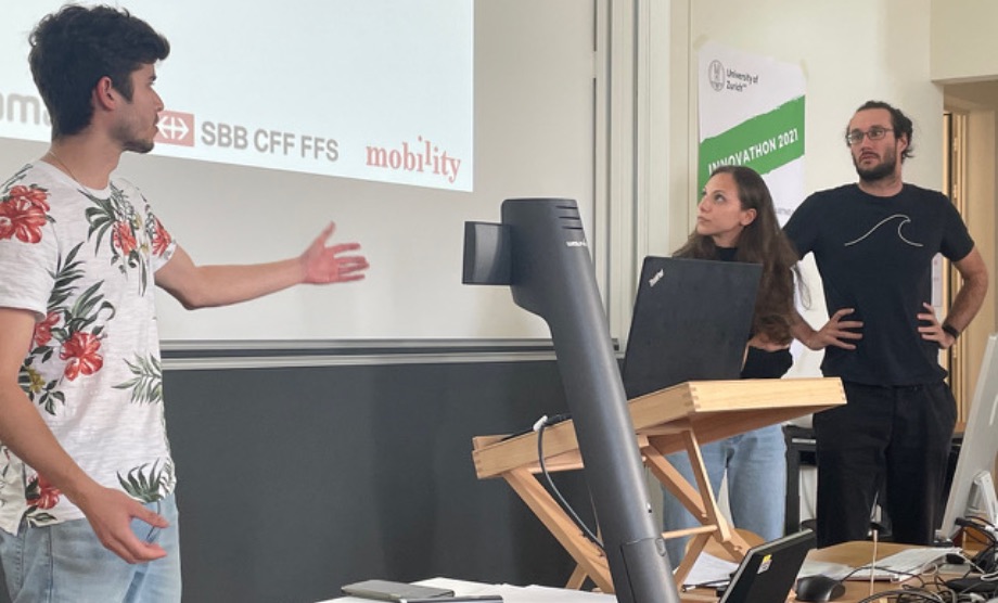
Innovathon, Sep 30 - Oct 2, 2021
From September 30 – October 2, 2021 the DSI Community Mobility and UZH Innovation Hub organised the Innovathon 2021: The Digitalization of Mobility
-
GIScience Conference 2021
On September 29, 2021 Dr. Sara Lanini-Maggi with Dr. Ian Ruginski and Prof. Dr. Sara Fabrikant presented their research on emotional navigation instructions and their impact on spatial learning and map use while navigating unfamiliar environments at GIScience conference:
-
GIScience Conference 2021
The influence of landmark visualization style on expert wayfinders’ visual attention during a real-world navigation task.
11th International Conference on Geographic Information Science, Sep. 27–30, 2020/1, Poznan, Poland. -
New Publication
Modeling Patterns in Map Use Contexts and Mobile Map Design Usability
ISPRS Int. J. Geo-Inf.
https://doi.org/ -
ICC 2021
Effect of cognitive load on spatial learning during navigation: a virtual reality study
International Neuroergonomics Conference 2021, Sep. 11-15, 2021.
Ludwig-Maximilians-Universität Fakultät für Mathematik -
Scientifica, September 4-5, 2021
How will navigation systems of the future make us smarter?
When we move through a city today, we often focus more on our smartphone screen than on the road while finding our way. Does this mean we're losing the important ability to orientate ourselves? -
New Publication
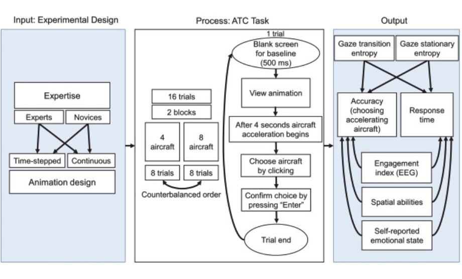
Assessing how visual search entropy and engagement predict performance in a multiple-objects tracking air traffic control task
Elsevier
https://doi.org/ -
New Publication
Toward flexible visual analytics augmented through smooth display transitions
Visual Informatics
https://doi.org/ -
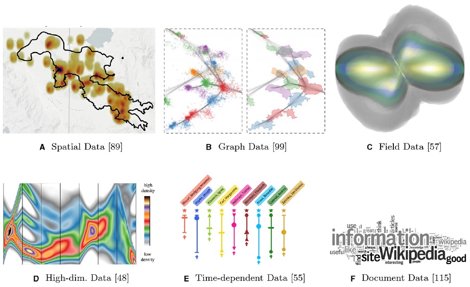
.jpg)
New Publication
Real-time geospatial surveillance of localized emotional stress responses to COVID-19: a proof of concept analysis
Health and Place
https://doi.org
givauzh.shinyapps.io/NYC_tweets/ -
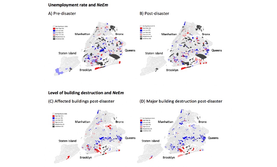
New Publication
Space-Time Dependence of Emotions on Twitter after a Natural Disaster
Int. J. Environ. Res. Public Health
https://doi.org -
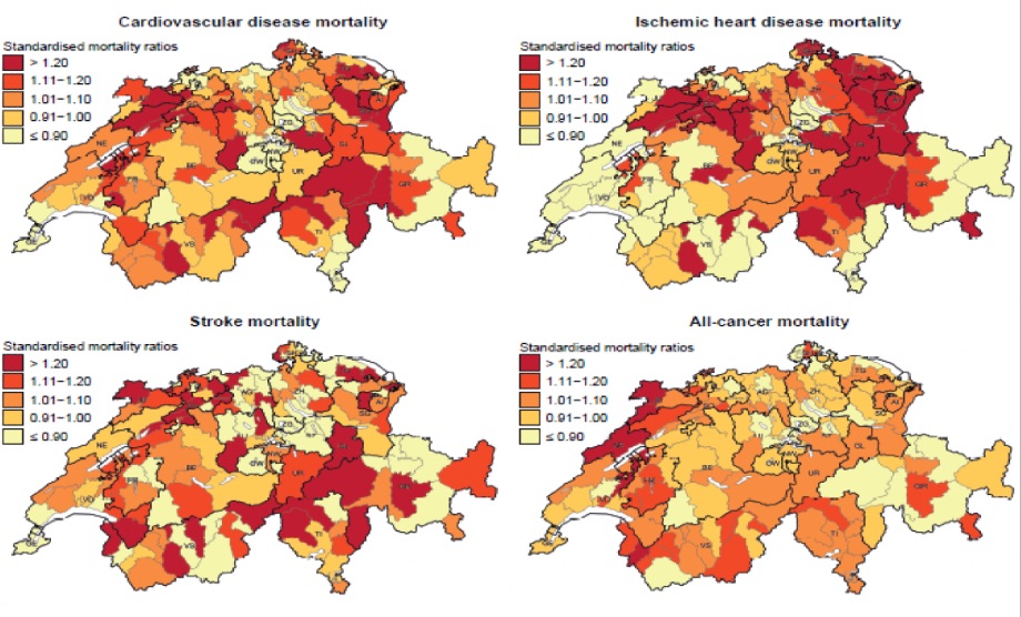
New Publication
Does diet map with mortality? Ecological association of dietary patterns with chronic disease mortality and its spatial dependence in Switzerland
British Journal of Nutrition
https://doi.org -

New Publication
Harm Avoidance and Mobility During Middle Childhood and Adolescence among Hadza Foragers
Human Nature (2021) 32:150–176
https://doi.org -
New Publication
Can Big Data Be Used to Monitor the Mental Health Consequences of COVID-19?
Int J Public Health
> More Information -
SRF: Swisstopo
Geografische Daten der Schweiz für alle verfügbar
Tagesschau vom 21.03.2021
> More Information -
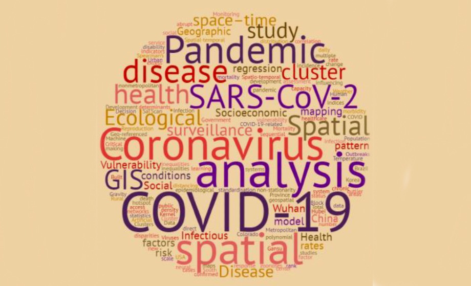
New Publication
Geospatial Analysis of COVID-19: A Scoping Review
Munazza Fatima 1, Kara J. O’Keefe, WenjiaWei, Sana Arshad and Oliver Gruebner
Int. J. Environ. Res. Public Health
> More Information -
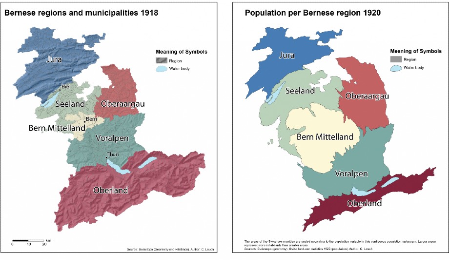
New Publication
Public Health Interventions, Epidemic Growth, and Regional Variation of the 1918 Influenza Pandemic Outbreak in a Swiss Canton and Its Greater Regions
Annals of Internal Medicine
> More Information
> Press Release UZH -
New Publication
Susceptibility of domain experts to color manipulation indicate a need for design principles in data visualization
Markus Christen, Peter Brugger, Sara Irina Fabrikant
PLOS ONE
> More Information -
Ist das Navi in der Hand der erste Schritt zum betreuten Wohnen?
Unser Gehirn ist wie ein Muskel. Wir müssen es benutzen, damit es leistungsfähig bleibt. Je mehr wir Navigationssysteme nutzen, desto schlechter können wir uns selbständig in der Welt zurechtfinden.
> More Information -
"The Eyes Have It!" - Where we look while navigating
How do you navigate to a place you have never been to before? Do you look for clues in the environment, or do you follow the blue dot on your navigation system? Landmarks help us to learn the layout of a traveled space.
> More Information -
«I see and I remember. I do and I understand.»
What if you could immerse yourself and experience a future transport system in a realistic looking virtual environment through your VR goggles, instead of reading about it in a printed booklet before casting your vote?
> More Information -
Numbed by navigation technologies: How can we counteract?
Do you remember how to get to your favorite coffee shop? What is the shortest path to your best friend's apartment? For this you need to rely on your navigation and spatial learning abilities.
> More Information -
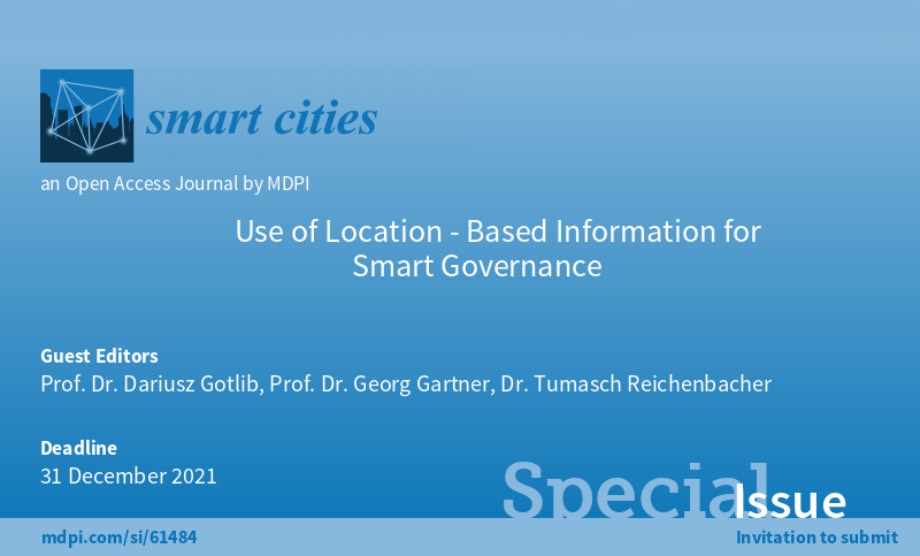
Use of Location-Based Information for Smart Governance
Guest Editors: Prof. Dr. Dariusz Gotlib, Prof. Dr. Georg Gartner, Dr. Tumasch Reichenbacher
The Smart Cities journal is currently looking for submissions to a special issue on 'Use of Location-Based Information for Smart Governance‘
> More information -
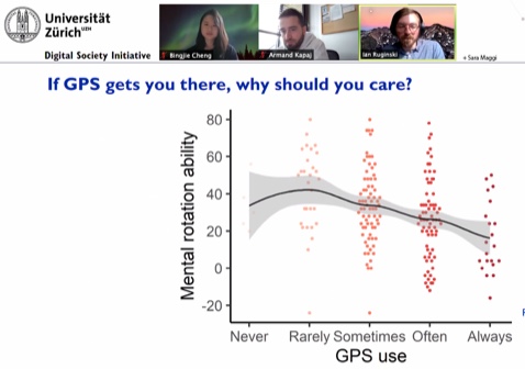
How do we get there? Adaptive and effective design of mobile navigation assistance devices
Dr. Ian T. Ruginski, Bingjie Cheng, Armand Kapaj, Department of Geography, University of Zurich
Millions of international citizens make decisions with and navigate using mobile phones, as GPS-enabled smartphone devices have become increasingly available to the general public. -

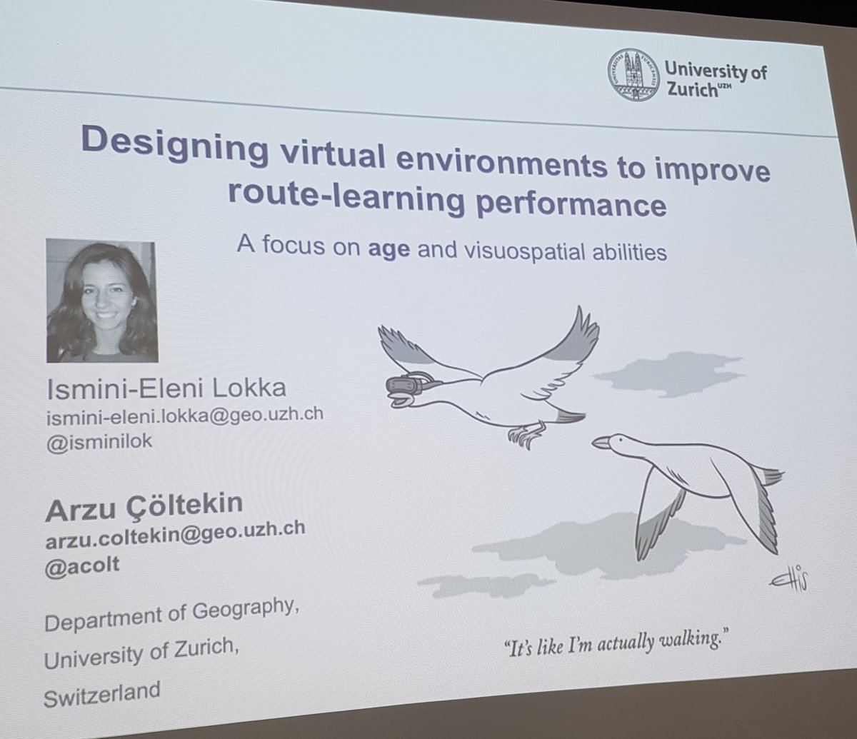
Defense Lokka Ismini
The Impact of 3D Virtual Environments with Different Levels of Realism on Route Learning: A Focus on Age-Based Differences
(Çöltekin / Fabrikant / Weibel / Wiener) -
Defense Brügger Annina
Walk and Learn: Effects of Human-Centered Navigation Systems on Pedestrians’ Navigation Behavior
(Richter / Fabrikant / Weibel)
> EMOtive -
Researching a pandemic - during a pandemic
Last autumn, many people could not quite understand the choice of my Master's thesis topic "The Spanish Flu in the Canton of Berne". Three months and a pandemic outbreak later, however, things are quite different.
> Link Blog -
New Publication
Michelle Korporaal's MSc thesis summarized in the paper "Effects of Uncertainty Visualization on Map-Based Decision Making Under Time Pressure" informs us that uncertainty visualization influences our decision making with maps.
Feel free to check out the paper for other interesting findings.
Congratulations Michelle, Ian, and Sara!
-
GIScience Resilience Panel
> What is resilient GIScience education? For whom and against what?
What is a resilient GIScience educator?
What is a resilient GIScience student?
-
-
New Publication
Prof. Dr. Sara Fabrikant and her co-authors have published an article on "Digital health and the COVID-19 epidemic: an assessment framework for apps from an epidemiological and legal perspective" in Swiss Medical Weekly. Congratulations, Sara!
-
Congratulations to Sascha Credé!
With great pleasure, we announce that Sascha Credé has successfully defended his Ph.D. thesis “The Benefits of Global Landmarks for Spatial Learning under Stress” on November 13th, 2019. GIVA would like to thank him for writing and maintaining the GIVA website for years, and for setting up the experiment participant portal, aside from doing his Ph.D. Congratulations from the GIVA group and every success in your future career!
The picture shows Sascha during the Ph.D. graduation ceremony (from left to right: Dean of Faculty of Science Roland Sigel, Sascha Credé, Sara Irina Fabrikant).
-
New publications
-
GIVA welcomes new staff
GIVA is glad to welcome Dr. Ian Ruginski as new member of the team! Ian is a senior scientist who studies visual perception, navigation, and spatial cognition from an interdisciplinary perspective. He joined us from the University of Utah, where Ian received his PhD in Psychology focusing in Cognition and Neural Science (CNS) and worked as a postdoctoral fellow on the Spatial Cognition and Navigation project. In his empirical work, Ian has investigated different methods of uncertainty visualizations, emotion and spatial learning, and individual differences in spatial cognition. In his recent research, Ian is particularly interested in individual differences in spatial abilities, including how these are affected by geographic information display use.
Ian, we’re thrilled to have you on board !
-
COSIT 2019 in Regensburg
This year, COSIT was held September 9-13 and hosted by the Chair for Information Science in the cosy Bavarian town of Regensburg, Germany. We would like to express our gratitude to the conference organization, to all keynote speakers, presenters, and attendees of COSIT 2019! On the behalf of Tyler Thrash and the international team of researchers, Kai-Florian Richter presented an exciting Vision paper with the title "The future of geographic information displays from GIScience, cartographic, and cognitive science perspectives". In the Doctoral Colloquium, Bingjie Cheng and Armand Kapaj successfully presented their PhD research projects.
Tyler Thrash, Sara Lanini-Maggi, Sara I. Fabrikant, Annina Bruegger, Sascha Crede, Kai-Florian Richter, Cao Tri Do, Haosheng Huang, Stefan Muenzer, Georg Gartner and Sven Bertel. The future of geographic information displays from GIScience, cartographic, and cognitive science perspectives (Vision Paper)
Bingjie Cheng. Enhancing Spatial Learning with an Adaptive Navigation System That Employs Neurofeedback
Armand Kapaj. Landmark Visualization on Mobile Devices for Effective Pedestrian Navigation:Assessing the Effects of Realism for Spatial Learning
-
GIVA @ ECTQG2019
Strong showing of GIVA at the European Colloquium on Theoretical and Quantitative Geography (ECTQG) in Mondorf-Les-Bains, Luxembourg on 5-9 September 2019.
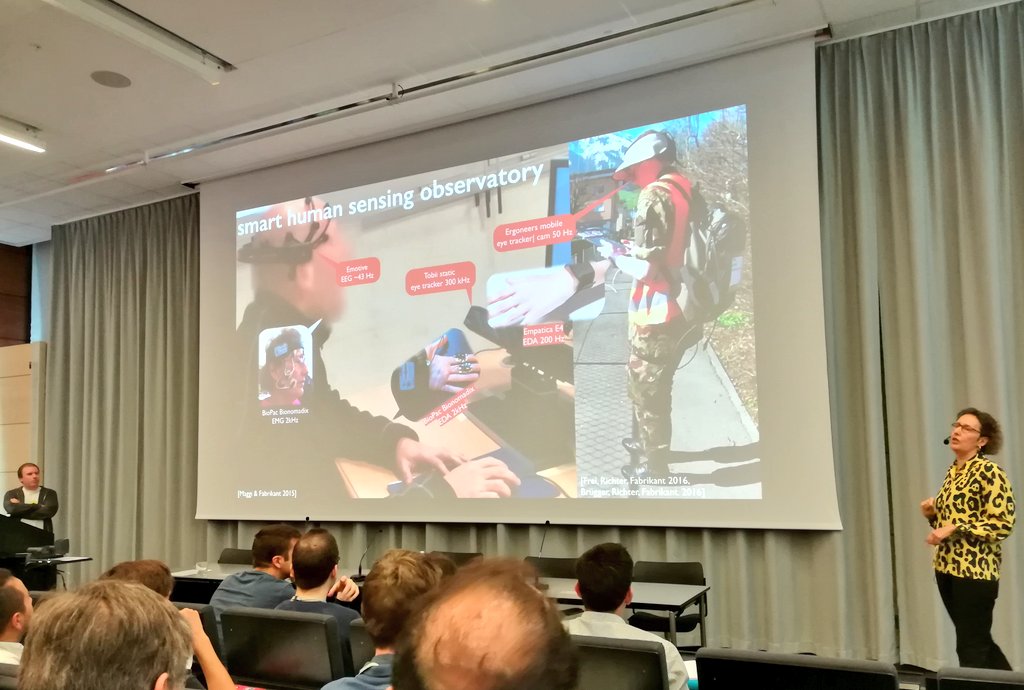
Sara Fabrikant held her keynote "Smart mobile citizen sensing for wise decisions of
tomorrow’s digital society". In her talk, Sara highlighted ongoing empirical research on human and context responsive geographic information displays used in the GIVA labs and in the wild, capitalizing on ambulatory human behavior sensing methods (i.e., eye tracking, galvanic skin response, and EEG measurements, etc.). Her talk stimulated interessting discussions on designing smart, user, task, and context responsive geographic information interfaces for tomorrow’s digital society.The special session Mobilities and Health was co-organized by the GIUZ. In his presentation with the title "Identifying activity spaces from geo-referenced Twitter data: Superstorm Sandy, mobility patterns, and emotions in New York City" Ivor Mardesic showcased how georeferenced social media data can be used to identify activity spaces and emotions.
GIVA says thank you to the organizers and all staff members for the welcoming atmosphere and the professional organization.
-
Winner of the Best Article of the Year
The Psychonomic Society honors individuals for the best paper published in each Psychonomic Society journal in the last year. The nomination of the paper is based on a vote of the associate editors. The winner of the Best Paper of the Year for the journal Cognitive Research: Principles and Implications in 2019 is awarded to Annina Brügger, Kai-Florian Richter and Sara I. Fabrikant for their paper " How does navigation system behavior influence human behavior?". The journal publishes new empirical and theoretical work covering all areas of Cognition, with a special emphasis on use-inspired basic research. GIVA congratulates Aninna, Kai-Florian, and Sara to this terrific success!
-
International Cartographic Conference 2019
Strong showing of GIVA at the International Cartographic Conference held from July 15 - 20, 2019 in Tokyo, Japan.
In the Waldo Tobler memorial session, Sara Fabrikant, Aileen Buckley, Menno-Jan Kraak,Timothy Trainor, and Harold Moellering put the scientific work of Waldo Tobler in the spotlight. The session led to great discussions and new inspiring research questions for the community.
In the conference presentation track, Sara Fabrikant presented the results of Michelle Korporaal's Master thesis. In her work How are map-based decisions influenced by uncertainty visualization in risky and time-critical situations?, she could show that decision-making processes were different when slope uncertainty was depicted.
A way how cartographers might better understand how people make decisions with maps is to create new research tools for the community. Tumasch Reichenbacher presented A tool for generating testable pop-out effects in geovisual displays. We are looking forward to see the first prototype.
Tumasch Reichenbacher also presented at the Mobile Map UX workshop. In his lightning talk Re-visiting Fundamental Principles of Mobile Cartography, Tumasch Reichenbacher outlined the major research challenges regarding user experience design for mobile cartography.
-
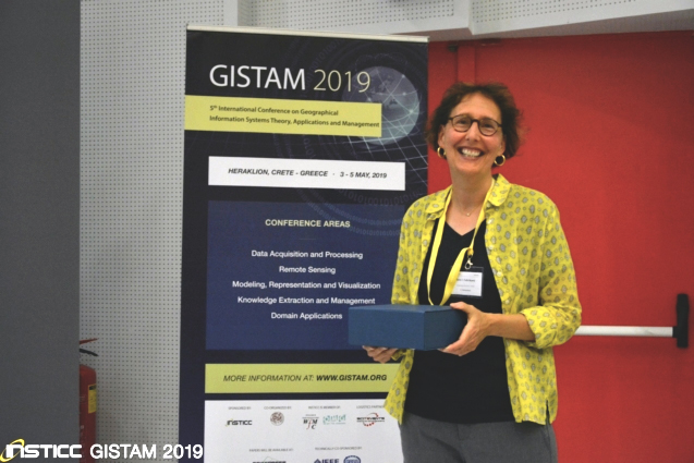
Keynote @ GISTAM 2019
Sara Fabrikant held her keynote at the 5th GISTAM conference in Heraklion, Crete – Greece on 3-5 May, 2019. In her talk "Smart Geographic Information Displays for Wise Decision Making" Sara highlighted how cognition and vision theories support the process of designing human, task, and context responsive geographic information interfaces for wise decisions of the future digital society.
-
Dagstuhl Seminar on Visual Analytics for Sets over Time and Space
Together with Silvia Miksch (TU Wien, AT) and Alexander Wolff (Universität Würzburg, DE), Sara Fabrikant organized and attended the Dagstuhl-Seminar on Visual Analytics for Sets over Time and Space. The seminar was held 5 - 10 may 2019 and brought together researchers from different fields to work on enhancing space-time visualizations. The main goal of that workshop was to identify specific theoretical and practical problems that need to be solved in order to create dynamic and interactive set visualizations that take into account time and space. Results will be published soon in the monthly Dagstuhl Reports https://www.dagstuhl.de/en/publications/dagstuhl-reports/ .
-
Updated MSc topics
Dear MSc students,
There are many ways to find a MSc research topic. A very helpful starting point is to have a look at our updated webpage of MSc topics. With our new arrivals Oliver and Tumasch at GIVA, we can also offer some exciting novel topics. Of course you can also always approach us with your own ideas. Feel free to contact one or more of the relevant supervisors already some time before the start of the thesis to discuss a possible startup/subject. Thanks and see you!
-
New publications
New publications by GIVA members:
-
GIVA welcomes new staff
GIVA is glad to welcome Armand, Oliver, and Tumasch, the three new members of the team! Tumasch Reichenbacher is a senior scientist and a specialist in analyzing and visualizing geographic information. Tumasch gives the lecture in cartography (GEO123) this spring. Oliver Grübner is a senior researcher in Epidemiology and Biostatistics. In his research, he uses spatial epidemiological approaches to chronic diseases including mental health and he tries to understand how social media can be leveraged in this context. At GIVA, Oliver teaches the Geovisualization (GEO878) and Statistics (GEO246) courses this spring. Armand Kapaj is the new PhD student in the context of the ERC Advanced Project GeoViSense.
We’re thrilled to have you on board !
-
EMOtive research featured in a televised report
Humans inscreasingly navigate using smart mapping apps. While this geographic information technology is convenient, it is limited in supporting us in our cognitive abilities to orient ourselves in space, and to acquire knowledge about our surroundings. In the SNF supported Emotive project, Sara Irina Fabrikant, Kai-Florian Richter, Annina Brügger and Sascha Credé investigate how smart navigation assistants of the future should be designed to not only take navigators and wayfinders safely to their desired destinations, but also to support them in learning to orient and wayfind themselves. This Emotive research has been featured in a televised report, developed by the SRF Nano team. You can see the broadcasted video here. We wish take the opportunity to thank the SRF Nano team for this expressive results of a pleasant and professional collaboration.
-
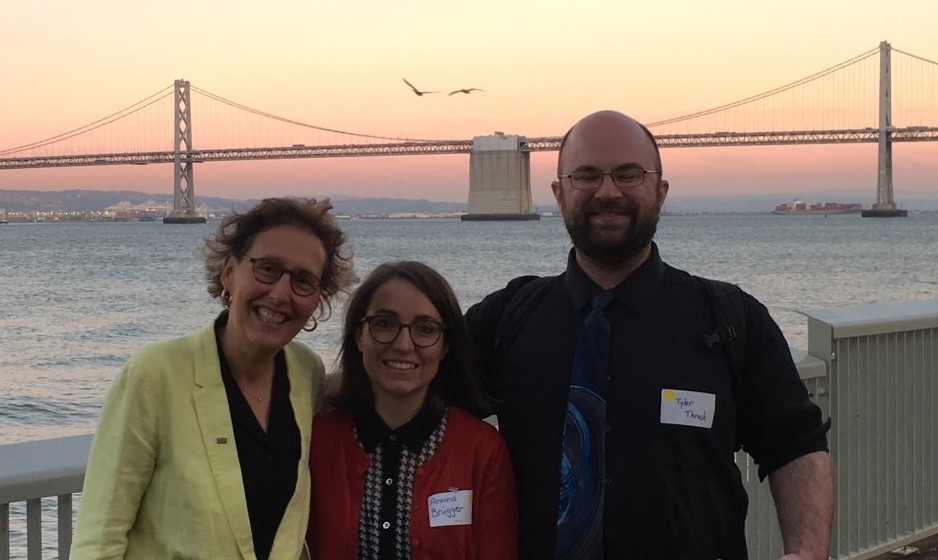
Zürich meets San Francisco
Sara Irina Fabrikant, Tyler Thrash and Annina Brügger organized a workshop on Wayfinding and Navigation as part of the Urban Tech Summit at the event "Zürich meets San Francisco" in corporation with swissnex SF on Oct, 23, 2018 in San Francisco (US). In Santa Barbara, they hosted a workshop on geographic information displays (GIDs) at the Center for Spatial Studies at UCSB and visited the companies Biopac and WorldViz to get informed on the latest developments on physiology experiments and virtual reality.
-
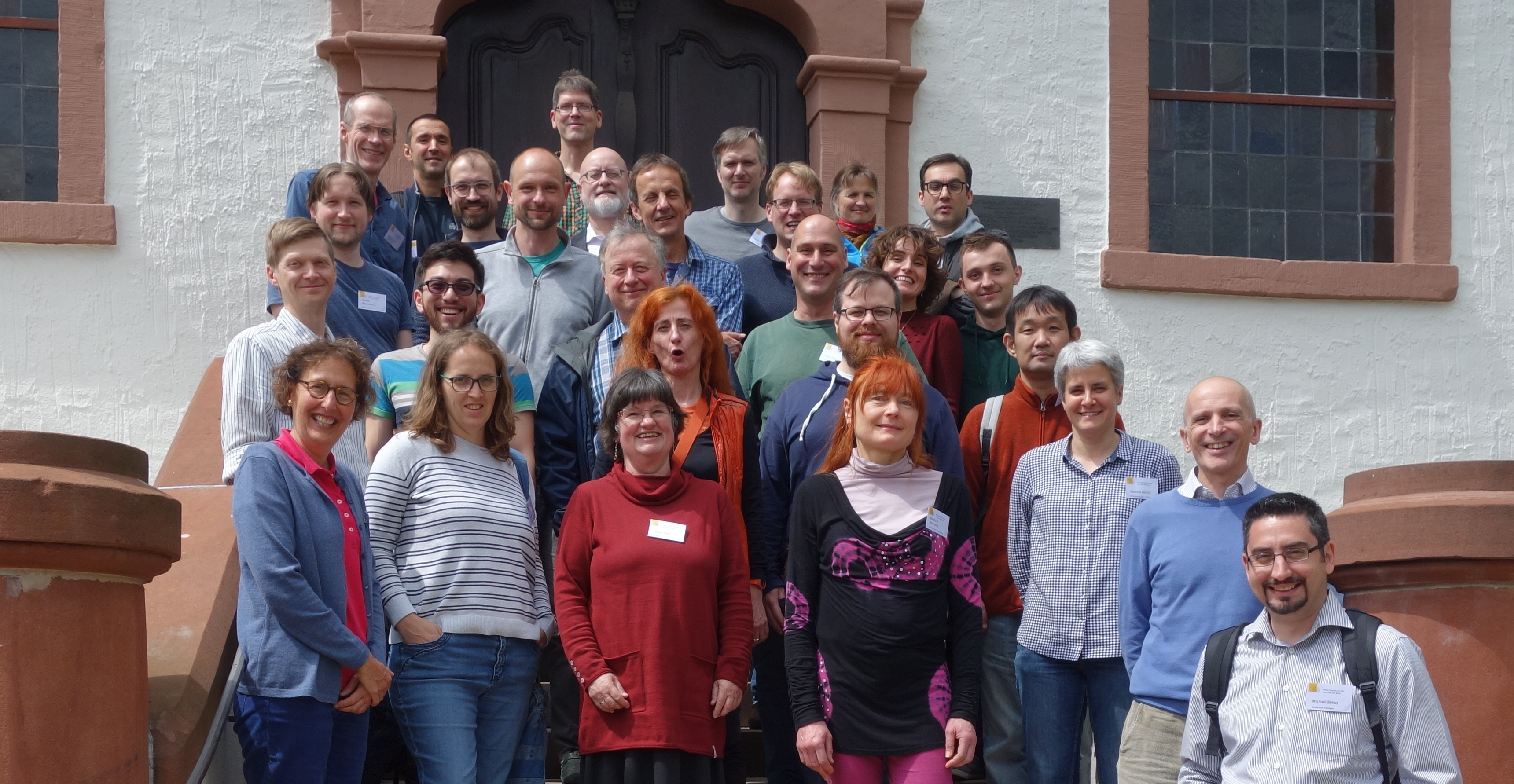
GeoViSense Workshop
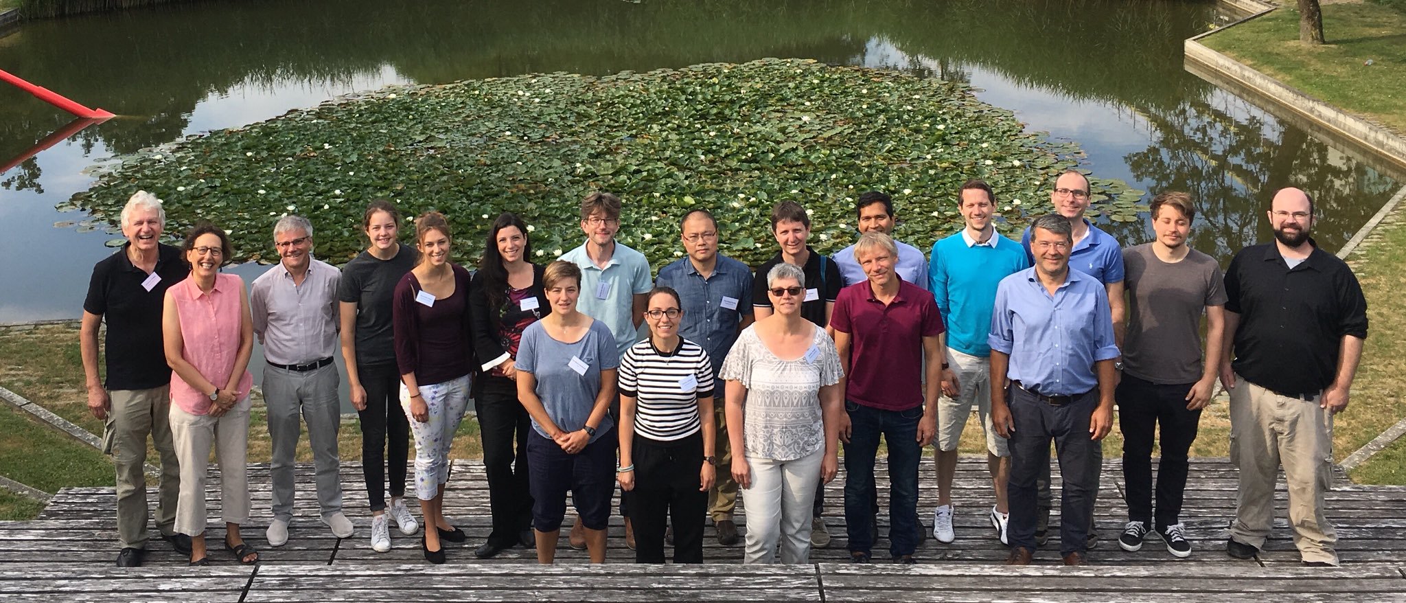
As part of the new ERC Advanced Grant "GeoViSense", Sara Fabrikant and team organized a two-day workshop in Zurich on the topic of personalized and context-responsive geographic information displays (GIDs). We invited participants from around Europe in order to discuss the future of GIDs and devise designs for GIDs during a series of small group exercises. The participants included experts from various disciplines, including computer science, cognitive science, geography, and neuroscience. GIVA says thank you for your most valuable input!
-
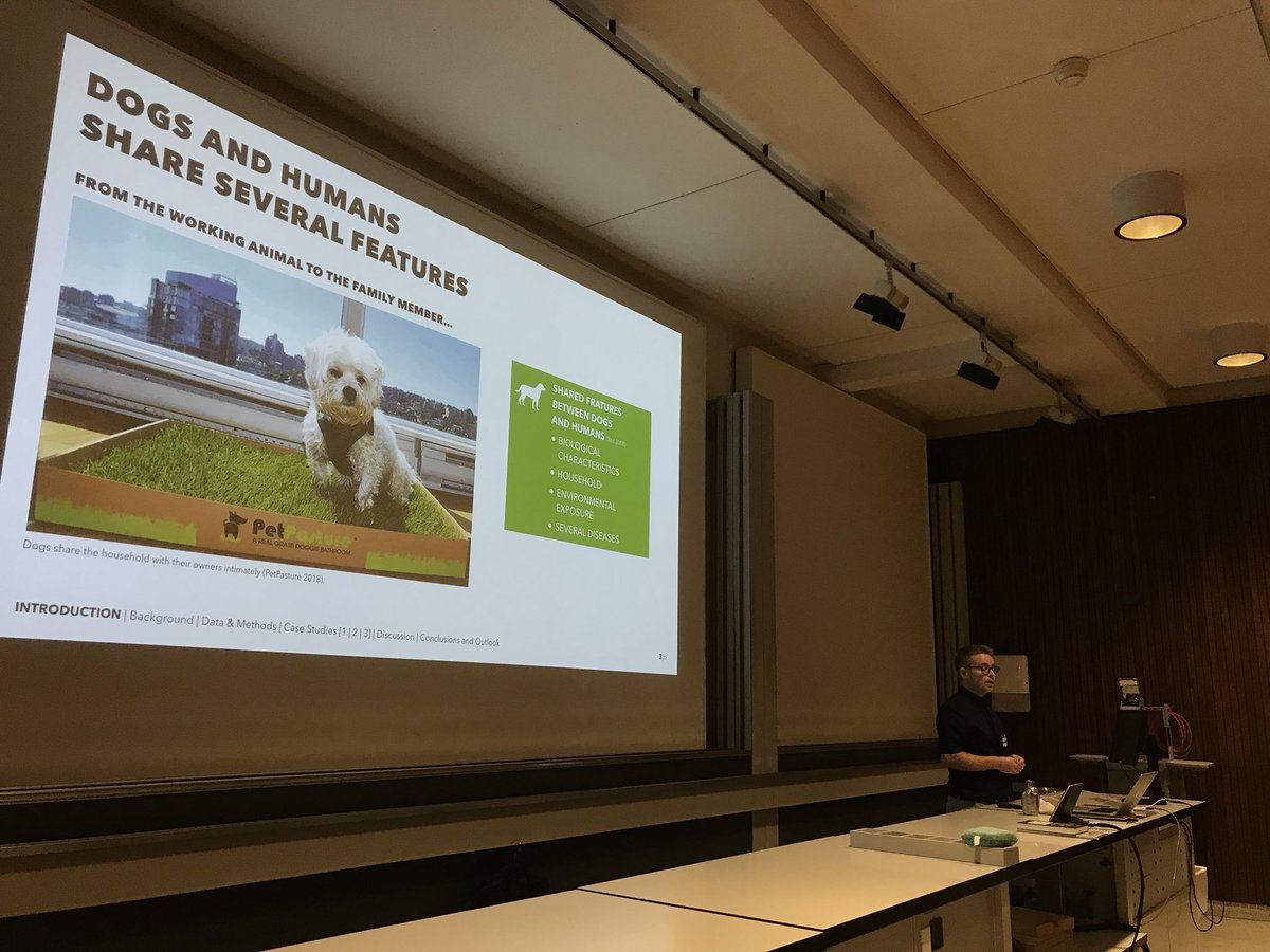
Congratulations to Gianluca Boo!
With great pleasure we announce that Gianluca Boo has successfully defended his PhD thesis on “Dogs as Sentinels for Environmental Cancers Addressing the Challenges of Spatial Epidemiology”. Congratulations from the GIVA group. We wish Gianluca all the best for his future plans!
-
Keynote @ AGILE2018
Sara Fabrikant held her keynote at the 21st AGILE conference in Lund, Sweden on 12-15 June, 2018. In her talk "Geotechnologies for All: Leaving All for Last" Sara highlighted ongoing empirical research on human and context responsive geographic information displays. Her talk stimulated interessting discussions on designing human, task, and context responsive geographic information interfaces for all.
-
Day of Computer Science 2018
Relying on digital navigation assistance is often the most comfortable way of finding one's way through unfamiliar places. However, we typically don't pay a lot of attention to the path we are following and when assistance is not available anymore, we find ourselves disoriented. What are the reasons for this negative relation and how can we improve navigation displays so that they support orientation in the long term? At the Tag der Informatik, GIVA demonstrated their virtual reality laboratories to a public audience. Sascha Credé, Marie Müller and Arzu Cöltekin illustrated how empirical user studies in virtual cities can help to answer these questions. We like to say thank you for your interest and for the good discussions!
-
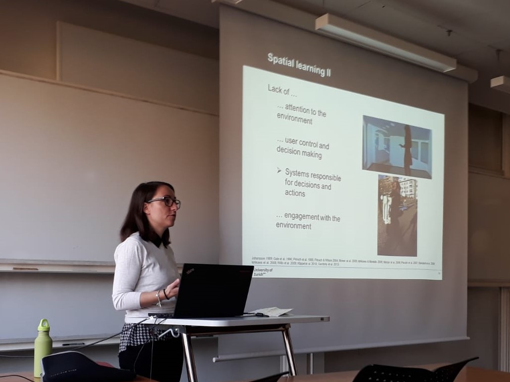
GIVA @ Spatial Cognition Conference
Strong showing of GIVA members at the Spatial Cognition 2018 in Tübingen, Germany. All submissions (three posters and two workshops) were accepted and will be presented in Tübingen, Germany, September 5-8, 2018. We are looking forward to have interesting discussions.
-
Research stay and seminar talk at Umeå University, Umeå, Sweden
During her research stay at the Computing Science Department at Umeå University, Annina Brügger extended her knowledge of Computing Science, human-computer interaction (HCI) and artificial intelligence (AI). Her talk titled "Automation in navigation systems - a focus on spatial learning" gave the audience an insight into automated systems and cognition from a spatial, geographical perspective. The talk and the research stay stimulated interesting and interdisciplinary discussions.
-
Greater Zurich Area – a Center of Competence for Geographic Information Display
When seeking directions towards a new restaurant or the quickest connection to the office, people will retrieve their smartphones and navigate towards the destination almost effortlessly. However, does the ease with which we can now find our way come with a price? Will the use of such technologies lead to a decrement in the spatial abilities of the users? Read more in Tyler Trash's contribution for the "Greater Zurich Area Blog".
-
Presentation @ ICA Joint Workshop on Atlases, Cognition, and Usability 2018
Arzu Coltekin had a talk at the ICA Commissions Joint Workshop on Atlases, Cognition, and Usability, 2018 in Olomouc (Czechia). In the joint workshop, researchers discussed fundamental cognitive and usability issues related to carographic visualizations. In her talk, Arzu presented recent work on how age and spatial abilities influence route learning performance in virtual environments. For more details about the workshop, find the program here
-
Presentation @ AAG 2018 Annual Meeting
How do we map what is not there? The understanding of efficient uncertainty visualization is a challange in cartographic design. Sara I. Fabrikant presented recent empirical findings on uncertainty visualizations at the American Association of Geographers' 2018 Annual Meeting. The symposium focused on research related to climate change visualization and mapping. For details about the symposium and the presented work, which is related to Irene Johannsen's Master thesis, please check out here
-
Presentations @ ET4S Workshop
Annina Brügger, Ismini Lokka, Kenan Bektas and Arzu Cöltekin attended the 3rd International Workshop on Eye Tracking for Spatial Research (ET4S 2018) in Zurich (Switzerland) on January 14, 2018. They presented their work on eye tracking in oral talks and demo sessions. The ET4S workshop brought together researchers from different areas who have a common interest in using eye tracking for research questions related to spatial information.
Check out the Workshop Proceedings
-
Sara Maggi @ Graduation Ceremony
Dekan Roland Sigel, GIVA's newest graduate Sara Maggi and Sara Irina Fabrikant at graduation ceremony. GIVA wishes Sara Maggi all the best and every success for the future.
-
Congratulation for defending his PhD thesis!
We congratulate Kenan Bektas who defended his PhD thesis "Gaze Contingent Geovisualization for Level of Detail Management" successfully on december 1st, 2017. GIVA would like to thank him for his strong commitment and wish him every success in his future career. The picture shows Kenan Bektas & Sara Maggi together with their supervisors at the internal graduation ceremony on the university campus (from left to right: Sara Irina Fabrikant, Sara Maggi, Kenan Bektas, Arzu Coltekin.)
-

Open PhD Position – ERC Advanced Project GeoViSense
Are you interested in carrying out a PhD? We are happy to invite applications for a doctoral research position in the context of the ERC Advanced Project GeoViSense, led by the GIVA group head and PI Sara Irina Fabrikant. This project, at the interface of GIScience (geovisual analytics) and neuro-cognitive science aims to study how we make space-time decisions with geographic information displays (GIDs) in varying mobile decision making contexts.
For more details please see the official advertisement
-
Open PhD Positions – ERC Advanced Project GeoViSense
Are you interested in carrying out a PhD? We are happy to invite applications for a doctoral research position in the context of the ERC Advanced Project GeoViSense, led by the GIVA group head and PI Sara Irina Fabrikant. This project, at the interface of GIScience (geovisual analytics) and neuro-cognitive science aims to study how we make space-time decisions with geographic information displays (GIDs) in varying mobile decision making contexts.
For more details please see the official advertisement
-
Winners of the Michael Breheny Prize
The Michael Breheny Prize is awarded annually for the most innovative paper in Environment and Planning B: Urban Analytics and City Science. The paper is chosen by the editors assisted occasionally by members of he editorial board of the journal. This year all four editors, Michael Batt, Richard Harris, Linda See and Sarah Williams with Dr. Seraphim Alvenides of Northumbria University made the choice, agreeing that the best paper published in 2016 be awarded to Marco. M. Salvini and Sara I. Fabrikant for their paper "Spatialization of user-generated content to uncover the multirelational world city network".
Congrats for this international recognition of former GIVA member Dr. Marco Salvini. Marco already received an UZH Science Distinction in 2012 for his PhD research.
-

GIVA @ ET4S
Strong showing of GIVA members at the 3rd International Workshop on Eye Tracking for Spatial Research as part of the LBS 2018 conference: two short-papers and one Demo case were accepted for oral presentation in Zürich, January 14-17, 2018.
See the program here
-
Giva @ COSIT 2017
Sascha Credé, Annina Brügger, Sara Irina Fabrikant and Kai-Florian Richter (former GIVA member) attended the 13th International Conference on Spatial Information Theory (COSIT) in l'Aquila (Italy) from 4th to 8th of September 2017. Besides presenting at the doctoral colloquium (Annina Brügger) and at the workshop Rethinking Wayfinding Support Systems (Sascha Credé), they both won a Best Poster Award (first and third place). Congratulations!
-
Join cutting edge research @ GIVA
GIVA invites motivated researchers for applications for two doctoral and two post-doctoral research positions in the context of the ERC Advanced Project GeoViSense, lead by the GIVA group head and PI Sara Irina Fabrikant.
-
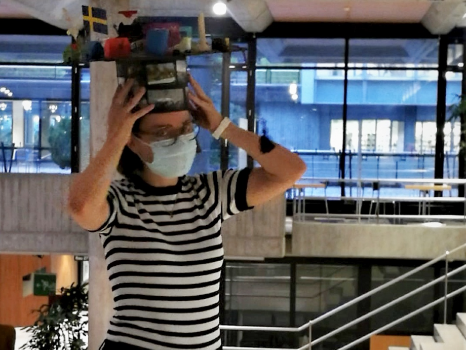
Master Thesis Questionnaire on the Visualization of Data Quality
Irene Johannsen, a geography student of Bonn University, Germany,
is writing her master thesis with GIVA. She is interested in the visualisation
of data quality in climate change maps. For that purpose she developed
an online questionnaire which addresses geographers and laypersons.
Feel free to participate (20 minutes). You’d make a Master’s student’s day! -
EuroVis 2017 Conference
Halldór Janetzko and colleagues presented their recent work on soccer movement generalization at the 19th EG/VGTC Conference on Visualization in Barcelona from 12th to 16th June. They won the Honorable Mention Award for their full paper on „Dynamic Visual Abstraction of Soccer Movement“.
-
GIVA @ Urban Wayfinding and the Brain Conference 2017
Ismini E. Lokka and Annina Brügger presented their posters at the Urban Wayfinding and the Brain conference organized by the Royal Institute of Navigation, University College London and The Knowledge Transfer Network in London on June 14, 2017.
-
Visiting students from FHNW
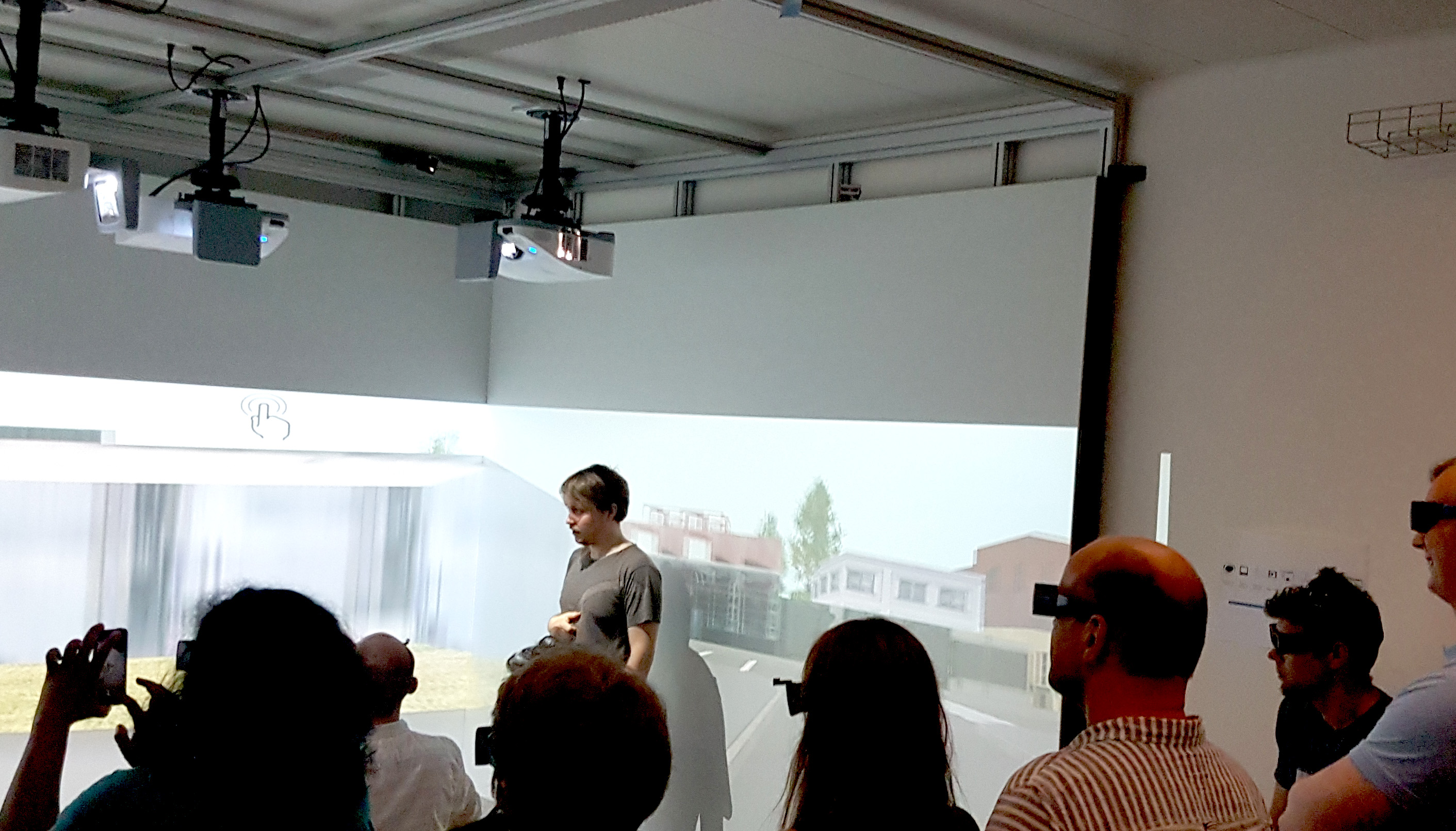
Along with the other units in GIScience Center, we hosted an excursion for 19 Geomatics students from the Institute of Geomatics Engineering FHNW on 16th of May 2017. After an overview of the research activities in respective groups, we demonstrated our CAVE where students explored the lab as a visualization research environment.
-
Congratulations!
With great pleasure we announce that Sara Maggi has successfully defended her PhD thesis on “Depicting Movement Data with Animations for Embodied and Real-Time Decision-Making: A User Study with Air Traffic Control Displays and Real-Time Movement Data”. Congratulations from the GIVA group!
-
VISDOM project update
GIVA received an SNF grant for an additional year for the VISDOM project, with Arzu Coltekin as the principle investigator (PI), Sara Fabrikant and Kai-Florian Richter as co-PIs, and Ismini-Eleni Lokka as the PhD candidate. You can find additional information on the project and a publication list on the following page: link
-
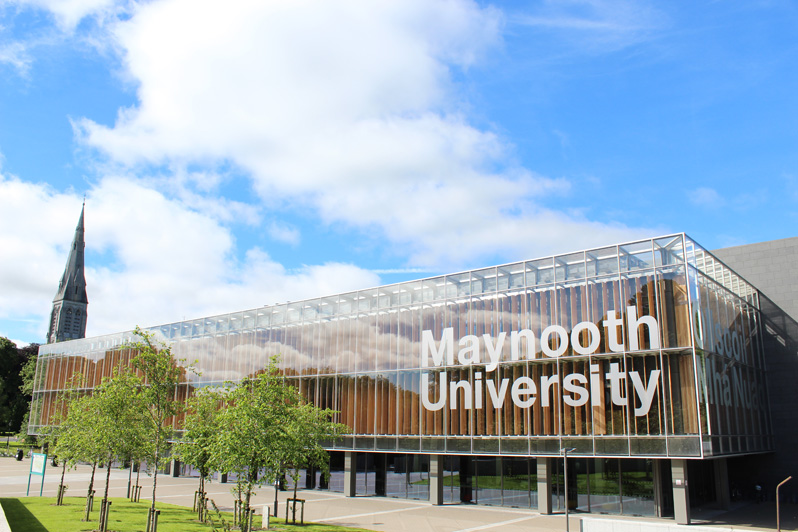
Academic visit at the University of Maynooth, Ireland
Gianluca Boo was invited for an academic visit at the National Centre for Geocomputation (NCG) University of Maynooth, Ireland. Together with Prof. Chris Brunsdon, the director of the centre, Gianluca worked on a manuscript titled “A robust investigation of spatial-non stationarity and scale effects in models of canine cancer incidence”.
-
-
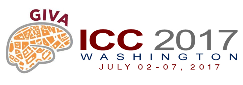
GIVA @ International Cartographic Conference 2017
Strong showing of GIVA members at the 28th International Cartographic Conference 2017: All 6 submissions (extended abstracts) were accepted for oral presentation at the main conference in Washington, July 2-7, 2017.
-
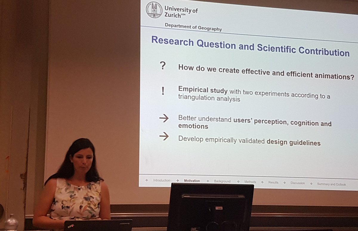
ThinkSpatial brownbag talk at the University of California, Santa Barbara (UCSB)
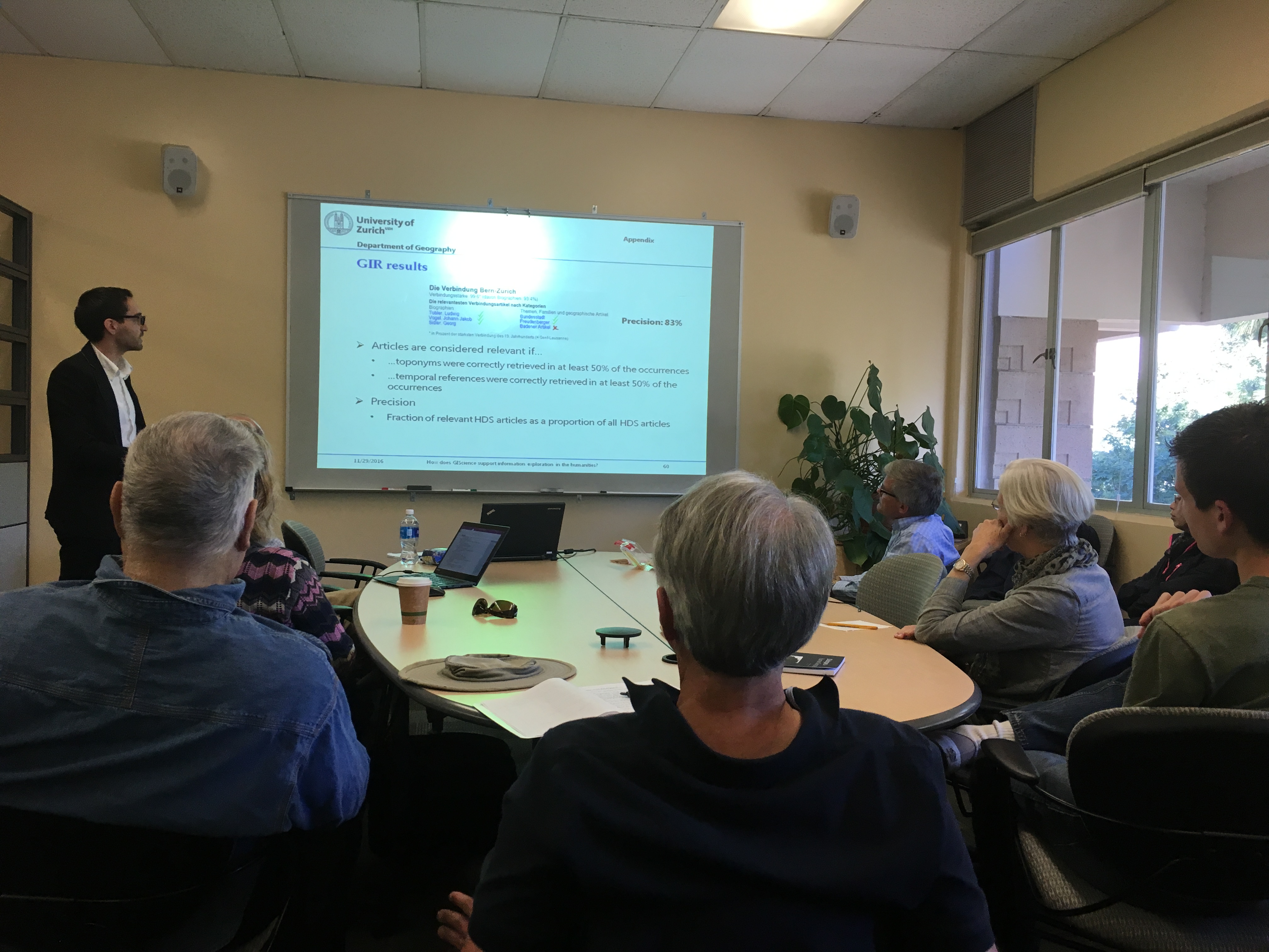
André Bruggmann was invited to give a ThinkSpatial brownbag talk at the Center for Spatial Studies of the University of California, Santa Barbara (UCSB). In his talk titled „How Does GIScience Support Spatio-Temporal and Thematic Information Exploration in the Humanities“ he presented latest findings of his PhD project on how spatio-temporal and thematic information and interconnections implicitly stored in large online text archives in the humanities can be made explicit, and how this might help information seekers in the humanities learn and gain new insight into space, time, and theme. Find a detailed description of his talk here.
-
GIScience Conference 2016
Sara Irina Fabrikant, Gianluca Boo and Annina Brügger each presented their current work at the GIScience 2016 conference in Montreal, Canada, from September 27 to 30. Gianluca Boo won the award for the best poster presentation and Annina Brügger won the award for the best short paper.