Geographic Information Visualization and Analysis (GIVA)
Grid containing content elements

Additional Information
News

Upcoming events
-
18.5.2026, 09:30: MSc Exam l A Leisure Attractivity Framework for Destination Choice in Travel Demand Models
Stefano Benzoni; Ort: Y35, Winterthurerstrasse 190, 8057 Zürich; Raum: F-47
-
18.5.2026, 13:30: MSc Exam l Evaluation der Usability eines Geografischen Informationssystems für Landwirtinnen und Landwirte
Sina Spirig; Ort: Y35, Winterthurerstrasse 190, 8057 Zürich; Raum: F-47
-
18.5.2026, 14:05: MSc Exam l Seeing Street Color, Sensing Street Mood
Nian Li; Ort: Y35, Winterthurerstrasse 190, 8057 Zürich; Raum: F-47
-
18.5.2026, 14:40: MSc Exam l Operational Sectorization for Earthquake Response: A Mixed-Methods Quality Analysis and Revised Generation Approach for Switzerland and Liechtenstein
Michael Fehr; Ort: Y35, Winterthurerstrasse 190, 8057 Zürich; Raum: F-47
-
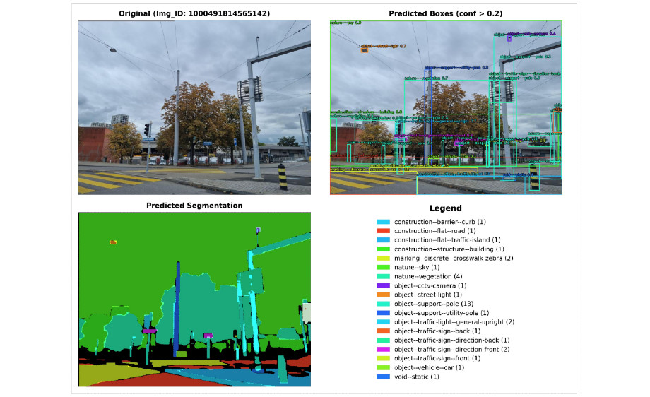
19.5.2026, 13:30: MSc Exam l Detecting Pedestrian Accessibility Features Using Deep Learning: A Case Study in the City of Zurich with Street View Imagery
Leqi Wang; Ort: Y35, Winterthurerstrasse 190, 8057 Zürich; Raum: F-47