New Publication

The effect of landmark visualization in mobile maps on brain activity during navigation: A virtual reality study
Front. Virtual Real., 15 November 2022
Cheng, B., Wunderlich, A., Gramann, K., Lin, E., & Fabrikant, S. I
Abstract
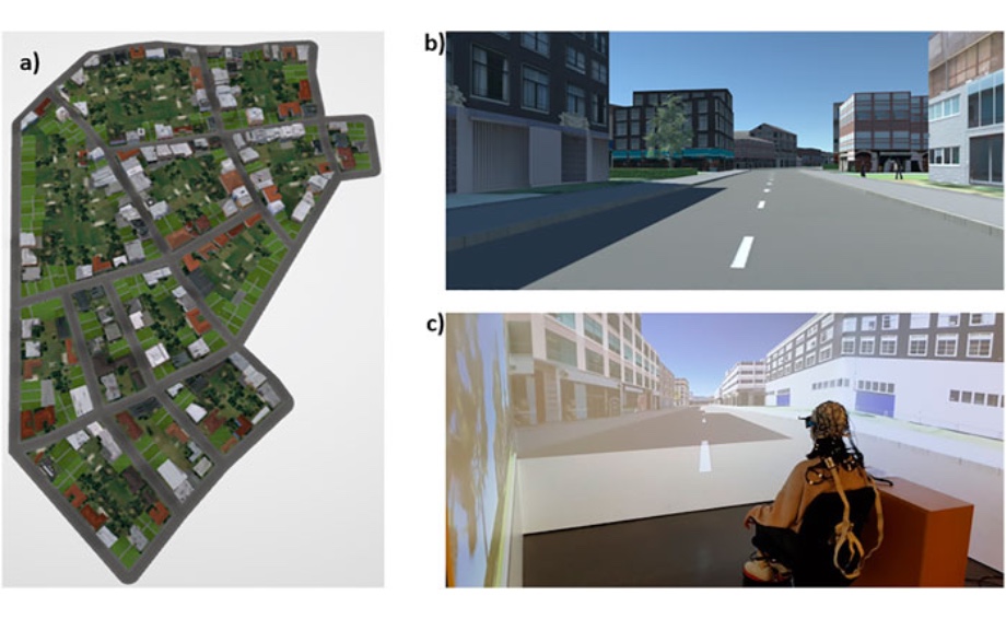
The frequent use of GPS-based navigation assistance is found to negatively affect spatial learning. Displaying landmarks effectively while providing wayfinding instructions on such services could facilitate spatial learning because landmarks help navigators to structure and learn an environment by serving as cognitive anchors. However, simply adding landmarks on mobile maps may tax additional cognitive resources and thus adversely affect cognitive load in mobile map users during navigation. To address this potential issue, we set up the present study experimentally to investigate how the number of landmarks (i.e., 3 vs. 5 vs. 7 landmarks), displayed on a mobile map one at a time at intersections during turn-by-turn instructions, affects spatial learning, cognitive load, and visuospatial encoding during map consultation in a virtual urban environment. Spatial learning of the environment was measured using a landmark recognition test, a route direction test, and Judgements of Relative Directions (JRDs). Cognitive load and visuospatial encoding were assessed using electroencephalography (EEG) by analyzing power modulations in distinct frequency bands as well as peak amplitudes of event-related brain potentials (ERPs). Behavioral results demonstrate that landmark and route learning improve when the number of landmarks shown on a mobile map increases from three to five, but that there is no further benefit in spatial learning when depicting seven landmarks. EEG analyses show that relative theta power at fronto-central leads and P3 amplitudes at parieto-occipital leads increase in the seven-landmark condition compared to the three- and five-landmark conditions, likely indicating an increase in cognitive load in the seven-landmark condition. Visuospatial encoding indicated by greater theta ERS and alpha ERD at occipital leads with a greater number of landmarks on mobile maps. We conclude that the number of landmarks visualized when following a route can support spatial learning during map-assisted navigation but with a potential boundary—visualizing landmarks on maps benefits users’ spatial learning only when the number of visualized landmarks shown does not exceed users’ cognitive capacity. These results shed more light on neuronal correlates underlying cognitive load and visuospatial encoding during spatial learning in map-assisted navigation. Our findings also contribute to the design of neuro-adaptive landmark visualization for mobile navigation aids that aim to adapt to users’ cognitive load to optimize their spatial learning in real time.
More news
- New Publication
- The GIVA class of 2023
- New Publication
- UZH Postdoc Team Award
- New Publication
- New Publication
- Mini Symposium at the IEM
- New Publication
- COSIT 2022: Best Short Paper Award
- COSIT 2022
- New Publication
- New Publication
- New Publication
- New Publication
- New Publication
- New Publication
- New Publication
- New Publication
- New Publication
- New Publication
- ICC Conference 2021
- CRAN - Package fca
- Capturing mood and affective states via Twitter
- Innovathon, Sep 30 - Oct 2, 2021
- GIScience Conference 2021
- New Publication
- ICC 2021
- Scientifica, September 4-5, 2021
- New Publication
- New Publication
- New Publication
- New Publication
- New Publication
- New Publication
- New Publication
- SRF: Swisstopo
- New Publication
- New Publication
- New Publication
- Ist das Navi in der Hand der erste Schritt zum betreuten Wohnen?
- "The Eyes Have It!" - Where we look while navigating
- «I see and I remember. I do and I understand.»
- Numbed by navigation technologies: How can we counteract?
- Use of Location-Based Information for Smart Governance
- How do we get there? Adaptive and effective design of mobile navigation assistance devices
- Defense Lokka Ismini
- Defense Brügger Annina
- Researching a pandemic - during a pandemic
- New Publication
- GIScience Resilience Panel
- Resilient Pedagogy for GIScience Education
- New Publication
- Open PhD position - Visual analytics of mobile behaviour data in digital cities
- Congratulations to Sascha Credé!
- New publications
- GIVA welcomes new staff
- COSIT 2019 in Regensburg
- GIVA @ ECTQG2019
- Winner of the Best Article of the Year
- International Cartographic Conference 2019
- Keynote @ GISTAM 2019
- Dagstuhl Seminar on Visual Analytics for Sets over Time and Space
- Updated MSc topics
- New publications
- GIVA welcomes new staff
- EMOtive research featured in a televised report
- Zürich meets San Francisco
- GeoViSense Workshop
- Congratulations to Gianluca Boo!
- Keynote @ AGILE2018
- Day of Computer Science 2018
- GIVA @ Spatial Cognition Conference
- Research stay and seminar talk at Umeå University, Umeå, Sweden
- Greater Zurich Area – a Center of Competence for Geographic Information Display
- Presentation @ ICA Joint Workshop on Atlases, Cognition, and Usability 2018
- Presentation @ AAG 2018 Annual Meeting
- Presentations @ ET4S Workshop
- Sara Maggi @ Graduation Ceremony
- Congratulation for defending his PhD thesis!
- Open PhD Position – ERC Advanced Project GeoViSense
- Open PhD Positions – ERC Advanced Project GeoViSense
- Winners of the Michael Breheny Prize
- GIVA @ ET4S
- Giva @ COSIT 2017
- Join cutting edge research @ GIVA
- Master Thesis Questionnaire on the Visualization of Data Quality
- EuroVis 2017 Conference
- GIVA @ Urban Wayfinding and the Brain Conference 2017
- Visiting students from FHNW
- Congratulations!
- VISDOM project update
- Academic visit at the University of Maynooth, Ireland
- Designing-memorable-3D-geovisualizations-for-the-elderly
- GIVA @ International Cartographic Conference 2017
- ThinkSpatial brownbag talk at the University of California, Santa Barbara (UCSB)
- GIScience Conference 2016