Navigation auf uzh.ch
Navigation auf uzh.ch
Global biodiversity assessments require the collection of data on changes in plant biodiversity on an ongoing basis. Researchers from GIUZ and the University of Montréal have now shown that plant communities can be reliably monitored using imaging spectroscopy, which in the future will be possible via satellite. This paves the way for near real-time global biodiversity monitoring.
Internationally comparable data on biodiversity is needed to protect threatened ecosystems, restore destroyed habitats and counteract the negative effects of global biodiversity loss. Current biodiversity monitoring, however, is labor-intensive and costly. In addition, many places around the world are difficult to access.
Anna Schweiger from the Remote Sensing Laboratories at the Department of Geography, University of Zurich (UZH), and Etienne Laliberté from the University of Montréal, have now shown that plant biodiversity across ecosystems ranging from Arctic tundra to tropical forests can be reliably assessed using image spectrometry. “With our study, we hope to contribute to the future detection of changes in species composition of our Earth’s ecosystems from space. The goal is to provide evidence-based guidance for policy measures to protect species and mitigate negative consequences of biodiversity loss,” says first author Anna Schweiger.
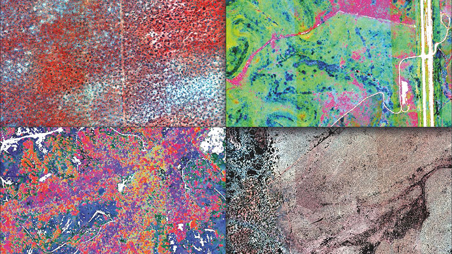
Imaging spectrometers measure the reflectance of light from the visible to the shortwave infrared range of the electromagnetic spectrum. The reflectance of plants is determined by their chemical, anatomical and morphological characteristics, which are important for interactions among plants and with their environment. “Plants with similar traits, as well as closely related species, therefore tend to have similar reflectance spectra,” explains Schweiger.
The current study is a continuation of the researchers’ work on spectral diversity metrics. Their indices calculate spectral variation among individual plants within communities, and among communities within a region. The diversity within communities is called alpha-diversity, while the diversity among communities is called beta-diversity.
Data for the study came from the National Ecological Observatory Network (NEON). The network uses standardized methods to collect biodiversity and Earth observation data across the United States which are then made publicly available. NEON imaging spectrometer data collected from research flights have a pixel size of 1x1 meter.
Spectral diversity calculations showed that the detection of alpha-diversity depends on plant size. Spectral diversity calculated in forests with closed canopies and large individual trees matched plant diversity determined on the ground better than spectral diversity calculated in open landscapes dominated by small herbaceous plants and grasses. Spectral beta-diversity, however, captured differences in plant community composition across all ecosystems studied based on a spatial resolution of 20x20 meters. This pixel size corresponds to the size of NEON’s vegetation inventory plots.
Both the European Space Agency (ESA) and its North American counterpart NASA are currently developing satellite-based image spectrometers. These are intended to image the entire globe approximately every 16 days with a pixel size of about 30x30 meters. The study’s results illustrate that these data should allow detecting ecosystem changes as they happen. “Our study will help to effectively and reliably determine changes in plant community composition via satellite in the foreseeable future. This will facilitate targeted field campaigns to assess the causes and consequences of ecosystem change allowing stakeholders to react in due time,” says Anna Schweiger. According to Schweiger, global monitoring of biodiversity – almost in real time – is now within reach.
Anna K. Schweiger, Etienne Laliberté. Plant beta-diversity across biomes captured by imaging spectroscopy. Nature Communications. 19 Mai 2022. DOI: 10.1038/s41467-022-30369-6
News Release, University of Zurich