#50: Why do we create virtual forests?
Combining 3d measurements and radiative transfer models helps to improve forest monitoring and to increase understanding of ecosystem functioning.
Given the increased pressure on forests and their diversity in the context of global change, new ways of monitoring diversity are needed. A set of globally relevant and consistent variables has been defined and been named essential biodiversity variables (EBVs), analogous to the essential climate variables (ECVs). Remote sensing has the potential to inform these variables on the global scale, but validation of data and products, particularly in remote areas, is difficult. We have developed an approach using radiative transfer models, parameterised with a detailed 3d forest reconstruction based on laser scanning, that can be used to test and validate information retrieval from remote sensing, purely in the virtual domain.
3d remote sensing technologies providing forest structure information
For the 3d reconstruction of the vegetation canopy needed in our models, we use laser scanning across a range of scales. This technology enables us to reconstruct trees with branches if we use close-range laser scanning (either from the ground or from drones) and the location of trees in the landscape if we use laser scanning from airborne platforms. In addition, it provides a direct source of so-called morphological traits, which are as well relevant in the context of EBV retrieval, as shown in a very recent paper, to which we contributed .
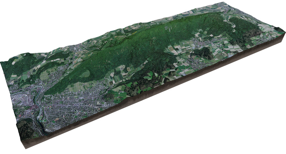
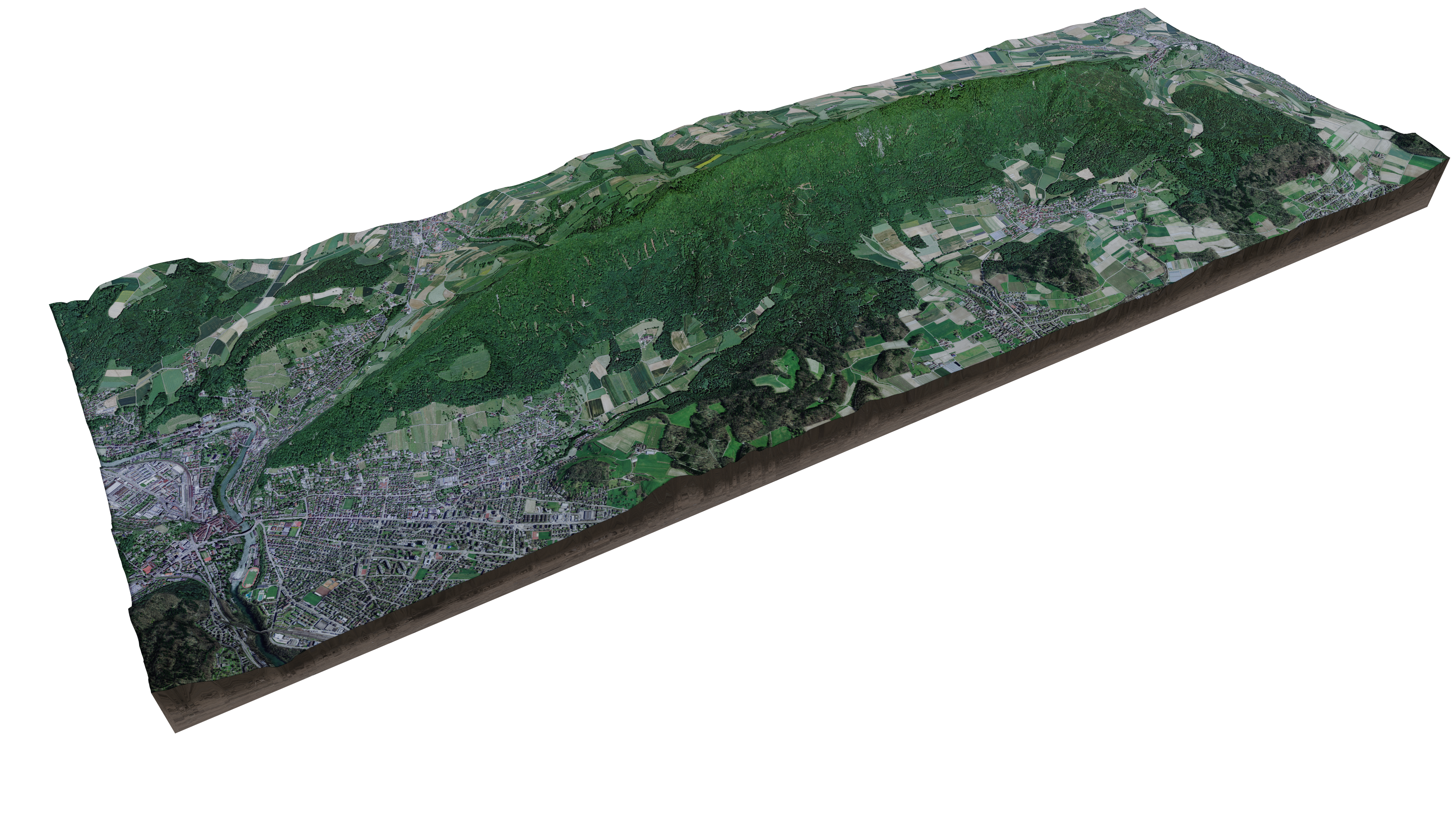
Our main site for developing this approach is the Lägern mountain range, with the core site being around the flux tower of ETH/WSL. An exemplary dataset acquired by terrestrial laser scanner on the site can be explored in full 3d.
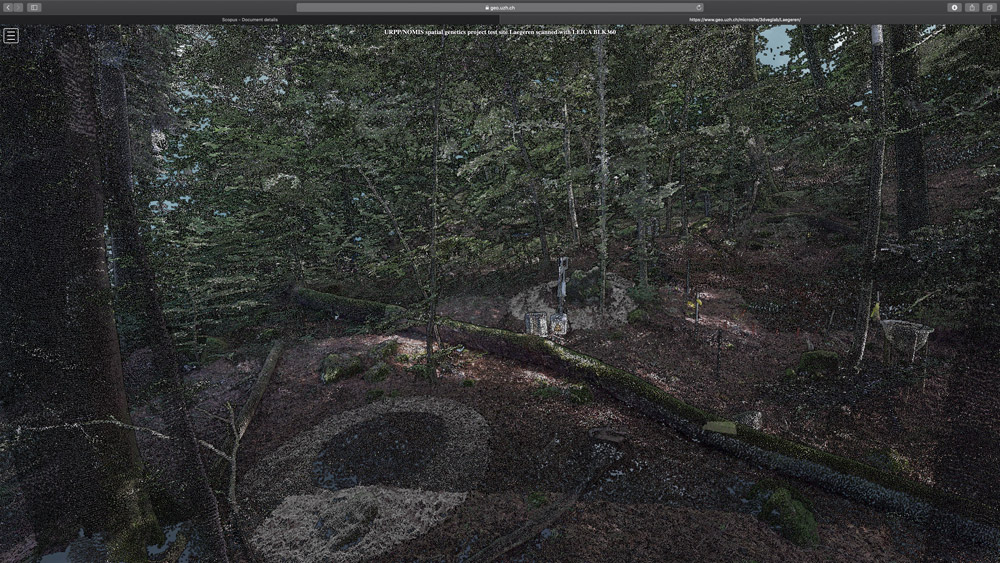
Such datasets look impressive, but are merely a collection of coloured 3d points, albeit a lot of them. Consequently, a large part of our research is to develop automated methods that convert the devoid-of-semantics point cloud to meaningful information. Such information, e.g. tree location or branch geometry can then be used to construct a virtual representation of the forest.
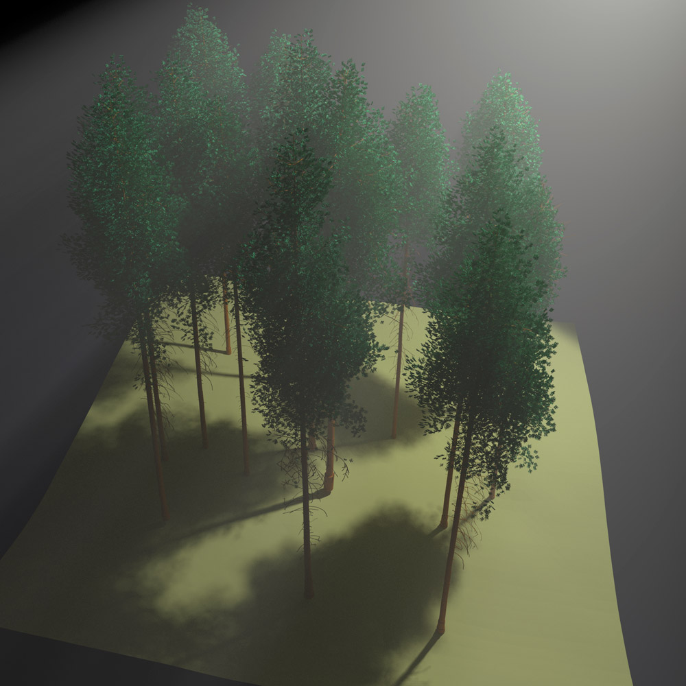
3d ray tracing - understanding the light regime in forest canopies
We then use this 3d representation in so-called radiative transfer models or ray-tracers, which simulate the light regime within the complex 3d forest canopy. We currently use these models two-fold:
i) to simulate other remote sensing datasets (e.g. satellite images) and to test information retrieval methods on those, as we know all details of our virtual forest and
ii) to increase our understanding on how structure and the light regime are linked to forest functioning.
The Laegeren site image and the virtual forest stand were created the open-source raytracing tool 'blender'.
Concluding, such RT modelling frameworks have the potential to prototype and validate future space-borne observation concepts that are aimed at informing variables of biodiversity, while the 3d remote sensing based morphological traits could complement other observational approaches and in-situ networks of diversity, providing effective spatiotemporal gap filling for a comprehensive assessment of changes in diversity.
More news
- #125: The 125th and last
- #124: Gletscher vor 125 Jahren und heute
- #123: Ist das Navi in der Hand der erste Schritt zum betreuten Wohnen?
- #122: Catapulted into a new world
- #121: How to make health care service provision more equitable and greener
- #120: Our world is a multidimensional collage
- #119: Is Tourism the Beginning or the End? Livelihoods of Georgian Mountain People at Stake
- #118: «Wir müssen den Klimawandel systematisch als Risiko mitdenken»
- #117: Andean mountain regions: Fragile sentinels of landscape and cultural transformation
- #116: Temporary streams at the doorsteps of Irchel Campus
- #115: Counting snowflakes from space
- #114: Provokation und Revolte am GIUZ
- #113: Ambitious goals for biodiversity urgently needed!
- #112: "The Eyes Have It!" - Where we look while navigating
- #111: Investigating plants genetic structure from above
- #110: «I see and I remember. I do and I understand.»
- #109: «Für uns, unsere Kinder und Kindeskinder»
- #108: Was macht die Digitalisierung mit unserer Umwelt?
- #107: The role of a developer at GIUZ
- #106: Dem unterirdischen Wasser auf der Spur
- #105: Was der Geographieunterricht zur Bildung im 21. Jahrhundert beitragen kann
- #104: Nepal - Kein Land für alte Leute?
- #103: Klimawandel in der Schweiz: Alles, was du wissen musst!
- #102: Wie Instagram unseren Umgang mit der Natur verändert
- #101: Numbed by navigation technologies: How can we counteract?
- #100: This is blog post number 100
- #99: Investigating food sustainability: from production and trade to consumption
- #98: Geographers live in concert - postponed!
- #97: Global Glyphosate: Uneven Geographies of herbicide production and use
- #96: "Pesticides burned grass and know-how"
- #95: Vier Standorte in 125 Jahren
- #94: Dietikon: Vom Bauerndorf zur Stadt
- #93: What is biodiversity?
- #92: Fieldwork in rural Nepal: reflection on positionality, responsibility, and roles
- #91: Das Schulfach Geographie: heute und morgen
- #90: Mapping functional diversity from space
- #89: Adieu ewig’ Eis
- #88: Landschaftsleistungen erlebbar machen
- #87: What is the role of variability in nature?
- #86: The Skin of Chitwan
- #85: Animated flight line collection over Switzerland
- #84: Space, Nature & Society: Wo wir forschen und was wir tun
- #83: Do you know about the 3MT competition?
- #82: An academic career in ecology
- #81: Hundreds of students enrich the start of the semester at the University of Zurich
- #80: Wie bewegen wir uns in Zukunft fort?
- #79: Willkommen im GEO- und ESS-Studium!
- #78: Expeditions from the window: How do you perceive your surroundings?
- #77: Researching a pandemic - during a pandemic
- #76: Das Geoteam stellt sich vor
- #75: How roots influence climate change
- #74: Imaging the earth from above
- #73: Studierende sammeln Daten: Natur, Landschaft und Ressourcen
- #72: Trouvaillen aus dem Archiv
- #71: The fluorescence of phytoplankton from 800 km above
- #70: Der kalte Norden ist auch familiär
- #69: How the COVID-19 pandemic is teaching us to tackle the climate crisis
- #68: Studierende sammeln Daten: Migration, Mobilität und Stadt
- #67: Summer break!
- #66: On the art of failing forward
- #65: Die Wasserstadt Zürich mit dem Smartphone entdecken
- #64: Tracing the tracks of the first Swiss polar explorers
- #63: Geistreiche Wortspiele
- #62: Von Gemüse über Milch bis zu Kaffee: Solawis in der Deutschschweiz
- #61: Berner Seeland - quo vadis?
- #60: Intense days on the field course to Val Piora
- #59: Panta rhei - everything flows
- #58: Comic Strip Geographies
- #57: Where we come from
- #56: A journey through time with loess deposits
- #55: Schlacht am Morgarten 1315: Wie sah die Landschaft damals aus?
- #54: Berne going green
- #53: Biochar increases rice root architecture
- #52: Cycling and pedestrian travel in Covid-19 world
- #51: The impact of Covid-19 from an economic geography perspective
- #49: Wenn das Eis fehlt: Das Lötschental und seine Zukunft
- #48: Planning ski tours: insights from Big Data
- #47: Is there a place for people in protected areas?
- #46: Biodiversity in Irchel park
- #45: Cress, tomatoes and the meaning of the universe
- #44: Scientific games to understand social-ecological system dynamics
- #43: Insight into the WGMS
- #42: Connecting female hydrologists worldwide: an initiative born at GIUZ
- #41: Shopping with Maximilian
- #40: Sars-CoV-2 and food producers: who cares?
- #39: The value of water
- #38: Mit Slimy-Masse die Gletscherschmelze illustrieren
- #37: Was machen Geographinnen und Geographen nach dem Studium?
- #36: Geographie-Student Jonathan, der Erdball und die CO2-Männli
- #35: Two study programs at the Department of Geography
- #34: Urban Sustainability as New Financial Fix?
- #33: Silently in the background
- #32: Interaktiv und interdisziplinär
- #31: Unpacking the complexity of social-ecological systems
- #30: Listen to the landscape
- #29: Creating synergies between homeschooling and university teaching
- #28: The first fully remote PhD defenses
- #27: Der Weltwassertag fällt ins Wasser
- #26: The GIUZ Sustainability Task Force
- #25: What is geography?
- #24: «Geografe nüme schlafe!»
- #23: Zurich on its way to the 2000-Watt society
- #22: Spatial genetics for plant-based communities - and much more!
- #21: Strebergärtli - Irchel Garden Project
- #20: Writing papers - a nightmare. Or not?
- #19: Urbanised landscapes - living between nature and civilisation
- #18: A 3D view on breathing forests
- #17: «Wir sind hier, wir sind laut!»
- #16: What is EGEA?
- #15: Exploring the future of biodiversity
- #14: Avalanche bulletins in the Alps: consistency across borders
- #13: Ice age coffee
- #12: Greenland 1912 - and today!
- #11: «Wir sitzen alle im selben Boot»
- #10: Air miles monitoring & reduction @ GIUZ
- #9: The "Geographie Alumni UZH" society: a platform for people interested in Geography
- #8: Knowledge in images - information design today
- #7: Geographie in Aufruhr
- #6: Glacier measurement series with mayonnaise
- #5: Landkarten im Reduit
- #4: Mapping the plastic soup
- #3: New unit "Space, Nature and Society"
- #2: How it all began
- #1: Happy 125th Anniversary