#30: Listen to the landscape
What is the contribution of sounds to the way people perceive landscapes? Using automatic text analysis methods, Olga Koblet tries to answer this question in her research.
Olga, tell me about your research.
We investigate how we can use text sources to automatically extract information about the landscape. We want to know how people perceive the sounds of the landscape. Because it's not only the amplitude and frequency of an acoustic signal that is crucial. For example, a jet engine and a waterfall produce similar sounds, but the one is considered annoying, the other beautiful.
Why is this important?
Policy makers need to know which places are important for people, for example for creating protected areas or for construction and road planning. So far, this information was gathered by doing interviews. This is time-consuming. Our method covers large spatial scales, and it can give priority to those mentions that appear multiple times. In this way it really generates added value.
And interestingly, we came across many unexpected contrasts in these text sources, such as places that are described as very quiet even though they are close to a big city. If these places are protected, a large number of people can benefit from such oases of calm. Think for example of Uetliberg. In this sense, it's a human-centered approach that we pursue.
Which texts did you analyze?
We use the descriptions of millions of georeferenced pictures that were collected within the Geograph project. For every square kilometre of Great Britain and Ireland, volunteers collected geographically representative photographs and added descriptions of these areas. That's an exceptional data set, and importantly, all the content is shared using Creative Commons Licenses. We did our analysis for the territory of British Isles.
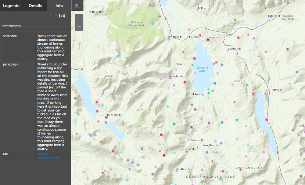
We also searched the internet for reports related to place names of the Lake District area, an area in Northwest England, to generate a text corpus independent of projects like Geograph. In the map you can see some results with extracted descriptions referring to sounds, smells and visual perception.
-
- Lake District perception
- Map of the Lake District with descriptions referring to sounds, smells and visual perception and an example description. Click on the picture to see more.
What will your next steps be?
We would love to apply our methods to texts from Switzerland, which in turn means dealing with texts not only in English, but also French, German and Italian.
Apropos languages: Your german is excellent. How did it happen that you came from Russia to Switzerland?
I studied geography in Moscow and then I decided to do my master's studies at ETH Zurich in geomatics, with a focus on remote sensing. Later I was part of the team developing Atlas der Schweiz at the Institute of Cartography and Geoinformation at ETH Zurich. This was an exciting time, since we did a lot of conceptual work. But at some point, it turned more into a production mode. Then I figured it would be great to do a PhD.
How did you come to this topic?
At the Institute of Cartography and Geoinformation, there was a project where several literary scientists together with cartographers were producing maps of the locations mentioned in different novels. It's called A Literary Atlas of Europe. These locations were extracted manually, and I wondered how well an automatic analysis of text would work. Nevertheless, after many discussions I decided to use texts with more geographical and practical relevance. That's how I came to my current project.
And besides work, what else are you interested in?
I love to read. I was always dreaming of having a job where I can read the whole day. Before you can get started with these automatic methods, you have to read and classify a lot of texts manually. So, it couldn't have been better for me!
And I play the violin in a large symphonic orchestra, that's a wonderful, but time-consuming hobby. Finally, I've been doing orienteering since I lived in Moscow. Maps are part of my life since I was a teenager.
Map of sound descriptions for the territory of British Isles
Geograph British Isles (crowdsourced project)
Koblet, Olga; Purves, Ross S (2020). From online texts to Landscape Character Assessment: Collecting and analysing first-person landscape perception computationally. Landscape and Urban Planning, 197:103757.
Chesnokova, Olga; Taylor, Joanna E; Gregory, Ian N; Purves, Ross S (2019). Hearing the silence: finding the middle ground in the spatial humanities? Extracting and comparing perceived silence and tranquillity in the English Lake District. International Journal of Geographical Information Science, 33(12):2430-2454.
Chesnokova, Olga; Purves, Ross S (2018). From image descriptions to perceived sounds and sources in landscape: Analyzing aural experience through text. Applied Geography, 93:103-111.
More news
- #125: The 125th and last
- #124: Gletscher vor 125 Jahren und heute
- #123: Ist das Navi in der Hand der erste Schritt zum betreuten Wohnen?
- #122: Catapulted into a new world
- #121: How to make health care service provision more equitable and greener
- #120: Our world is a multidimensional collage
- #119: Is Tourism the Beginning or the End? Livelihoods of Georgian Mountain People at Stake
- #118: «Wir müssen den Klimawandel systematisch als Risiko mitdenken»
- #117: Andean mountain regions: Fragile sentinels of landscape and cultural transformation
- #116: Temporary streams at the doorsteps of Irchel Campus
- #115: Counting snowflakes from space
- #114: Provokation und Revolte am GIUZ
- #113: Ambitious goals for biodiversity urgently needed!
- #112: "The Eyes Have It!" - Where we look while navigating
- #111: Investigating plants genetic structure from above
- #110: «I see and I remember. I do and I understand.»
- #109: «Für uns, unsere Kinder und Kindeskinder»
- #108: Was macht die Digitalisierung mit unserer Umwelt?
- #107: The role of a developer at GIUZ
- #106: Dem unterirdischen Wasser auf der Spur
- #105: Was der Geographieunterricht zur Bildung im 21. Jahrhundert beitragen kann
- #104: Nepal - Kein Land für alte Leute?
- #103: Klimawandel in der Schweiz: Alles, was du wissen musst!
- #102: Wie Instagram unseren Umgang mit der Natur verändert
- #101: Numbed by navigation technologies: How can we counteract?
- #100: This is blog post number 100
- #99: Investigating food sustainability: from production and trade to consumption
- #98: Geographers live in concert - postponed!
- #97: Global Glyphosate: Uneven Geographies of herbicide production and use
- #96: "Pesticides burned grass and know-how"
- #95: Vier Standorte in 125 Jahren
- #94: Dietikon: Vom Bauerndorf zur Stadt
- #93: What is biodiversity?
- #92: Fieldwork in rural Nepal: reflection on positionality, responsibility, and roles
- #91: Das Schulfach Geographie: heute und morgen
- #90: Mapping functional diversity from space
- #89: Adieu ewig’ Eis
- #88: Landschaftsleistungen erlebbar machen
- #87: What is the role of variability in nature?
- #86: The Skin of Chitwan
- #85: Animated flight line collection over Switzerland
- #84: Space, Nature & Society: Wo wir forschen und was wir tun
- #83: Do you know about the 3MT competition?
- #82: An academic career in ecology
- #81: Hundreds of students enrich the start of the semester at the University of Zurich
- #80: Wie bewegen wir uns in Zukunft fort?
- #79: Willkommen im GEO- und ESS-Studium!
- #78: Expeditions from the window: How do you perceive your surroundings?
- #77: Researching a pandemic - during a pandemic
- #76: Das Geoteam stellt sich vor
- #75: How roots influence climate change
- #74: Imaging the earth from above
- #73: Studierende sammeln Daten: Natur, Landschaft und Ressourcen
- #72: Trouvaillen aus dem Archiv
- #71: The fluorescence of phytoplankton from 800 km above
- #70: Der kalte Norden ist auch familiär
- #69: How the COVID-19 pandemic is teaching us to tackle the climate crisis
- #68: Studierende sammeln Daten: Migration, Mobilität und Stadt
- #67: Summer break!
- #66: On the art of failing forward
- #65: Die Wasserstadt Zürich mit dem Smartphone entdecken
- #64: Tracing the tracks of the first Swiss polar explorers
- #63: Geistreiche Wortspiele
- #62: Von Gemüse über Milch bis zu Kaffee: Solawis in der Deutschschweiz
- #61: Berner Seeland - quo vadis?
- #60: Intense days on the field course to Val Piora
- #59: Panta rhei - everything flows
- #58: Comic Strip Geographies
- #57: Where we come from
- #56: A journey through time with loess deposits
- #55: Schlacht am Morgarten 1315: Wie sah die Landschaft damals aus?
- #54: Berne going green
- #53: Biochar increases rice root architecture
- #52: Cycling and pedestrian travel in Covid-19 world
- #51: The impact of Covid-19 from an economic geography perspective
- #50: Why do we create virtual forests?
- #49: Wenn das Eis fehlt: Das Lötschental und seine Zukunft
- #48: Planning ski tours: insights from Big Data
- #47: Is there a place for people in protected areas?
- #46: Biodiversity in Irchel park
- #45: Cress, tomatoes and the meaning of the universe
- #44: Scientific games to understand social-ecological system dynamics
- #43: Insight into the WGMS
- #42: Connecting female hydrologists worldwide: an initiative born at GIUZ
- #41: Shopping with Maximilian
- #40: Sars-CoV-2 and food producers: who cares?
- #39: The value of water
- #38: Mit Slimy-Masse die Gletscherschmelze illustrieren
- #37: Was machen Geographinnen und Geographen nach dem Studium?
- #36: Geographie-Student Jonathan, der Erdball und die CO2-Männli
- #35: Two study programs at the Department of Geography
- #34: Urban Sustainability as New Financial Fix?
- #33: Silently in the background
- #32: Interaktiv und interdisziplinär
- #31: Unpacking the complexity of social-ecological systems
- #29: Creating synergies between homeschooling and university teaching
- #28: The first fully remote PhD defenses
- #27: Der Weltwassertag fällt ins Wasser
- #26: The GIUZ Sustainability Task Force
- #25: What is geography?
- #24: «Geografe nüme schlafe!»
- #23: Zurich on its way to the 2000-Watt society
- #22: Spatial genetics for plant-based communities - and much more!
- #21: Strebergärtli - Irchel Garden Project
- #20: Writing papers - a nightmare. Or not?
- #19: Urbanised landscapes - living between nature and civilisation
- #18: A 3D view on breathing forests
- #17: «Wir sind hier, wir sind laut!»
- #16: What is EGEA?
- #15: Exploring the future of biodiversity
- #14: Avalanche bulletins in the Alps: consistency across borders
- #13: Ice age coffee
- #12: Greenland 1912 - and today!
- #11: «Wir sitzen alle im selben Boot»
- #10: Air miles monitoring & reduction @ GIUZ
- #9: The "Geographie Alumni UZH" society: a platform for people interested in Geography
- #8: Knowledge in images - information design today
- #7: Geographie in Aufruhr
- #6: Glacier measurement series with mayonnaise
- #5: Landkarten im Reduit
- #4: Mapping the plastic soup
- #3: New unit "Space, Nature and Society"
- #2: How it all began
- #1: Happy 125th Anniversary