|
|
|
|
| A simple model to describe permafrost and glaciers is shown in figure 1. It shows the relation between permafrost distribution and continentality (precipitation): In humid-maritime regions with large temperate glaciers reaching low altitudes, permafrost occurence is restricted to non-ice-covered rockwalls. However, with increasing continentality, the lower permafrost limit sinks and the equilibrium line of glaciers rises, leading to extended periglacial belts. In zones of high continentality, permafrost development outweights glacierization and landforms develop which characterise the dry high mountain climatic zone. In particular, rock glaciers and ice-cored moraines form significant components of this landscape. |
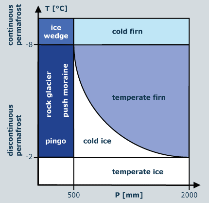 1 - Cryosphere scheme showing the distribution of glaciers and permafrost in relation to continentality |
|
As a function of temperature and precipitation the snow line increases with decreasing latitudes. The limit of the snow line is reached in the subtropical dry zones (Tibet, Altiplano: c. 6000m). The snow line and the distribution of the land surface together determine the main distribution and characteristics of glaciers and ice sheets. The prominant cold ice sheets of Antarctica (85.7%) and Greenland (10.7%) dominate in the areal distribution view. Of the rest of the total glacier area (3.6%, c. 550,000 km2) 2/3 is distributed on small ice caps, (mainly in dry areas with cold and polythermal ice in the Russian and Canadian Arctic and in the precipitation rich regions of Patagonia and Iceland with temperate ice caps. Only around 1% of the total area are mountain glaciers, mainly in the Gulf of Alaska and in the mountain ranges of Asia. |
|
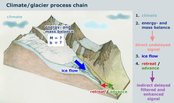
The dynamic interaction between climate and glacier is quite complex and can be characterized by the following process chain: |
|
2 - Scheme of the interaction between climate and glacier |
|
Large ice sheets actively influence
the global climate by air- and seawater circulation. Small, somewhat static, low-shear stress glaciers (cirque glaciers) have altitudinal extents comparable with the interannual variability of equilibrium-line altitude. They reflect yearly changes in mass balance almost immediately. Larger, dynamic, high-stress glaciers (mountain glaciers) react with enhanced amplitudes but a delay of several years to decadal fluctuations in climatic and mass-balance forcing. With a delay of several decades, the large valley glaciers in the Alps give strong, and efficiently smoothed signals of tongue reactions to cyclical trends. In fact, long glaciers such as Grosser Aletschgletscher have not had an advancing period since the 19th century. In contrast, smaller mountain glaciers such as Trient or Oberer Grindelwald showed two marked advancing periods in the 1920s and in the 1970/80s. The smallest glaciers like Pizol respond directly to annual mass balance and snow line variability through deposition/melting of snow/firn at the glacier margin. |
|
|
|
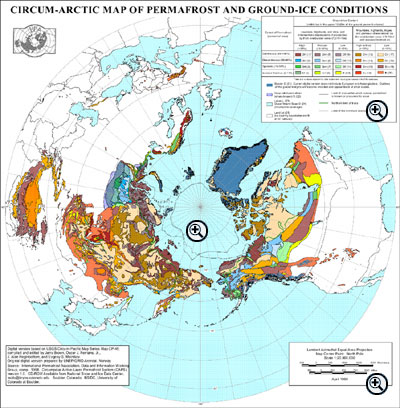
Worldwide, 25 million km2 of ground are permanently frozen. The permafrost distribution in the northern hemisphere can be seen in figure 3. According to the geographical regions where permafrost environments occur, a distinction between alpine (or mountain) permafrost and polar or high-latitude permafrost is made. Alpine permafrost is considered to be permafrost occuring at high altitudes and in rugged topography at middle and low latitudes. There are difficulties in using such definitions, however, since mountains also exist in polar regions. Areas of the world most widely underlain with permafrost are Alaska (85%), Russia (50%), Canada (45%) and China (20%). Continuous permafrost exists at a MAAT between –6°C to –8°C, discontinuous at a MAAT of 0°C to –1°C and sporadic even at a MAAT > 0°C (relict permafrost) or under special climatic conditions. |
|
Which kind of permafrost do you find in the Himalaya and in Greenland? |
||
|
3 - Distribution of permafrost in the northern hemisphere
(200K) |
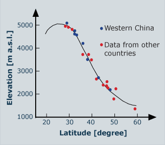
At latitudes lower than 60° the lower limit of permafrost distribution increases in altitude with decreasing latitude (Fig. 4). The maximum altitude of the lower limit of permafrost is reached in the dry subtropical mountain areas (c. 5000m). |
|
4 - Permafrost distribution in relation to latitude and altitude.
|
29 August 2011 |
||
| |
||