|
|
|
|
|
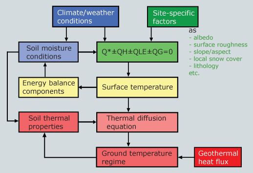
Atmospheric energy fluxes and the geothermal heat flux form the thermal boundary conditions for the existence of permafrost. While the geothermal heat flux is more or less constant (spatially and temporally), the atmosphere's heat deficit varies significantly in space and time. Local surface conditions (e.g. vegetation, snow) and subsurface layers (e.g. organic matter, coarse blocks with circulating air) act as buffers between the atmosphere (climate) and the deeper ground. This buffer sometimes causes a strong thermal offset between the MAGST and MAGT. As a consequence, the existence of permafrost depends on the combination of climate, microclimate (local/surface) and lithologic (subsurface) conditions. |
| At the interface of the atmosphere and the ground, factors such as the type of vegetation or depth and duration of snow-cover have a profound controlling influence on the surface temperature. Corresponding interactions of site-specific factors and climate produce the microclimate: net radiation depends on the albedo of the surface, longwave radiation loss depends on emissivity of the surface material, evaporation depends on the availability of water, sensitive heat flux is a function of wind speed and surface roughness, etc. (see figure 1) |
1 - Flow diagram of climate-ground thermal interactions |
|
How does a permafrost body develop? If changing climatic conditions cause a MAGST below 0°C, the depth of winter freezing will exceed the depth of the summer thaw. The layer of permafrost will thicken progressively downward with each succeeding winter and is stopped by the heat flow from the earth's interior. A geothermal gradient of about 30 K/km will have developed by the time an equilibrium condition of steady heat flow is reached. The base of the permafrost approaches an equilibrium depth, where the temperature increase due to the geothermal heat flux is equal to the cold coming from the surface temperature (see figure 4). Such an equilibrium temperature profile may need thousands of years to develop. |
|
Heat transfer processes occurring at the atmosphere/surface (snow-cover/vegetation) interface and within the buffer layer are complex, involving evaporation and transpiration by vegetation, shading effects of the vegetation canopy, lateral heat transport within a coarse-blocky surface layer, heat transport through the snow-cover and variable effects of the accumulation and persistence of snow-cover, etc. Such factors often override the influence of larger-scale macroclimatic factors on ground thermal conditions. Therefore, the MAGST usually differs by several degrees from MAAT. A general rule of thumb is: |
|
||||||
|
2 - Temperature measurements in a borehole at Murtal-Corvatsch, Switzerland at depths of 0.6m - 19.6m |
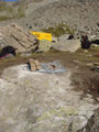 |
3 - Thermistor chain
in a borehole drilled in bedrock in the Corvatsch-Furtschellas area, Switzerland.
Photo: P. Blétry |
|
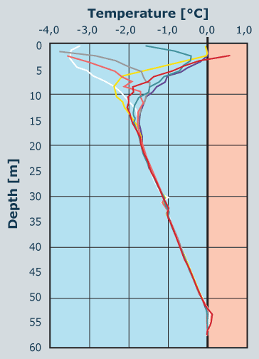
| 4 - Temperature
– depth profile of the Murtèl-Corvatsch borehole 2/1987. In
the diagram you can recognize the seasonal temperature variations (measured
data from different dates) in the top 20 m of the borehole until the depth
of ZAA. At a depth of 52m, seasonal variations caused by ground water flow
occur. Below this depth, temperatures are again negative. Source: Vonder Mühll and Haeberli (1990) |
29 August 2011 |
||
| |
||