New Paper: Challenges in Estimating Functional Diversity from Airborne Data

Biodiversity in Switzerland is in a worrying state. The Swiss Federal Office for the Environment (BAFU) warns that biodiversity will continue to decline and calls for decisive action. Effective conservation relies on robust monitoring data. This data makes it possible to identify endangered areas and prioritize conservation efforts.
Remote sensing methods, such as airborne and satellite-based observations, are increasingly used to monitor biodiversity across large areas. These methods often focus on identifying which species are present in a given region - a measure known as species diversity. This information helps identify species at risk of extinction or those threatening ecosystems as invasives.
To better understand how biodiversity contributes to ecosystem functioning, researchers have introduced the concept of functional diversity. It describes not only how many species exist in a specific area, but also how well they complement each other in their roles. For example, in a forest, different species vary in how they use resources and in how they contribute to processes such as carbon storage and water cycling. Monitoring this aspect of biodiversity enables researchers to assess the resilience and productivity of ecosystems.
However, accurately measuring functional diversity remains a challenge, as results can vary depending on how the data is collected and processed. During his PhD, Marius Vögtli examined how data processing methods and flight path geometry influence the estimation of functional biodiversity.
The challenges
Remote sensing data can be influenced by several factors. In the atmosphere, particles such as aerosols and water vapor scatter and absorb light. On the ground, terrain and surface properties affect how light is reflected. In addition, reflection changes with the angle of sunlight and the viewing direction. This directional variation is known as reflectance anisotropy, meaning that the same surface can appear differently depending on the relative positions of the sun and the sensor.
These atmospheric, topographic, and anisotropic effects introduce errors into remote sensing data. To reduce these errors, the data must be corrected during processing. Scientists use specific methods to achieve this. Atmospheric correction removes distortions caused by particles and gases in the air, while topographic correction accounts for the influence of landforms, like slopes and elevation, on light reflection. Anisotropy correction adjusts for differences in how surfaces scatter light based on viewing and lighting angles. Together, these steps help ensure that the data is as accurate as possible.
Flying over Lägeren forest
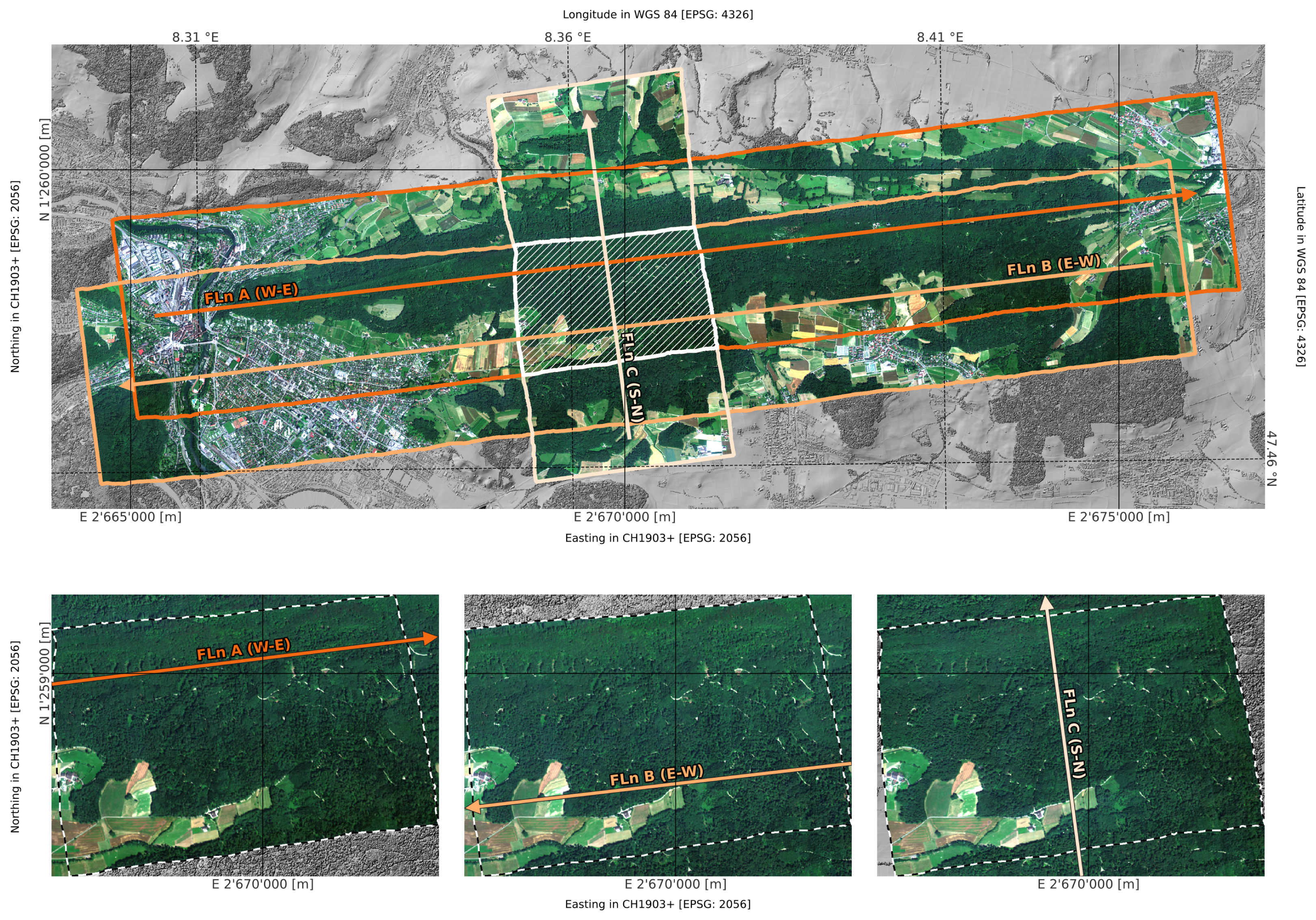
To test how robust functional richness estimates are, the researchers collected data over the Lägeren forest near Zürich by plane. They flew three consecutive flight lines within minutes of each other but from different directions. In doing so, they gathered data under slightly different observation conditions. The datasets were then processed in three different ways: first without any corrections (APP), then with atmospheric and topographic corrections (ATM), and finally with additional anisotropy corrections (BCR).
From the processed reflectance data, the researchers extracted three key plant traits: carotenoid content, chlorophyll levels, and leaf water content. These traits represent important aspects of plant health and ecological function. Based on these measurements, the team generated high-resolution maps of functional richness.
Accounting for shadows
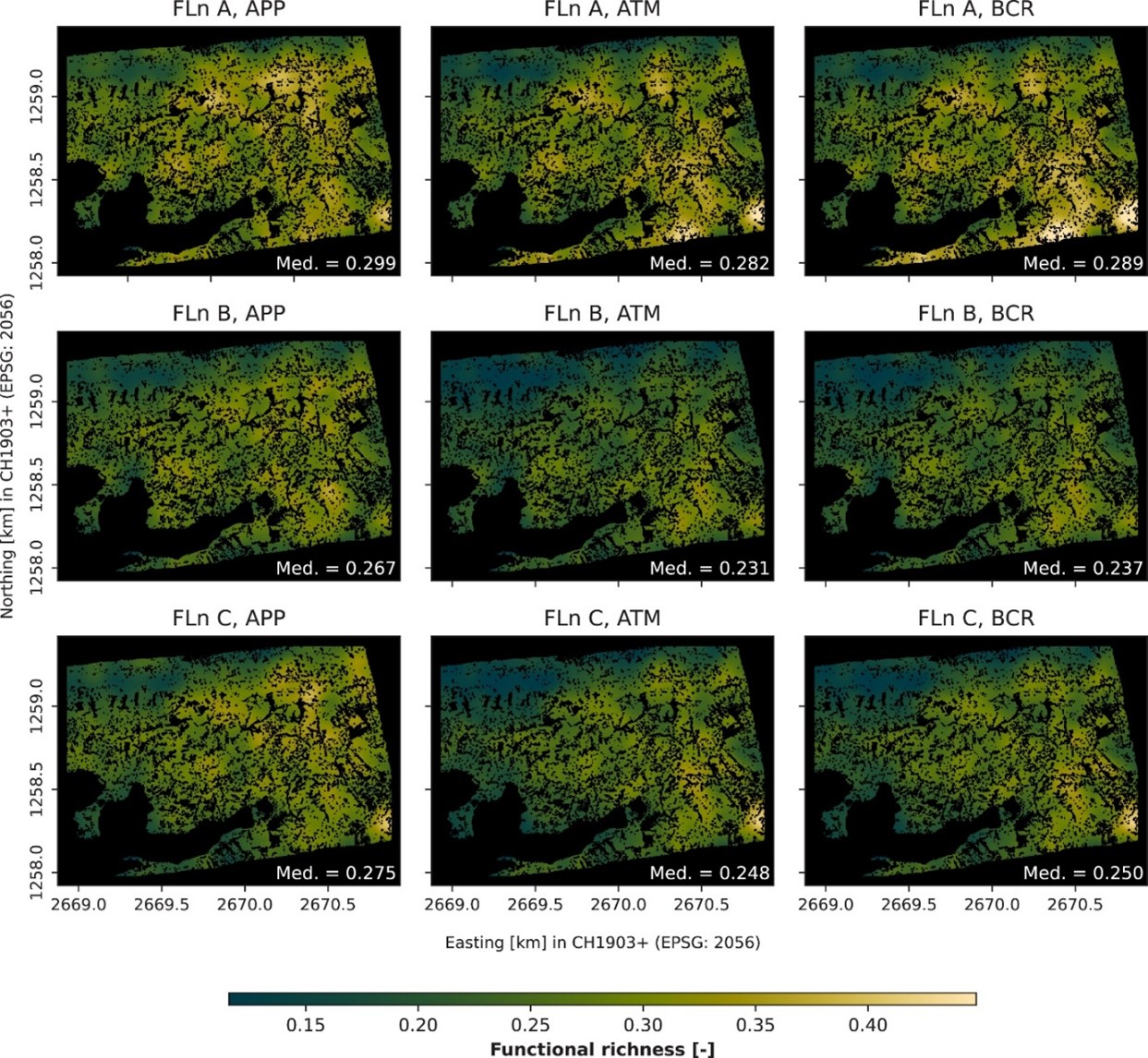
Comparing these maps revealed that the different processing steps significantly influenced the results. One of the study’s key findings was that uncorrected data can lead to substantial overestimation of functional richness. “If atmospheric, topographic, and anisotropy effects are not properly corrected, functional richness can be overestimated by up to 15 percent,” says Vögtli.
Even more striking, however, was the role of shadows. “At the beginning, our goal was to understand how different processing steps affect estimates of functional diversity. What we found, though, was that the existence of shadows can have an even stronger impact than the processing itself,” Vögtli explains.
These shadows are the result of cast by terrain or vegetation. Shaded areas receive less illumination, which alters their spectral signature. This can influence diversity estimates. Depending on the flight direction and the position of the sun, some flight paths recorded substantially more shadowed areas than others.
“In previous studies, shadows weren’t directly identified. Instead, the idea was to avoid them by only considering the brightest pixel in a certain area. But this approach doesn’t always work: if the whole area is in shadow, even the brightest pixel is still a shadow,” Vögtli explains. "So until now, it was unclear how many shadow pixels remain in the data, and what influence they have on the results.”
Implications for biodiversity monitoring
The study concludes that shadow effects must be carefully considered in future remote sensing applications. According to Vögtli, two approaches are possible: researchers can either account for shadows explicitly during data analysis or design flight paths that minimise shadow coverage from the from the outset.

“At present, there are few reliable methods to detect and correct shadow effects accurately. This makes careful flight planning all the more important.”
Dr. Marius Vögtli
Postdoctoral researcher, Remote Sensing Spectroscopy