Spatial genetics for plant-based communities - and much more!
You might be familiar with an increasingly common application of spatial genetics research: using people's DNA to identify their ancestry, for example as done by 23andMe or ancestry.com. Variable pieces of DNA are used to identify geographically located clusters.
-
- ancestral birth locations in North America
- Distribution of ancestral birth locations in North America associated with identity-by-descent clusters (Han, E., Carbonetto, P., Curtis, R. et al. Nat Commun 8, 14238, 2017. (CC BY 4.0))
In our research, we take a more classical definition of genetics as heritable traits. Spatial genetics is thus the spatially resolved analysis of heritable traits, their frequency and distribution in communities, and how this affects adaptation and community interactions. Spatial genetics research includes approaches from ecology, remote sensing, chemistry, genetics, and bioinformatics.
Projects in spatial genetics use two basic approaches, analogous to forward and reverse genetics.
- Combine established remote sensing techniques with genetic and chemical analyses, and determine the correspondence between variation in remotely sensed data, and genetic variation (due to variation in specific aspects of biochemistry and structure).
- Determine traits of interest and design targeted remote sensing approaches.
Focussing on plant-based communities
Our research at GIUZ focuses on the spatial genetics of plant-based communities. This is because plants are the trophic basis of terrestrial ecosystems, and their diversity structures ecological communities. Specifically, plant genetic and species-level diversity have large effects. We need to understand the underlying mechanisms, and to employ them to achieve e.g. conservation or sustainability goals, and to improve our projections of future habitats under climate change. A spatially explicit understanding of genetics and chemical signaling in plant communities is needed. We furthermore require methods for large-scale and long-term monitoring. Remote sensing technologies can provide spatiotemporally resolved, large-scale, long-term data.
Laegern forest as a key research site
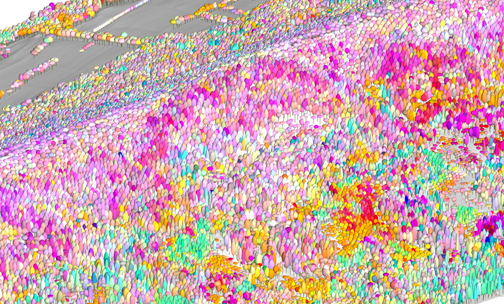
A key research site for us is the Laegern forest, which has been extensively mapped in terms of species and traits - and now, genotypes? Below is an image from work by Fabian Schneider, who mapped a part of the Laegern forest using a combination of laser scanning data for structure, and variation in imaging spectroscopy to identify differences among trees - but what causes those differences, and how much of it is genetic?
And by the way, spatially resolved genetic analyses also allow the visualization of the spread and evolution of the coronavirus HCoV-19.
-
- RemoteSensingRevealsForestBiodiversity-by-Schneider-Fabian
- Map of a part of the Laegern forest using laser scanning data and imaging spectroscopy (Image: Fabian Schneider)
More news
- The 125th and last
- Gletscher vor 125 Jahren und heute
- Ist das Navi in der Hand der erste Schritt zum betreuten Wohnen?
- Catapulted into a new world
- How to make health care service provision more equitable and greener
- Our world is a multidimensional collage
- Is Tourism the Beginning or the End? Livelihoods of Georgian Mountain People at Stake
- «Wir müssen den Klimawandel systematisch als Risiko mitdenken»
- Andean mountain regions: Fragile sentinels of landscape and cultural transformation
- Temporary streams at the doorsteps of Irchel Campus
- Counting snowflakes from space
- Provokation und Revolte am GIUZ
- Ambitious goals for biodiversity urgently needed!
- "The Eyes Have It!" - Where we look while navigating
- Investigating plants genetic structure from above
- «I see and I remember. I do and I understand.»
- «Für uns, unsere Kinder und Kindeskinder»
- Was macht die Digitalisierung mit unserer Umwelt?
- The role of a developer at GIUZ
- Dem unterirdischen Wasser auf der Spur
- Was der Geographieunterricht zur Bildung im 21. Jahrhundert beitragen kann
- Nepal - Kein Land für alte Leute?
- Klimawandel in der Schweiz: Alles, was du wissen musst!
- Wie Instagram unseren Umgang mit der Natur verändert
- Numbed by navigation technologies: How can we counteract?
- This is blog post number 100
- Investigating food sustainability: from production and trade to consumption
- Geographers live in concert - postponed!
- Global Glyphosate: Uneven Geographies of herbicide production and use
- "Pesticides burned grass and know-how"
- Vier Standorte in 125 Jahren
- Dietikon: Vom Bauerndorf zur Stadt
- What is biodiversity?
- Fieldwork in rural Nepal: reflection on positionality, responsibility, and roles
- Das Schulfach Geographie: heute und morgen
- Mapping functional diversity from space
- Adieu ewig’ Eis
- Landschaftsleistungen erlebbar machen
- What is the role of variability in nature?
- The Skin of Chitwan
- Animated flight line collection over Switzerland
- Space, Nature & Society: Wo wir forschen und was wir tun
- Do you know about the 3MT competition?
- An academic career in ecology
- Hundreds of students enrich the start of the semester at the University of Zurich
- Wie bewegen wir uns in Zukunft fort?
- Willkommen im GEO- und ESS-Studium!
- Expeditions from the window: How do you perceive your surroundings?
- Researching a pandemic - during a pandemic
- Das Geoteam stellt sich vor
- How roots influence climate change
- Imaging the earth from above
- Studierende sammeln Daten: Natur, Landschaft und Ressourcen
- Trouvaillen aus dem Archiv
- The fluorescence of phytoplankton from 800 km above
- Der kalte Norden ist auch familiär
- How the COVID-19 pandemic is teaching us to tackle the climate crisis
- Studierende sammeln Daten: Migration, Mobilität und Stadt
- Summer break!
- On the art of failing forward
- Die Wasserstadt Zürich mit dem Smartphone entdecken
- Tracing the tracks of the first Swiss polar explorers
- Geistreiche Wortspiele
- Von Gemüse über Milch bis zu Kaffee: Solawis in der Deutschschweiz
- Berner Seeland - quo vadis?
- Intense days on the field course to Val Piora
- Panta rhei - everything flows
- Comic Strip Geographies
- Where we come from
- A journey through time with loess deposits
- Schlacht am Morgarten 1315: Wie sah die Landschaft damals aus?
- Berne going green
- Biochar increases rice root architecture
- Cycling and pedestrian travel in Covid-19 world
- The impact of Covid-19 from an economic geography perspective
- Why do we create virtual forests?
- Wenn das Eis fehlt: Das Lötschental und seine Zukunft
- Planning ski tours: insights from Big Data
- Is there a place for people in protected areas?
- Biodiversity in Irchel park
- Cress, tomatoes and the meaning of the universe
- Scientific games to understand social-ecological system dynamics
- Insight into the WGMS
- Connecting female hydrologists worldwide: an initiative born at GIUZ
- Shopping with Maximilian
- Sars-CoV-2 and food producers: who cares?
- The value of water
- Mit Slimy-Masse die Gletscherschmelze illustrieren
- Was machen Geographinnen und Geographen nach dem Studium?
- Geographie-Student Jonathan, der Erdball und die CO2-Männli
- Two study programs at the Department of Geography
- Urban Sustainability as New Financial Fix?
- Silently in the background
- Interaktiv und interdisziplinär
- Unpacking the complexity of social-ecological systems
- Listen to the landscape
- Creating synergies between homeschooling and university teaching
- The first fully remote PhD defenses
- Der Weltwassertag fällt ins Wasser
- The GIUZ Sustainability Task Force
- What is geography?
- «Geografe nüme schlafe!»
- Zurich on its way to the 2000-Watt society
- Strebergärtli - Irchel Garden Project
- Writing papers - a nightmare. Or not?
- Urbanised landscapes - living between nature and civilisation
- A 3D view on breathing forests
- «Wir sind hier, wir sind laut!»
- What is EGEA?
- Exploring the future of biodiversity
- Avalanche bulletins in the Alps: consistency across borders
- Ice age coffee
- Greenland 1912 - and today!
- «Wir sitzen alle im selben Boot»
- Air miles monitoring & reduction @ GIUZ
- The "Geographie Alumni UZH" society: a platform for people interested in Geography
- Knowledge in images - information design today
- Geographie in Aufruhr
- Glacier measurement series with mayonnaise
- Landkarten im Reduit
- Mapping the plastic soup
- New unit "Space, Nature and Society"
- How it all began
- Happy 125th Anniversary