#115: Counting snowflakes from space
Do you like being active in the mountains? Are you a winter sports enthusiast? Or do you want to know how global warming affects water resources in Switzerland? Then you should have a look at the snow maps provided by ExoLabs, which are among the most accurate on the market.
-
- Picture: Adobe Stock / marchello74
ExoLabs is a spin-off from the Remote Sensing Laboratories @ GIUZ/UZH. Founded in 2017, it started with an innovative approach to map snow for the tourism market. Later, projects for insurances and federal offices followed. All projects have something in common: they are based on Earth observation (EO) data and the methods and algorithms used meet the highest scientific standards. Short: Science as a service. And this is also the motto of ExoLabs.
From science to business
Even if managing the scientific challenges is crucial to provide quality products and gain thrust in the community, mastering the financial challenges of a spin-off requires a different skillset. Winning customers in this area is not easy - especially if you lack a longstanding reputation. Therefore, the ExoLabs Team started from scratch by writing proposals and raising project funds from trusted entities. By now, they acquired grants from the European Space Agency, Innosuisse, the Swiss Space Centre and the European Union. This financial support enabled the further development of the products and to define a go-to-market strategy to win customers. And this has now been achieved this year, with first customers from the tourism and hydropower sectors. Although it is still a long way to go, the first steps have been taken.
Snow mapping - still a challenge
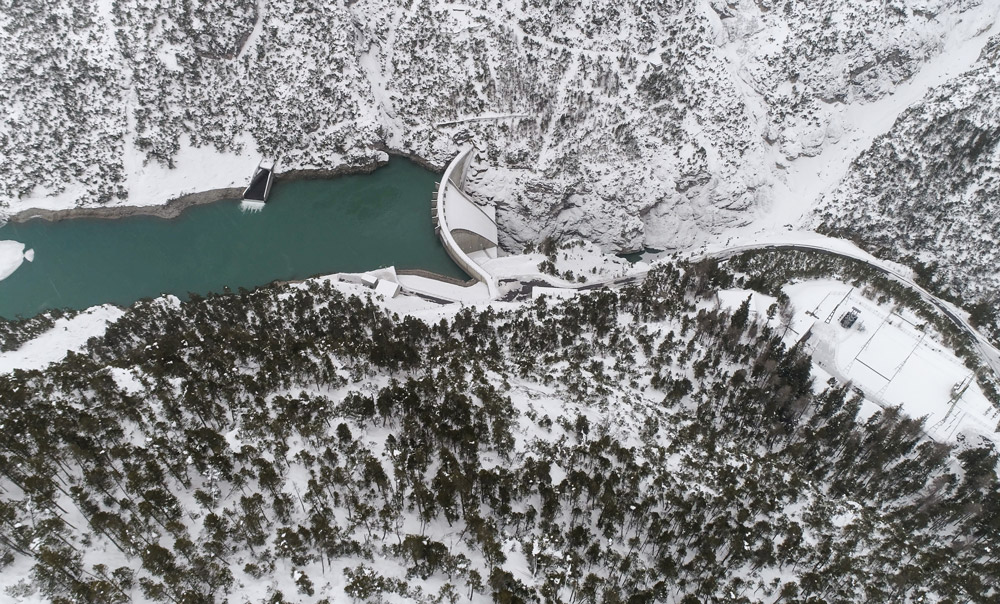
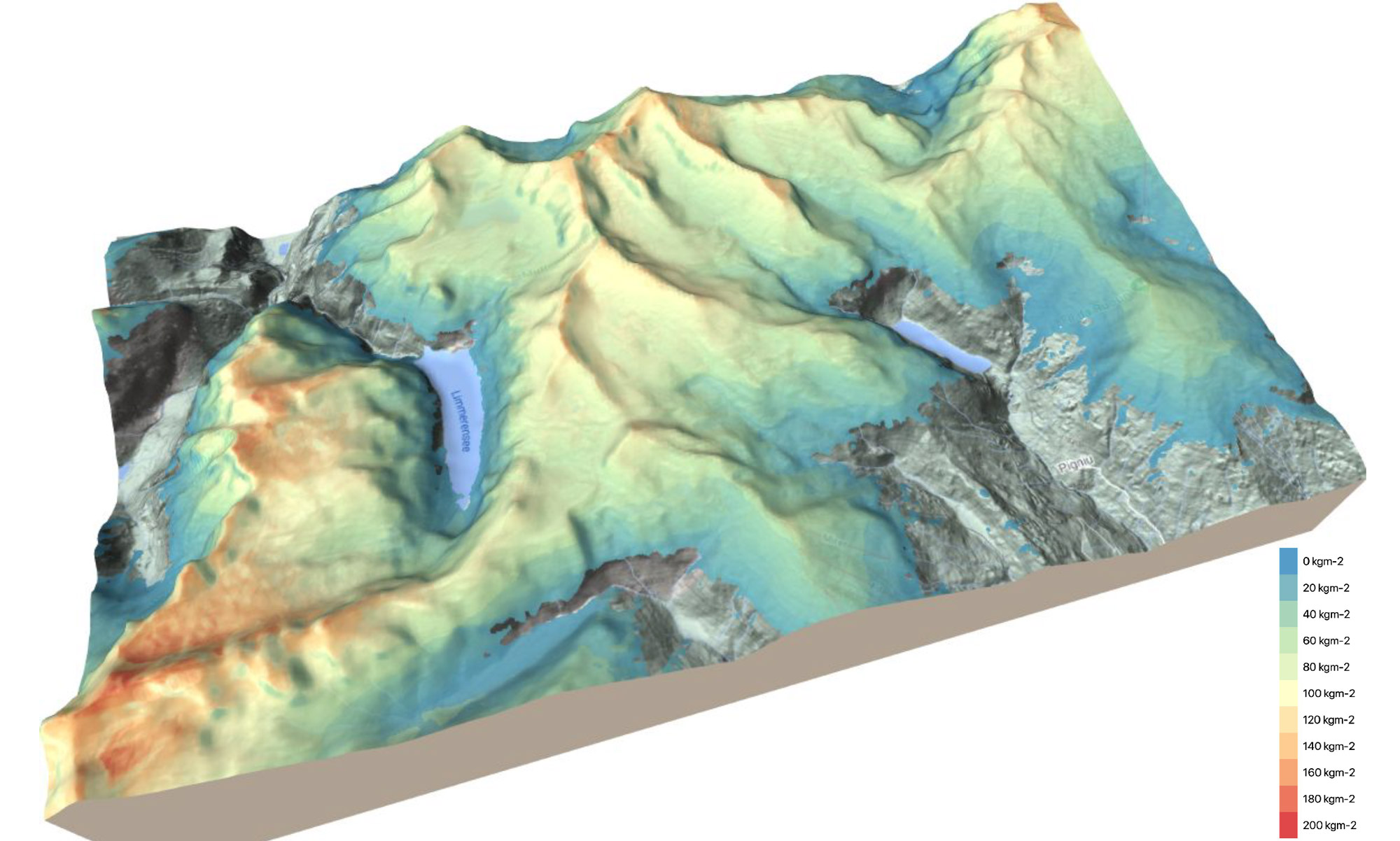
Snow is one of the so-called Essential Climate Variables (ECVs) and thus contributes significantly to the characterization of the climate and related changes. The variable snow can be further differentiated into the variables snow cover, snow height and snow water equivalent (SWE). The precise detection and characterization of those variables, however, is a major challenge due to their high temporal and spatial variability. This variability can only be reproduced to a limited extent with the existing approaches - whether in terms of spatial detail accuracy, the timeliness of the measurements or the reflection of topographic variations. In Switzerland, for example, the Institute of Snow and Avalanche Research (SLF) publishes snow depth maps approximately once per week in a 1 km spatial resolution.
Snow mapping 2.0
The snow portfolio offered by ExoLabs are based on acquisitions from several satellite missions and contains snow cover, snow depth and snow water equivalent for entire mountain ranges. The product development is supported, supplemented, and evaluated by data of in-situ monitoring networks, modelled weather data and additional information about topography, radiation balance and land cover. At the heart of all these products lies an automated workflow enabling a daily and spatially detailed (20x20 meters) monitoring of the snow package based on state-of-the-art machine learning algorithms. Being aware of our limitations, we collaborate with research partners at ETHZ and the WSL Institute for Snow and Avalanche Research SLF as well as with industry partners such as UBIMET and MetGIS (weather forecasts, Austria) or Think Outside (snow measuring equipment, Norway).
-
- Snow water equivalent
- Snow water equivalent around Limmerensee - daily updated with 20x20 meters pixel spacing
Snow for all
Although ExoLabs follows a classic business-to-business model, the visualization of the snow maps is still free of charge for every winter sports enthusiast. Have a look at our "ExoSnow" app - or use these snow maps in your next tour planning on the MountaiNow or Skitourenguru platforms. Have fun!
More news
- #125: The 125th and last
- #124: Gletscher vor 125 Jahren und heute
- #123: Ist das Navi in der Hand der erste Schritt zum betreuten Wohnen?
- #122: Catapulted into a new world
- #121: How to make health care service provision more equitable and greener
- #120: Our world is a multidimensional collage
- #119: Is Tourism the Beginning or the End? Livelihoods of Georgian Mountain People at Stake
- #118: «Wir müssen den Klimawandel systematisch als Risiko mitdenken»
- #117: Andean mountain regions: Fragile sentinels of landscape and cultural transformation
- #116: Temporary streams at the doorsteps of Irchel Campus
- #114: Provokation und Revolte am GIUZ
- #113: Ambitious goals for biodiversity urgently needed!
- #112: "The Eyes Have It!" - Where we look while navigating
- #111: Investigating plants genetic structure from above
- #110: «I see and I remember. I do and I understand.»
- #109: «Für uns, unsere Kinder und Kindeskinder»
- #108: Was macht die Digitalisierung mit unserer Umwelt?
- #107: The role of a developer at GIUZ
- #106: Dem unterirdischen Wasser auf der Spur
- #105: Was der Geographieunterricht zur Bildung im 21. Jahrhundert beitragen kann
- #104: Nepal - Kein Land für alte Leute?
- #103: Klimawandel in der Schweiz: Alles, was du wissen musst!
- #102: Wie Instagram unseren Umgang mit der Natur verändert
- #101: Numbed by navigation technologies: How can we counteract?
- #100: This is blog post number 100
- #99: Investigating food sustainability: from production and trade to consumption
- #98: Geographers live in concert - postponed!
- #97: Global Glyphosate: Uneven Geographies of herbicide production and use
- #96: "Pesticides burned grass and know-how"
- #95: Vier Standorte in 125 Jahren
- #94: Dietikon: Vom Bauerndorf zur Stadt
- #93: What is biodiversity?
- #92: Fieldwork in rural Nepal: reflection on positionality, responsibility, and roles
- #91: Das Schulfach Geographie: heute und morgen
- #90: Mapping functional diversity from space
- #89: Adieu ewig’ Eis
- #88: Landschaftsleistungen erlebbar machen
- #87: What is the role of variability in nature?
- #86: The Skin of Chitwan
- #85: Animated flight line collection over Switzerland
- #84: Space, Nature & Society: Wo wir forschen und was wir tun
- #83: Do you know about the 3MT competition?
- #82: An academic career in ecology
- #81: Hundreds of students enrich the start of the semester at the University of Zurich
- #80: Wie bewegen wir uns in Zukunft fort?
- #79: Willkommen im GEO- und ESS-Studium!
- #78: Expeditions from the window: How do you perceive your surroundings?
- #77: Researching a pandemic - during a pandemic
- #76: Das Geoteam stellt sich vor
- #75: How roots influence climate change
- #74: Imaging the earth from above
- #73: Studierende sammeln Daten: Natur, Landschaft und Ressourcen
- #72: Trouvaillen aus dem Archiv
- #71: The fluorescence of phytoplankton from 800 km above
- #70: Der kalte Norden ist auch familiär
- #69: How the COVID-19 pandemic is teaching us to tackle the climate crisis
- #68: Studierende sammeln Daten: Migration, Mobilität und Stadt
- #67: Summer break!
- #66: On the art of failing forward
- #65: Die Wasserstadt Zürich mit dem Smartphone entdecken
- #64: Tracing the tracks of the first Swiss polar explorers
- #63: Geistreiche Wortspiele
- #62: Von Gemüse über Milch bis zu Kaffee: Solawis in der Deutschschweiz
- #61: Berner Seeland - quo vadis?
- #60: Intense days on the field course to Val Piora
- #59: Panta rhei - everything flows
- #58: Comic Strip Geographies
- #57: Where we come from
- #56: A journey through time with loess deposits
- #55: Schlacht am Morgarten 1315: Wie sah die Landschaft damals aus?
- #54: Berne going green
- #53: Biochar increases rice root architecture
- #52: Cycling and pedestrian travel in Covid-19 world
- #51: The impact of Covid-19 from an economic geography perspective
- #50: Why do we create virtual forests?
- #49: Wenn das Eis fehlt: Das Lötschental und seine Zukunft
- #48: Planning ski tours: insights from Big Data
- #47: Is there a place for people in protected areas?
- #46: Biodiversity in Irchel park
- #45: Cress, tomatoes and the meaning of the universe
- #44: Scientific games to understand social-ecological system dynamics
- #43: Insight into the WGMS
- #42: Connecting female hydrologists worldwide: an initiative born at GIUZ
- #41: Shopping with Maximilian
- #40: Sars-CoV-2 and food producers: who cares?
- #39: The value of water
- #38: Mit Slimy-Masse die Gletscherschmelze illustrieren
- #37: Was machen Geographinnen und Geographen nach dem Studium?
- #36: Geographie-Student Jonathan, der Erdball und die CO2-Männli
- #35: Two study programs at the Department of Geography
- #34: Urban Sustainability as New Financial Fix?
- #33: Silently in the background
- #32: Interaktiv und interdisziplinär
- #31: Unpacking the complexity of social-ecological systems
- #30: Listen to the landscape
- #29: Creating synergies between homeschooling and university teaching
- #28: The first fully remote PhD defenses
- #27: Der Weltwassertag fällt ins Wasser
- #26: The GIUZ Sustainability Task Force
- #25: What is geography?
- #24: «Geografe nüme schlafe!»
- #23: Zurich on its way to the 2000-Watt society
- #22: Spatial genetics for plant-based communities - and much more!
- #21: Strebergärtli - Irchel Garden Project
- #20: Writing papers - a nightmare. Or not?
- #19: Urbanised landscapes - living between nature and civilisation
- #18: A 3D view on breathing forests
- #17: «Wir sind hier, wir sind laut!»
- #16: What is EGEA?
- #15: Exploring the future of biodiversity
- #14: Avalanche bulletins in the Alps: consistency across borders
- #13: Ice age coffee
- #12: Greenland 1912 - and today!
- #11: «Wir sitzen alle im selben Boot»
- #10: Air miles monitoring & reduction @ GIUZ
- #9: The "Geographie Alumni UZH" society: a platform for people interested in Geography
- #8: Knowledge in images - information design today
- #7: Geographie in Aufruhr
- #6: Glacier measurement series with mayonnaise
- #5: Landkarten im Reduit
- #4: Mapping the plastic soup
- #3: New unit "Space, Nature and Society"
- #2: How it all began
- #1: Happy 125th Anniversary