#48: Planning ski tours: insights from Big Data
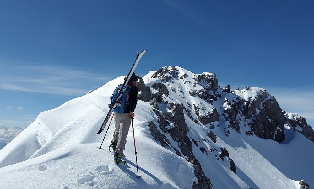
Recreationists planning backcountry ski tours often rely on web-based avalanche prevention platforms. The analysis of such data provides unique insights into human behaviour in avalanche prone terrain.
-
- Picture: Pixabay / Simon Steinberger
For a long time, avalanche research has focused on the geophysical aspects of avalanches, namely weather, terrain, and snow cover. The fourth aspect - the so-called human factor - was largely neglected. The human factor is not strictly defined but mostly described as a combination of risk propensity, misperceptions, attitude, pressure, and other aspects which influence decision-making processes.
The WSL Institute for Snow and Avalanche Research (SLF) possesses a large data set of planned backcountry ski tours, which was still largely unchartered territory. This data set was gathered from SLFs avalanche prevention platform, White Risk, which includes a map-based route planning tool. The planned routes can be downloaded on a mobile phone app and serve as a navigation support in backcountry terrain. The analysis of this data set has enabled gaining new insights into decision-making during the planning process of ski tours.
Analysing the decision-making process in thousands of planned ski tours
In the course of this master thesis the total of 150'000 planned tours from all over the Swiss Alps were filtered and processed. Many partial routes, routes outside of backcountry areas and generally unrealistic routes were removed from the data set. The remaining 56'000 routes were then analysed using methods from Computational Movement Analysis. These methods needed to be adapted to planned routes, as they do not entail a temporal dimension in contrast to typical movement data.
-
- Line density map
- Line density map of filtered routes in Swiss Alps using a search radius of 250m.
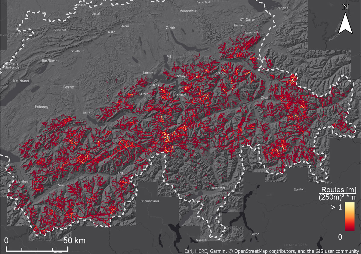
The results of this thesis reveal the favoured days and months for route planning and in which areas large numbers of tours are planned. These results correspond with the actual ski tours performed, as shown by another study (Techel et al., 2015), which analysed entries on social media platforms. Furthermore, a large share of the user-specified avalanche danger matched authoritative data from the SLF. This indicates adequate dealing with avalanche bulletins by most users during the planning process.
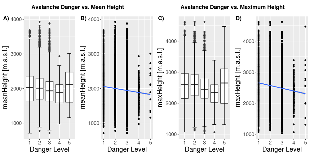
With increased avalanche danger, less steep routes are chosen
Additionally, the combination of user-specified avalanche danger with terrain attributes indicated that users adjust the planned routes according to the forecasted avalanche danger. For days with higher avalanche danger, less steep routes and less extreme terrain forms are chosen.
-
- height plot
- Impact of avalanche danger level on mean and maximum height of planned routes.
This work provides the first in-depth insights into the route planning behaviour of backcountry recreationists. The thesis has built the groundwork for further research and should therefore help to advance understanding of the human factor in avalanche processes and support the development of future prevention measures for avalanche accidents.
The approaches applied in this work are not solely applicable to planned ski tours but can also be used for different types of planned movement such as running, cycling, etc. Hopefully, this master thesis sets the starting point for further research on planned movement trajectories and opens up new avenues for scientific progress in various fields.
More news
- #125: The 125th and last
- #124: Gletscher vor 125 Jahren und heute
- #123: Ist das Navi in der Hand der erste Schritt zum betreuten Wohnen?
- #122: Catapulted into a new world
- #121: How to make health care service provision more equitable and greener
- #120: Our world is a multidimensional collage
- #119: Is Tourism the Beginning or the End? Livelihoods of Georgian Mountain People at Stake
- #118: «Wir müssen den Klimawandel systematisch als Risiko mitdenken»
- #117: Andean mountain regions: Fragile sentinels of landscape and cultural transformation
- #116: Temporary streams at the doorsteps of Irchel Campus
- #115: Counting snowflakes from space
- #114: Provokation und Revolte am GIUZ
- #113: Ambitious goals for biodiversity urgently needed!
- #112: "The Eyes Have It!" - Where we look while navigating
- #111: Investigating plants genetic structure from above
- #110: «I see and I remember. I do and I understand.»
- #109: «Für uns, unsere Kinder und Kindeskinder»
- #108: Was macht die Digitalisierung mit unserer Umwelt?
- #107: The role of a developer at GIUZ
- #106: Dem unterirdischen Wasser auf der Spur
- #105: Was der Geographieunterricht zur Bildung im 21. Jahrhundert beitragen kann
- #104: Nepal - Kein Land für alte Leute?
- #103: Klimawandel in der Schweiz: Alles, was du wissen musst!
- #102: Wie Instagram unseren Umgang mit der Natur verändert
- #101: Numbed by navigation technologies: How can we counteract?
- #100: This is blog post number 100
- #99: Investigating food sustainability: from production and trade to consumption
- #98: Geographers live in concert - postponed!
- #97: Global Glyphosate: Uneven Geographies of herbicide production and use
- #96: "Pesticides burned grass and know-how"
- #95: Vier Standorte in 125 Jahren
- #94: Dietikon: Vom Bauerndorf zur Stadt
- #93: What is biodiversity?
- #92: Fieldwork in rural Nepal: reflection on positionality, responsibility, and roles
- #91: Das Schulfach Geographie: heute und morgen
- #90: Mapping functional diversity from space
- #89: Adieu ewig’ Eis
- #88: Landschaftsleistungen erlebbar machen
- #87: What is the role of variability in nature?
- #86: The Skin of Chitwan
- #85: Animated flight line collection over Switzerland
- #84: Space, Nature & Society: Wo wir forschen und was wir tun
- #83: Do you know about the 3MT competition?
- #82: An academic career in ecology
- #81: Hundreds of students enrich the start of the semester at the University of Zurich
- #80: Wie bewegen wir uns in Zukunft fort?
- #79: Willkommen im GEO- und ESS-Studium!
- #78: Expeditions from the window: How do you perceive your surroundings?
- #77: Researching a pandemic - during a pandemic
- #76: Das Geoteam stellt sich vor
- #75: How roots influence climate change
- #74: Imaging the earth from above
- #73: Studierende sammeln Daten: Natur, Landschaft und Ressourcen
- #72: Trouvaillen aus dem Archiv
- #71: The fluorescence of phytoplankton from 800 km above
- #70: Der kalte Norden ist auch familiär
- #69: How the COVID-19 pandemic is teaching us to tackle the climate crisis
- #68: Studierende sammeln Daten: Migration, Mobilität und Stadt
- #67: Summer break!
- #66: On the art of failing forward
- #65: Die Wasserstadt Zürich mit dem Smartphone entdecken
- #64: Tracing the tracks of the first Swiss polar explorers
- #63: Geistreiche Wortspiele
- #62: Von Gemüse über Milch bis zu Kaffee: Solawis in der Deutschschweiz
- #61: Berner Seeland - quo vadis?
- #60: Intense days on the field course to Val Piora
- #59: Panta rhei - everything flows
- #58: Comic Strip Geographies
- #57: Where we come from
- #56: A journey through time with loess deposits
- #55: Schlacht am Morgarten 1315: Wie sah die Landschaft damals aus?
- #54: Berne going green
- #53: Biochar increases rice root architecture
- #52: Cycling and pedestrian travel in Covid-19 world
- #51: The impact of Covid-19 from an economic geography perspective
- #50: Why do we create virtual forests?
- #49: Wenn das Eis fehlt: Das Lötschental und seine Zukunft
- #47: Is there a place for people in protected areas?
- #46: Biodiversity in Irchel park
- #45: Cress, tomatoes and the meaning of the universe
- #44: Scientific games to understand social-ecological system dynamics
- #43: Insight into the WGMS
- #42: Connecting female hydrologists worldwide: an initiative born at GIUZ
- #41: Shopping with Maximilian
- #40: Sars-CoV-2 and food producers: who cares?
- #39: The value of water
- #38: Mit Slimy-Masse die Gletscherschmelze illustrieren
- #37: Was machen Geographinnen und Geographen nach dem Studium?
- #36: Geographie-Student Jonathan, der Erdball und die CO2-Männli
- #35: Two study programs at the Department of Geography
- #34: Urban Sustainability as New Financial Fix?
- #33: Silently in the background
- #32: Interaktiv und interdisziplinär
- #31: Unpacking the complexity of social-ecological systems
- #30: Listen to the landscape
- #29: Creating synergies between homeschooling and university teaching
- #28: The first fully remote PhD defenses
- #27: Der Weltwassertag fällt ins Wasser
- #26: The GIUZ Sustainability Task Force
- #25: What is geography?
- #24: «Geografe nüme schlafe!»
- #23: Zurich on its way to the 2000-Watt society
- #22: Spatial genetics for plant-based communities - and much more!
- #21: Strebergärtli - Irchel Garden Project
- #20: Writing papers - a nightmare. Or not?
- #19: Urbanised landscapes - living between nature and civilisation
- #18: A 3D view on breathing forests
- #17: «Wir sind hier, wir sind laut!»
- #16: What is EGEA?
- #15: Exploring the future of biodiversity
- #14: Avalanche bulletins in the Alps: consistency across borders
- #13: Ice age coffee
- #12: Greenland 1912 - and today!
- #11: «Wir sitzen alle im selben Boot»
- #10: Air miles monitoring & reduction @ GIUZ
- #9: The "Geographie Alumni UZH" society: a platform for people interested in Geography
- #8: Knowledge in images - information design today
- #7: Geographie in Aufruhr
- #6: Glacier measurement series with mayonnaise
- #5: Landkarten im Reduit
- #4: Mapping the plastic soup
- #3: New unit "Space, Nature and Society"
- #2: How it all began
- #1: Happy 125th Anniversary