3D-VegetationLab - a novel concept for land surface reference sites
Contact Persons
| Felix Morsdorf | |
| Michael Schaepman | Reik Leiterer |
Keywords
laser scanning, vegetation structure, radiative transfer, simulation, satellite imagery
Abstract
The up-coming generation of ESA operational missions – the Sentinels – will enhance the capability to observe the vegetated surfaces of the Earth. Nevertheless the quantitative interpretation of the Earth Observation (EO) signal is a challenging task because vegetation is a complex and dynamic medium. Effects of horizontal and vertical heterogeneities and asymmetrical structures of vegetation as well as their high temporal dynamics are often neglected in the algorithm development, calibration and validation procedures.
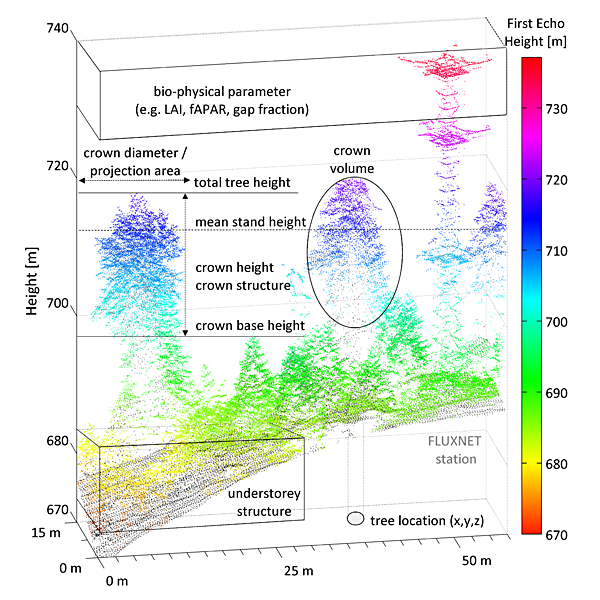
To better understand the scientific basis as well as the potential of future and upcoming missions we need detailed knowledge about the observed medium and the processes governing the radiative transfer. The combination of a realistic description of the medium in high detail together with a validated radiative transfer model will create a virtual lab mimicking reality which is capable to assess the potential of novel observation systems as well as to develop new algorithms and understand scaling issues from point measurements to the landscape. The advancement of ground based LiDAR systems now provides information that helps describing and reconstructing forest stands in 3D down to the leaf/shoot level. Such detailed representations of the canopy structure and the distribution of leaves/branches within a 3D radiative transfer model will thus allow the simulation of current and future missions in a controlled but realistic environment. It would thus offer an opportunity to test and develop dedicated applications to integrate EO into Earth system modeling.
The 3D-VegtationLab will develop a concept for land surface reference sites, which will be demonstrated for two selected pilot super-sites as a scientific support tool. The tool will include a standardized and comprehensive multi-temporal and multi-scale benchmark dataset together with a scientific toolbox based on a radiative transfer model. The 3D-Vegetation Lab will provide the scientific community with a common benchmarking tool to develop, validate and compare biophysical EO products from space-borne missions with special attention to prepare for upcoming Sentinels.
The 3D-VegetationLab is a 20 month project financed by ESA's STSE funding scheme, and partners are University College of London (UK), TU Wien (AUT), CESBIO Toulouse (FR) and Netcetera (CH).
You can find the project website with the software, data and results here