MSc Topics
Master students interested in writing a thesis in the field of Geochronology are welcome to approach us with their own suggestions. In addition to this, members of the Research Group regularly announce topics for possible master theses (see list below).
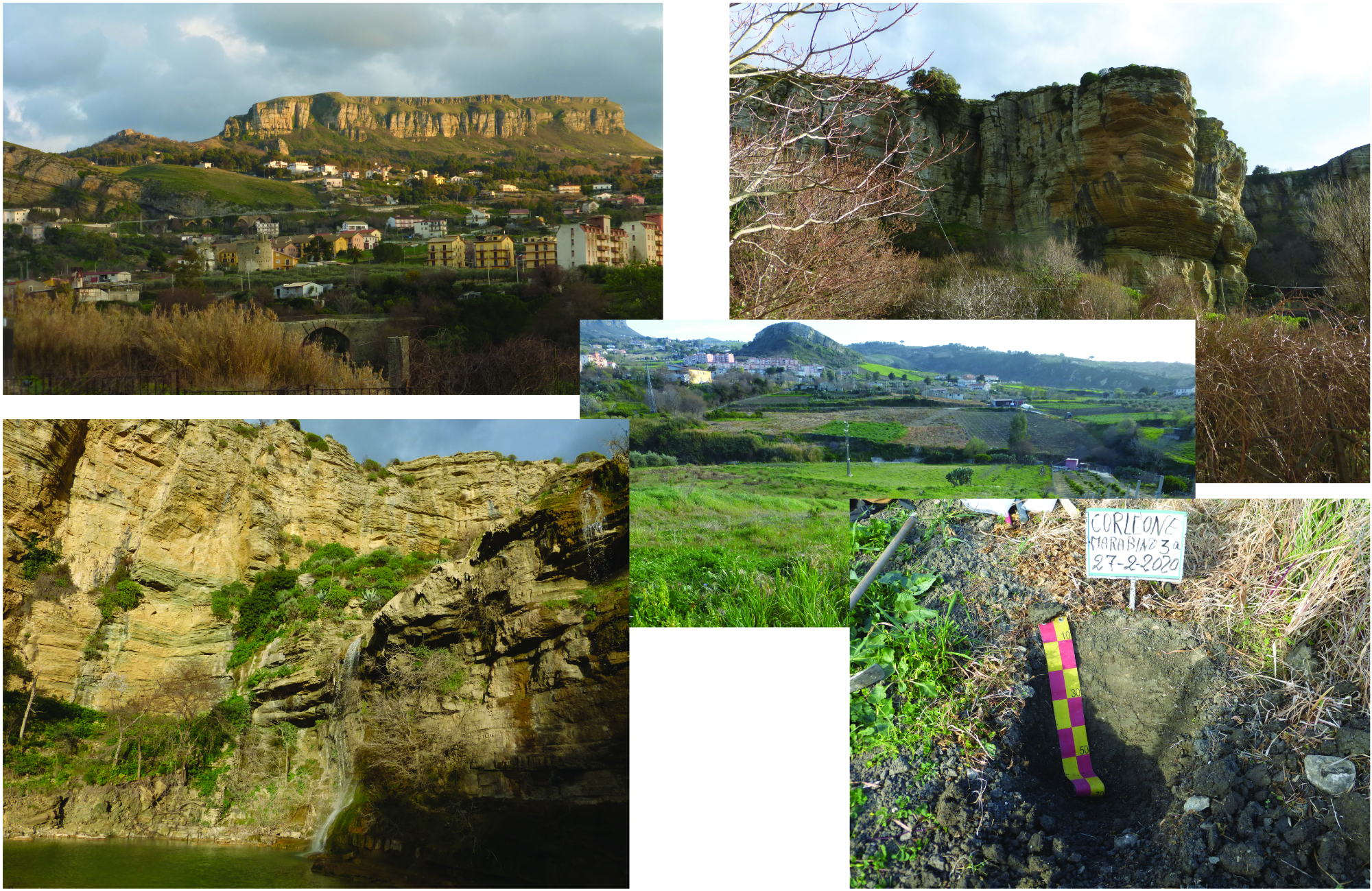
Tracing catchment-wide erosion using Pu- and 10Be-isotopes in a future UNESCO Geopark: long- vs short-term erosion
Within the context of the creation of a new UNESCO Geopark (Geopark delle Calcareniti Glauconitiche di Corleone), we have the unique possibility to provide basic knowledge about soils, landscape and related surface processes and to raise public awareness of these topics. The area around Corleone (north-western Sicily, Italy) consists of very peculiar geological conditions with its massive glauconitic calcarenites. The glauconite formation took place in an open-marine environment: the former home of the famous Megalodon.
The thesis shall address the following questions:
- How do long-term catchment-wide denudation rates compare to short-term rates and how are they related to the different lithologies?
- How are (shallow)landslides related to soil properties and overall denudation rates?
See Flyer: MSc thesis description (PDF, 5 MB)
Further information: Prof. Markus Egli
The thesis can start anytime and will be supervised by:
Prof. Dr. Markus Egli (University of Zurich),Prof. Edoardo Rotigliano (University of Palermo, Italy) and Prof. Salvatore Raimondi (University of Palermo, Italy)
Soil evolutional trajectories and carbon sequestration on Flysch in a future UNESCO Geopark
Within the context of the creation of a new UNESCO Geopark (Geopark delle Calcareniti Glauconitiche di Corleone), we have the unique possibility to provide basic knowledge about soils, landscape and related surface processes and to raise public awareness of these topics.
The aims of this MSc thesis are:
- to investigate soil profiles on Flysch in the surroundings of Corleone with respect to their weathering status, organic matter stocks and organic matter fractions
- to relate the organic C fractions and major C-compounds to weathering products such as Oxyhydroxides
- to derive a heuristic model of soil evolutional trajectories and carbon sequestration
See attached flyer (PDF, 5 MB) for MASc description
The thesis can start anytime and will be supervised by:
Prof. Dr. Markus Egli (University of Zurich), Prof. Edoardo Rotigliano (University of Palermo, Italy) and Prof. Salvatore Raimondi (University of Palermo, Italy)
Further information: Prof. Markus Egli
UNESCO Geopark in Corleone (Sicily): Tracing past living conditions using geoarchaeological techniques
Corleone's past is linked to a rather dark history. But things have been changing rapidly. The picturesque town on a plateau between the Monti Sicani to the south and Palermo to the north is surrounded by a spectacular landscape. Besides the landforms, also the geology has specific peculiarities; i.e., the glauconitic calcarenite. The municipality together with the Rotary Club and the UNESCO office in Palermo intend to establish a UNESCO Global Geopark in this region. Basic scientific data about the local to regional soils are missing. The planned MSc thesis will contribute to establishment of urgently needed data that are needed for the application process of the Geopark.
The Montagna Vecchia has been a settlement in the past (from the Middle Ages to several millennia ago). We will try to trace the living condistions particularly around teh Hellenistic period by analysing the soils specifically for phosphorous, carbon isotopes, n-alkanes, fatty acids, polycyclic aromatic hydrocarbons, charcoal and radiocarbon dating.
A collaboration with the University of Palermo (Prof. Salvatore Raimondi) is given.
See Flyer (some pictures): Corleone_landscape (JPG, 6 MB)
Further information: Prof. Markus Egli
Quantifying Surface Denudation and Erosional Processes in the Central Highlands of Madagascar
The Central Highlands of Madagascar host some of the most striking erosional features in the tropics, with thick lateritic regolith mantling low-relief plateaus and steep hillslopes dissected by “lavaka” (meaning 'hole' in Malagasy), amphitheater-shaped gullies. The MSc thesis has the following aims:
1. Quantify long-term regolith denudation rates on soil-mantled hillslopes.
2. Quanmtify chemical weathering
3. Develop a conceptual model of landscape evolution for the Central Highlands.
This project will be in collaboration with
Dr. Romano Clementucci (ETH Zürich; rclementucci@eaps.ethz.ch)
Dr. Negar Haghipour (ETH Zürich; negar.haghipour@eaps.ethz.ch)
Prof. Sean Willett (ETH Zürich; swillett@eaps.ethz.ch)
Further information: Prof. Markus Egli
Temporal evolution of surface (soil) denudation during the Holocene and Pleistocene; Wind River Range (Rocky Mountains)
How the landscape surface has been shaped over last about thousands of years, how soil erosion rates evolved over time and how these processes correlate with climate is a matter of debate. The Wind River Range (Rocky Mountains, USA) offers optimal conditions to study erosion rates over time by analysing the surface age of tors (large free-standing rock outcrop that is in contact with bedrock) and surrounding soils. Supervisors of the thesis are Prof. Dennis Dahms (Northern University of Iowa) and Prof. M. Egli.
Prof. Markus Egli
Automated image analysis of mineral soil properties. Can soil field survey be assisted by deep learning?
Further information: Prof. Markus Egli
Landscape evolution of the Schlappintal (canton of Grisons)
With the continuous development of dating techniques (e.g., 10Be), the extent of glaciers and related spatial variations since the Late Pleistocene is now partially rewritten. The Schlappintal (close to Klosters) offers a nice suite of moraines and boulders that enable the dating of glacial stades and the reconstruction of the landscape since the LGM.
Prof. Markus Egli