ALPECOLE
_
Dynamics of subalpine forests

Human impact, silviculture, animal disturbance


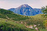
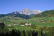
Most mountain forests of the world have been exploited since Middle Ages or earlier. In the Alps, for example the subalpine forests have longe been affected by clearcutting and other methods of use (grazing, alpine pastures, domestic lifestock). Secondary plant successions may inhibit forest dispersal and rejuvenation (tall perennial herbs and grasses, e.g. Calamagrostis villosa (shaggy woodreed). Furthermore, the impact on trees caused by game (browsing, animal disturbance) should be mentioned.

Possible indicators of former natural tree limits are:

  1. relict trees far above the actual tree limit
  2. subfossil trunks in peat bogs
  3. tree stumps and trunks above the actual forest limit still bearing marks of chopping and cutting
  4. pollen and macrofossils found in peat bogs close to the potential natural tree limit
  5. traditions and ancient field names indicating areas that have been previously forested
  6. forest plants such as Luzula sylvatica (greater woodrush), Clematis alpina (Alpine virgin's-bower) and Pyrola minor (common wintergreen). They can be used as potential forest indicators.

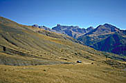
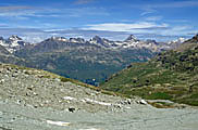
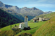
Potentially the natural forest limits in the Swiss Alps are: Prealps c. 2000m, Central Alps c. 2200 - 2400m, Southern Alps c. 2000 - 2200m. The highest position in the Central Alps is caused through the Massenerhebungseffekt (mass elevation effect). But there are certain landscapes of the earth which have still not been anthropogenically influenced, e.g. the Argentinean Huapi National Park, the west coast of the Southern island of New Zealand (Westland) and some steep fjords of the Norwegian coast where the forests reach up to the tree limit as closed boundary. Dense forests regarded as very close to a natural state and reaching high altitudes have even been found in the Swiss, Italian and Austrian Central Alps (e.g. Sertig valley, Kauner valley, Matsch valley, Radurschel valley).


Haute Provence 1 Alp Gesero 2 Seebenalp 3 Piz Corvatsch 4 Southern Tyrol 5 Avers Valley 6 Alp Nadels 7 Val Müstair 8


Captions
  1. Totally deforested area of the Col de Vars pass area (Haute Provence, France). Photo: C. Burga (120K)
     
  2. Alpine pasture within the subalpine Picea abies (Norway spruce) / Larix decidua (European larch) forest, showing impact by livestock trampling with extended stands of Rhododendron ferrugineum (Alpine rose) and European larch regeneration on disturbed sites (Alpe Gesero, 1750m, Ticino, Switzerland). Photo: C. Burga (149K
     
  3. Anthropogenically lowered Picea abies (Norway spruce) forest limit and natural forest limit on the opposite valley side facing the Churfirsten mountains (Seebenalp, 1820m, Canton of Saint Gallen, Switzerland). Photo: C. Burga. (146K)
     
  4. Distroyed vegetation cover from the upper tree limit to the alpine zone (skiing ground at Piz Corvatsch, 2700m, Grisons, Switzerland). Photo: C. Burga (120K)
     
  5. Cleared woodland for settlements (Southern Tyrol, 1500m, Italy). Photo: C. Burga (115K)
     
  6. Cleared woodland for settlements (Avers valley, 2000m, Grisons, Switzerland). Photo: C. Burga (133K)
     
  7. Anthropogenic upper Picea abies (Norway spruce) forest limit showing a dense belt of Alnus viridis (green alder), subalpine dwarf shrubs and single trees (Alp Nadels, 1920m, Grisons, Switzerland). Photo: C. Burga (161K)
     
  8. Former Picea abies (Norway spruce) / Larix decidua (European larch) forest anthropogenically modified into open larch forest used as pasture ("Lärchwiese") (Val Müstair, 1700m, Grisons, Switzerland). Photo: C. Burga (188K)


upback to topup

29 August 2011
© ALPECOLe 2002-2007