Urban Obesity

Urbanisation and Obesity rates of the world in comparison through a Shiny app.

About our Project

Background

Since 1975, worldwide obesity has nearly tripled (WHO 2018). What are the reasons for this development? An article of the Canadian Broadcasting Corporation pointed out that it is a “commonly held perception that obesity is a city problem” (CBC 2019). In the same time period, in which we could detect a rise in the obesity rate, the urbanisation rate has increased as well. 55% of the human population is living nowadays in urban areas. By the year 2050, this number will increase to 68% (UN 2018). Of course, this does not necessarily mean, that there is a relationship between the rises of the two rates. Nonetheless, it leads us to the following hypothesis:

Hypothesis

Our hypothesis is that the higher the degree of urbanization the higher is the obesity/overweight rate of a country. More and more people are seeking well paid jobs in cities as time progresses. Urbanisation is when people from the countryside move to cities or agglomerations. The ratio of people living in cities increases from year to year.

Our assumption is that countries with a high urbanization rate, also have more obese adults. To show the results, we created a Shiny app.
Obesity is defined with having a BMI of over 30. Food is easier and more abundant available in cities. This includes healthy as well as unhealthy foods, such as fast food.

Data

All datasets used for the map are from the WHO.

Map

We want to visualize the worldwide urbanisation and obesity rate and find out if our assumption of a correlation is correct. Our map is supposed to show the correlation between obesity and urbanization.

Max obesity rate
Country: Nauru
Min obesity rate
Country: Vietnam
Max urbanisation rate
Country: Singapore, Monaco, Nauru
Min urbanisation rate
Trinidad and Tobago

MAP

Instruction

On top the different years are shown. You may choose which year should be displayed, by clicking on it. The sliders on the bottom can be used to restrict the countries shown which are within the chosen range of obesity rate. Zoom buttons have been added to further inspect the data. By clicking on a country, a popup appears showing the country's name and both rates for the specific country.

Discussion

The map does not show a clear correlation between the obesity rates and the urbanisation rates of the countries. In the following animated figure, the obesity rates are plotted against the urbanisation rates for each country. The plot of 1980 seems to show a light correlation. This correlation seems to become less strong during the next decades.

plot_data

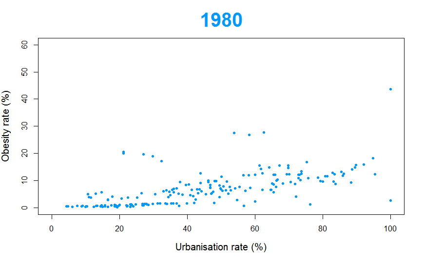
It has to be pointed out clearly that we did not test this possible correlation on its statistical significance. This should be done in a further study. Moreover, it should be tested if the correlation is based on causality.
Even though, we do not have a statistically useful result, we can at least say that our findings are congruent to those found in literature: A study shows that in 1985, in three quarters of the countries studied people in urban areas had higher BMIs than people in rural areas (CBC 2019). “But 30 years later, the BMI gap between urban and rural dwellers in many countries had shrunk dramatically, or even reversed” (ibid.).
In rural areas the mean BMI increased by 2.1 between 1985 and 2017, whereas in urban areas, it only increased by 1.3 (women) or 1.6 (men) (ibid.).

Useful Links

The data used was taken from the World Health Organisation (WHO), and for learning to start writing HTML5 W3School was used. General information about the course can be found under the rubric COURSE INFORMATION.

Obesity (WHO)

Prevalence of obesity among adults, BMI ≥ 30, crude
Estimates by country


Read More

Urbanisation (WHO)

Population living in urban areas in percentage
Data by country


Read More

Course Information

GEO 878 Geovisualisation
ECTS 3
Target Groups: Geography Masters students


Read More

Our Staff

We are Hans and Marius and we are thriving to become Geovisualisation-pros.

Hans Arnet

Hans Arnet

Co-Author, Lead Shiny App Developer

Hans did his Bachelor in Geography at the Universtiy of Bern. As of May 2019 he is studying at the University of Zurich his Master in Geography with focus on GIS.

Moon Moon

Moon Moon

Mascot, Lead Mental Supporter

Unfortunately we have never met him. He always called in sick whenever he should have been here to support us. Luckly we've got a picture of whim, which captures his essence perfectly.

Marius Lechtenboehmer

Marius Lechtenböhmer

Co-Author, Lead Website Developer

Marius studied Cultural Anthropology and Geography for his Bachelor in Basel. For his Master he is now doing a specialized Master of Geography in GIScience at the University of Zurich.

Troubles understanding?

For questions about the source code of the website, please contact the Lead Website Designer.

Get in touch with Marius


For questions about the Shiny app, please contact the Lead Shiny App Designer

Get in touch with Hans