Navigation auf uzh.ch
Navigation auf uzh.ch
Here are some services provided by RSL.
The NPOC is a public service, initiated by the Swiss State Secretariat for Education and Research. The NPOC offers scientific consulting in the field of remote sensing for Swiss authorities, research agencies, commercial providers and end-users to foster the use of earth observation. NPOC is a joint venture shared by the Remote Sensing Laboratories (RSL) at the Univ. of Zurich and the Federal Office of Topography (swisstopo).
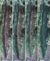
APEX - Airborne Prism Experiment
The APEX (Airborne Prism Experiment) sensor is an airborne imaging spectrometer operated by VITO and the Remote Sensing Laboratories, University of Zurich. Interested researchers and institutions are invited request APEX flights over their test sites. For questions or a quotation get in touch the APEX team via the contact form.
ARES - Airborne Research of the Earth System
ARES is a new airborne infrastructure that is currently under development. Please visit the ARES webpage to learn more about the current status. APEX and AVIRIS-ng sensors are currently operated in the framework of ARES while the native ARES sensor systems are being acquired and implemented.
SPECCHIO - Spectral Information System
SPECCHIO is a spectral information system designed to hold reference spectra and spectral campaign data obtained by spectroradiometers. The inclusion of a rich metadata set in the data model ensures the longevity of spectral data and enables the sharing of spectral data between research groups.
RSL operates an online database featuring more than 100’000 spectra. Please use the SPECCHIO online portal to access these spectra or download the SPECCHIO Java Client for more complex interactions, including uploading your own spectra.
Download the SPECCHIO virtual machine to install the full SPECCHIO system on your own machine or server.
Learn about how to directly access SPECCHIO from Matlab, R or Phyton by working through the tutorials.
Conference List
The Conference List indicates conferences, symposia, and workshops which have topics related to remote sensing in their programm. The list is sorted by date of event.