Navigation auf uzh.ch
Navigation auf uzh.ch
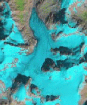
The quantitative determination of glacier changes and glacier specific products (e.g. their annual mass balance or thickness distribution) requires a baseline dataset of their extent being available. Such information can be obtained with semi-automated methods over large regions using multispectral satellite data. With the huge archives of satellite data being freely available today, glacier changes can now be followed for a >30 years period.
Our research group is developing methods for most efficient mapping of glaciers, creation of glacier inventories using geoinformatics and DEM fusion, determination of glacier changes globally and application of the obtained datasets for further modelling as well as climate change impact studies.
PD Dr. Tobias Bolch (external)
Prof. Dr. Michael Zemp
Dr. Philipp Rastner (Postdoc)
Franz Goerlich (Research Associate)
Prof. Andreas Kääb (external)
Dr. Thomas Nagler (external)
Prof. Andrew Shepherd (external)
Dr. Tazio Strozzi (external)