Beyond the blue dot: Try to get lost!
Instead of blindly following Google Maps, we should have a different kind of navigation system that helps us learn from the environment as we go, argues Sara I. Fabrikant. Ahead of her Robert Blumberg Distinguished Lecture in Cognitive Science at the University of Riga, she talked about the intricate interplay between digital navigation tools and human cognition.
What sparked your interest in this field?
I'm a geographer by training. I specialised in cartography early on because of my interest in graphics and visualisation. Cartography is the science, technique, and art of making maps. The science of cartography is not about making, but rather about studying maps. This includes the question of how people perceive maps and how to make maps that are optimal for users, which in turn leads to the question of how people perceive space, because that’s what maps actually represent.
I used to be an avid map-creator and designer, but then I started focusing on how we know whether certain elements actually works. As I studied the empirical research and started testing the products, digital map interfaces, I made to test various hypotheses with users, I got more and more interested in spatial cognition.
I'm not a psychologist or a neuroscientist, but a cartographer and geographer interested in producing representations of the environment that help people lead better lives, be more informed, and get to destinations faster and more safely.
Does your work influence the way navigational devices or maps are being made or developed?
Fundamentally, I want to know how people understand our products, how they behave and interact with these products, and if the products can actually do what we want them to, which is to provide geographic information that is useable in people's lives. That's the first step, and then I can start trying to identify design guidelines. I'm not the person who makes a map or an interface anymore, but I hope that companies like Google, or geographic information system (GIS) software companies will actually pick up on what we have empirically evaluated. In regard to this latter type of companies, some of the things that have been empirically studied have eventually found their way into their products.
Ultimately, we do hope that our empirical research where we have derived design guidelines showing what works and what doesn't, will trickle down into software products.
Can you give me an idea of what your talk at the RSU Anatomy Museum will be about?
In this particular talk, I will focus on an area of research that we have been very interested in over the last 10 years.
These days you typically use a navigation device when you need to get from point A to point B. I know that I will be using Google Maps when I come to Riga, for example. When you use mobile maps like this, you follow the blue dot. In this way you can get from A to B very quickly and safely. The problem arises if your device fails you. Say I got to the lecture hall from my hotel with the help of the blue dot, but my device fails and I have to get back without it. If I followed the blue dot blindly on the way there, it is very likely that I have not learned anything about the area that I traversed. If I cannot follow the blue dot back, it is therefore likely that I will get lost.
What we are suggesting, is that instead of using Google Maps and blindly following the blue dot, we should have a different kind of navigation system that would help us to learn something from the environment as we go.
What if this system would suddenly flash and prompt us by saying things like: ‘Look at the tower over there. This is an important tower. It was built in 1535 and king so-and-so was incarcerated there.’ This would turn your attention away from the blue dot on your mobile map and back to the environment around you. If you are prompted like this, it is very likely that you will remember that tower even if your device fails and you have to get back without its help.
In my talk, I will stress how important it is to be aware of landmarks in your environment. Landmarks are cognitively important for navigation, for wayfinding, for self-localisation, but they're not well integrated in Google Maps as such.
There is a romanticised notion in society that analogue is better than digital. How do you feel about the way in which people adopt technology?
It's very true! When there is a new technical advancement in society, people often react with suspicion; they can reject it, or think that it's dangerous. Another reaction is that it’s great and that this technology will solve everything. People were scared to board steam trains when they were invented in the 19th century, because they thought it was the work of the Devil. Now, however, people are so upset if a train doesn't come on time, they might even go on strike.
The question for us scientists is always: ‘what can I do with a new thing that I couldn't do before? How does it affect what I knew before? The key is to consider what you will lose if you use something more, versus what you will lose if you don't.
For example: What happens with our brains if cognition is always offloaded to the blue dot? The answer is that we gain safety and can get from A to B very easily and quickly, and people who find map-reading very challenging benefit especially. But what are the costs? The cost is, that if we don't use paper maps or navigate without any assistive technology, we slowly lose the spatial ability to self-localise.
Are there more profound changes in our brains?
Yes, we know there is a change to our spatial ability to self-localise. We actually have a baseline capacity of self-localisation when we are born. It varies from person to person, but it is nevertheless something you can train and get better at.
There's a test that London taxi drivers take called The Knowledge, because they are expected to be able to drive every route without any navigation aids. In this test they are given a starting point and a destination, and they have to be able to tell you how to get there from memory. They train for this test for two years, and as a result, London taxi drivers have shown to have larger hippocampi. Putting it simply, the hippocampus is a tiny area in the centre of our brains where we now believe that our spatial abilities lie.
Another example is the studies that have been done with Inuits. Inuits who live in the Arctic use sledges with dogs to get around and they have an incredible sense of self-localisation because they are navigating landscapes that, to us, look completely white! This ability has been crucial for their survival – if they don't have that skill, they die. It turns out that the newest generation who use snowmobiles with in-built navigation systems is unable to do what their grandparents could do; they have completely offloaded cognition to navigation systems. We can see here that this ability was lost within just one generation.
It is well-documented in other neuroscience studies that you lose spatial memory capacity even within three years of using GPS-enabled devices.
If someone is reading this and worries that their hippocampus is shrinking, what can they do in their everyday life to train it?
They can step out of their comfort zone! I recommend you try to explore the city without a navigation device. Try to get lost! See it as a thrill to leave your comfort zone and look around you – appreciate where you're going, where you're coming from.
There is a little trick that hikers do, which is to look back every now and again to see what the path looks like behind them. In this way they can recognise the path when they return from the other direction.
Make navigation into a game. Another thing you can do is to try to walk a different route every morning when you go to work. I do this myself because I enjoy it!
How do you envision the future of digital navigation systems? What would your ideal development look like?
Technology will not go away. These navigation systems are here to stay. Next we'll be using smart glasses and then maybe in 10 years, navigation will be on our retinas! The question would therefore be: ‘what can we do to support this development?
Ideally, what we want is to have a sort of neurofeedback loop where the system trains you constantly for a situation where you can take over if it were to stop working.
The system could also react to your emotional state. It would take how nervous, anxious, or happy you are into account and adapt and serve you information based on your current state, need, and context. The information would be different depending on what you are doing, like whether you’re jogging, you’re a tourist, or if you have to go to the doctor in a new area of your city that you’re unfamiliar with.
Have you been to Riga before?
I have. Can you believe it was in 1994! It was at a time where there was a lot of political change. It was actually very difficult to get there, because you couldn't just jump on a train, or a flight. I had to first fly the former Czechoslovakia to catch a flight that would bring me to Riga. I was not staying in Riga, but was en route to Tallinn by train. I will now be returning to a very different Riga.
Do you think you'll remember any landmarks?
It was a short visit. I remember staying in something similar to student housing, because I was a student then. There was a little area with a church and a market opposite. That’s all I remember. And that it was very cold!
Well pack warmly, because it's cold very cold here again!
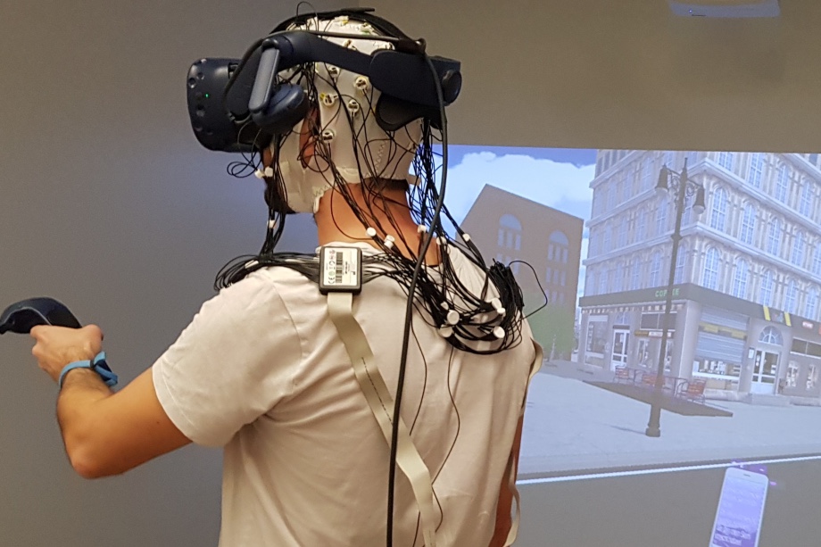
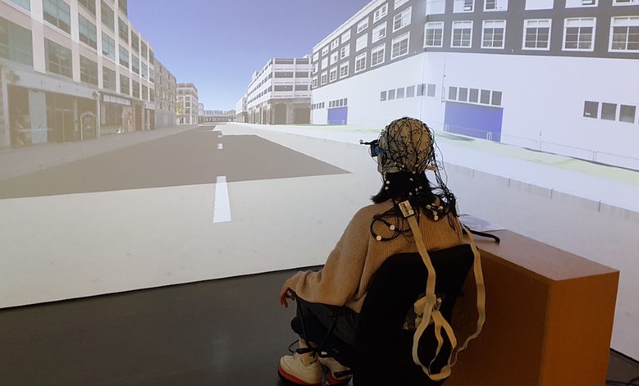
Title image: The world a test participant is experiencing wearing the HMD VR over an EEG cap is projected onto a large, screen-based CAVE VR system (© GIVA)
This interview was published by the Rīga Stradiņš University, Rīga, Latvia, on January 15, 2024.