Navigation auf uzh.ch
Navigation auf uzh.ch
Spectral analysis of satellite images is used e.g. in urban planning, forestry or water observation. Devis Tuia has proposed an algorithm that automatically finds the most optimal hyperspectral setting and combination of filters.
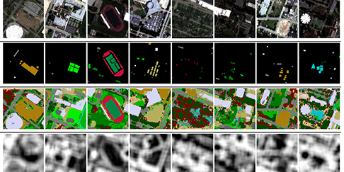
Hyperspectral sensors open up a wide range of applications, since they scan parts of the electromagnetic spectrum invisible to the naked eye. The analysis of hyperspectral aerial images allows to, e.g., determine the degree of drought in an agricultural zone or to find undamaged roads after a natural hasard. Depending on the purpose of the image analysis, one could want to focus on spatial characteristics that would draw attention to the object to be detected: such focusing can be obtained by applying local enhancements of the images, or filters. The problem is that there is an infinity of possible enhancements and one does not know which one to apply beforehand. In his publication Multiclass feature learning for hyperspectral image classification : Sparse and hierarchical solutions, Devis Tuia introduces an algorithm that automatically finds the best combination of spatial filters to solve problems of land use determination, thus easing the work of image analysts.
The French research council “Center National de la Recherche Scientifique” (CNRS) has now dedicated a news article to the highly praised publication: CNRS Artikel (french)