GIScience Reading Group
The GIScience Reading Group is the ultimate possibility for all of
us to broaden our horizons and engage into other fields of research
within Geographic Information Science. We therefore come together on
3 tuesday evenings (alternating to the colloquium) to discuss papers from
the broader GIScience community. For this term, papers were chosen by
the organizers of the reading group.
*Some guidence running Reading Group:
here.
*For password protected files approach Web Master. Current - Azimjon Sayidov.
FS 18: Waldo Tobler: The First Law of Geography
| Date | Time | Topic | Staff | Papers | Chair | |||||||||||||||||||||||||||||||||||||||||||||||||||||||||||||||||||||||||||||||||||||||||||||||||||||||||||||||||||||||||||||||||||||||||||||||||||||||||||||||||||||||||||||||||||||||||||||||||||||||||||||||||||||||||||||||||||||||||||||||||||||||||||||||||||||||||||||||||||||||||||||||||||||||||||||||||||||||||||||||||||||||||||||||||||||||||||||||||||||||||||||||||||||||||||||||||||||||||||||||||||||||||||||||||||||||||||||||||||||||||||||||||||||||||||||||||||||||||||||||||||||||||||||||||||||||||||||||||||||||||||||||||||||||||||||||||||||||||||||||||||||||||||||||||||||||||||||||||||||||||||||||||||||||||||||||||||||||||||||||||||||||||||||||||||||||||||||||||||||||||||||||||||||||||||||||||||||||||||||||||||||||||||||||||||||||||||||||||||||||||||||||||||||||||||||||||||||||||||||||||||||||||||||
|---|---|---|---|---|---|---|---|---|---|---|---|---|---|---|---|---|---|---|---|---|---|---|---|---|---|---|---|---|---|---|---|---|---|---|---|---|---|---|---|---|---|---|---|---|---|---|---|---|---|---|---|---|---|---|---|---|---|---|---|---|---|---|---|---|---|---|---|---|---|---|---|---|---|---|---|---|---|---|---|---|---|---|---|---|---|---|---|---|---|---|---|---|---|---|---|---|---|---|---|---|---|---|---|---|---|---|---|---|---|---|---|---|---|---|---|---|---|---|---|---|---|---|---|---|---|---|---|---|---|---|---|---|---|---|---|---|---|---|---|---|---|---|---|---|---|---|---|---|---|---|---|---|---|---|---|---|---|---|---|---|---|---|---|---|---|---|---|---|---|---|---|---|---|---|---|---|---|---|---|---|---|---|---|---|---|---|---|---|---|---|---|---|---|---|---|---|---|---|---|---|---|---|---|---|---|---|---|---|---|---|---|---|---|---|---|---|---|---|---|---|---|---|---|---|---|---|---|---|---|---|---|---|---|---|---|---|---|---|---|---|---|---|---|---|---|---|---|---|---|---|---|---|---|---|---|---|---|---|---|---|---|---|---|---|---|---|---|---|---|---|---|---|---|---|---|---|---|---|---|---|---|---|---|---|---|---|---|---|---|---|---|---|---|---|---|---|---|---|---|---|---|---|---|---|---|---|---|---|---|---|---|---|---|---|---|---|---|---|---|---|---|---|---|---|---|---|---|---|---|---|---|---|---|---|---|---|---|---|---|---|---|---|---|---|---|---|---|---|---|---|---|---|---|---|---|---|---|---|---|---|---|---|---|---|---|---|---|---|---|---|---|---|---|---|---|---|---|---|---|---|---|---|---|---|---|---|---|---|---|---|---|---|---|---|---|---|---|---|---|---|---|---|---|---|---|---|---|---|---|---|---|---|---|---|---|---|---|---|---|---|---|---|---|---|---|---|---|---|---|---|---|---|---|---|---|---|---|---|---|---|---|---|---|---|---|---|---|---|---|---|---|---|---|---|---|---|---|---|---|---|---|---|---|---|---|---|---|---|---|---|---|---|---|---|---|---|---|---|---|---|---|---|---|---|---|---|---|---|---|---|---|---|---|---|---|---|---|---|---|---|---|---|---|---|---|---|---|---|---|---|---|---|---|---|---|---|---|---|---|---|---|---|---|---|---|---|---|---|---|---|---|---|---|---|---|---|---|---|---|---|---|---|---|---|---|---|---|---|---|---|---|---|---|---|---|---|---|---|---|---|---|---|---|---|---|---|---|---|---|---|---|---|---|---|---|---|---|---|---|---|---|---|---|---|---|---|---|---|---|---|---|---|---|---|---|---|---|---|---|---|---|---|---|---|---|---|---|---|---|---|---|---|---|---|---|---|---|---|---|---|---|---|---|---|---|---|---|---|---|---|---|---|---|---|---|---|---|---|---|---|---|---|---|---|---|---|---|---|---|---|---|---|---|---|---|---|---|---|---|---|---|---|---|---|---|---|---|---|---|---|---|---|---|---|---|---|---|---|---|---|---|---|---|---|---|---|---|---|---|---|---|---|---|---|---|---|---|---|---|---|---|---|---|---|---|---|---|---|---|---|---|---|---|---|---|---|---|---|---|---|---|---|---|---|---|---|---|---|---|---|---|---|---|---|---|---|---|---|---|---|---|---|---|---|---|---|---|---|---|---|---|---|---|---|---|---|---|---|---|---|---|---|---|---|---|---|---|---|---|---|---|---|---|---|---|---|---|---|---|---|---|---|---|---|---|---|---|---|---|---|---|---|---|---|---|---|---|---|---|---|---|---|---|---|---|---|---|---|---|---|---|---|---|---|---|---|---|---|
| 3rd of April | 16:15 | The Origin | Sara Fabrikant | W. R. Tobler, (1970). A Computer Movie Simulating Urban Growth in the Detroit Region. | Azim & Julia | 17th of April | 16:15 | The Critiques | --- | Trevor J. Barnes, (2004). A Paper Related to Everything but More Related to Local Things. | Azim & Julia | May (tbd) | 16:15 | The Reply to Critiques | --- | W. R. Tobler, (2004). On the First Law of Geography: A Reply. | Azim & Julia | |||||||||||||||||||||||||||||||||||||||||||||||||||||||||||||||||||||||||||||||||||||||||||||||||||||||||||||||||||||||||||||||||||||||||||||||||||||||||||||||||||||||||||||||||||||||||||||||||||||||||||||||||||||||||||||||||||||||||||||||||||||||||||||||||||||||||||||||||||||||||||||||||||||||||||||||||||||||||||||||||||||||||||||||||||||||||||||||||||||||||||||||||||||||||||||||||||||||||||||||||||||||||||||||||||||||||||||||||||||||||||||||||||||||||||||||||||||||||||||||||||||||||||||||||||||||||||||||||||||||||||||||||||||||||||||||||||||||||||||||||||||||||||||||||||||||||||||||||||||||||||||||||||||||||||||||||||||||||||||||||||||||||||||||||||||||||||||||||||||||||||||||||||||||||||||||||||||||||||||||||||||||||||||||||||||||||||||||||||||||||||||||||||||||||||||||||||||||||||||||||

| Date | Time | Topic | Staff | Papers | Chair |
|---|---|---|---|---|---|
| 3rd of Oct | 16:15 | Terminology | --- | Eitzel, M. V. et al. (2017). Citizen Science Terminology Matters: Exploring Key Terms. Citizen Science: Theorey and Practice . | Kiran and Hoda | 14th of November | 16:15 | Challenges | Ross Purves | Comber, A. et al. (2016). Crowdsourcing: It Matters Who the Crowd Are. The Impacts of between Group Variations in Recording Land Cover. PLOS one. | Kiran and Hoda | 12th of December | 16:15 | Future Direction | --- | Newman, G. (2012). The future of citizen science: emerging technologies and shifting paradigms. Frontiers in Ecology and the Environment. | Kiran and Hoda |
FS 17: Metaphysical considerations of GIScience
| Date | Time | Topic | Staff | Papers | Chair |
|---|---|---|---|---|---|
| 21st of March | 16:15 | Philosophical perspectives | --- | Moon, K. & Blackman, D. (2014). A Guide to Understanding Social Science Research for Natural Scientists. Conservation Biology. | Oliver and Olga | 4th of April | 16:15 | Epistemology | --- | Sieber, R. & Haklay, M. (2015). The epistemology(s) of volunteered geographic information: a critique. Geography and Environment. | Oliver and Olga | 2nd of May | 16:15 | Ontology | --- | Agarwal, P. (2005). Ontological considerations in GIScience. International Journal of Geographical Information Science. | Oliver and Olga |
HS 16: Inferring meaning from quantitative data
*Slides of the Reading Group: here.*: links to paper (password protected)
FS 16: Data Quality
HS 15
| Date | Time | Topic | Staff | Papers | Chair |
|---|---|---|---|---|---|
| 7th of October | 16:15 | GIScience and Public Health | --- |
Gould, P., 2013. Sources of Error in a Map Series, or Science as a Socially Negotiated Enterprise. Cartographic Perspectives 30–48. |
Raha and Gianluca | 19th of October | 16:15 | GIScience and Public Health | --- |
Mennis, J., Mason, M.J., Cao, Y., 2013. Qualitative GIS and the Visualization of Narrative Activity Space Data. Int J Geogr Inf Sci 27, 267–291. |
Raha and Gianluca |
| 23 of November | 16:15 | GIScience and Public Health | --- |
Cummins, S., Curtis, S., Diez-Roux, A.V., Macintyre, S., 2007. Understanding and representing “place” in health research: A relational approach. Social Science & Medicine 65, 1825–1838. |
Raha and Gianluca |
*: links to paper (password protected)
FS 15
| Date | Time | Topic | Staff | Papers | Chair |
|---|---|---|---|---|---|
| 3rd of March | 16:00 | Big Data | Staff tbd |
Miller, H. J., & Goodchild, M. F. (2014). Data-driven geography. GeoJournal, 1-13 |
Maysam and Ismini | 21st of April | 16:00 | Navigation | Kai Florian |
M. Raubal and S. Winter. Enriching wayfinding instructions with local landmarks. In M. Egenhofer and D. Mark, editors, Geographic Information Science - Second International Conference GIScience 2002, pages 243–259, Berlin, 2002. Springer. LNCS 2478.* |
Maysam and Ismini |
| 28th of April | 16:00 | Visualanalytics | Arzu |
N. Andrienko and G. Andrienko. Designing Visual Analytics Methods for Massive Collections of Movement Data. In Cartographica, v.42 (2), Summer 2007, 117-138* |
Maysam and Ismini |
*: links to paper (password protected)
FS 14
| Date | Time | Topic | Staff | Papers | Chair |
|---|---|---|---|---|---|
| 25th of March | 16:00 | Space and Place | Staff tbd |
John Agnew (2011): Space and Place* |
Peter and Katja | 22nd of April | 16:00 | How to lie with maps | Staff tbd |
Handout* Zip-File with maps* (Additional) Monmonier M. (2005): Lying with Maps. In: Statistical Science, vol. 20:3, 215–222* |
Peter and Katja |
*: links to paper (password protected)
HS 13
| Date | Time | Topic | Staff | Papers | Additional Information |
|---|---|---|---|---|---|
| 17th of September | 16:15 | Spatial mental mappings and verbal communication | Kai-Florian/ Stephan Winter |
Winter (2012): How far is HAL-NAV?* Winter (2009): Spatial Intelligence: Ready for a Challenge?* Winter, Yu (2009): Intelligent Spatial Communication?* |
For the interested ones: Original paper on computers and intelligence by Turing from 1950* | 12th of November | 16:15 | GeoViz / Visualizing trajectories | Arzu | Andrienko et al - Space, time and visual analytics (2010)* | tbd |
| 10th of December | 16:15 | Attitudes and participation in wind energy planning | Ross | Simao et al. (2009): Web based GIS for collaborative planning and public participation: An application to the strategic planning of wind farm sites.* | tba |
*: links to paper (password protected)
FS 13
| Date | Time | Topic | Chair | Presentation | Staff | Papers | Download | |
|---|---|---|---|---|---|---|---|---|
| 19th of March | 16:15 | Language and Space | George and Ali | Flurina | Ross |
- "Landscape in language, An introduction" Mark et al., 2011 |
paper* |
16th of April | 16:15 | Historical GIS / Digital Humanities | Ali | Curdin | --- | - "Quantitative Analysis of Culture Using Millions of Digitized Books" Michel et al., 2011 |
paper* |
*: links to paper (password protected)
HS 12
| Date | Time | Topic | Chair | Presentation | Staff | Papers | Download | Additional Information |
|---|---|---|---|---|---|---|---|---|
| 9.10.2012 | 16:00 | GIS and Sports | Sara M. & Flurina | Sara M. | Patrick Laube |
- Gudmundsson A , Thomas Wolle (2010): Towards Automated Football Analysis: Algorithms and Data Structures. - Goldsberry, K. (2012): CourtVision: New Visual and Spatial Analytics for the NBA. |
paper* paper* |
16.10.2012 | 16:00 | Critical GIS & digital humanities | Sara M. & Flurina | Flurina | Ross Purves | Sheppard, Eric (2004): Knowledge Production through Critical GIS: Genealogy and Prospects. Cartographica, 40 (4), 5-21 | text* |
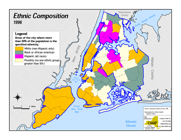
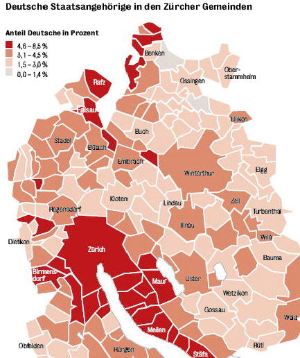
map illustrating an article named “Ethnic Politics and the Changing Face of New York” in the Gotham Gazette map originally published in Tagesanzeiger on 29.11.2008 illustrating an article named “The many Germans and us” |
| 30.10.2012 | 16:00 | Big Data | Flurina | tba | Robert Weibel | Boyd, Danah & Crawford, Kate (2011): Six provocations for big data. Paper presented at the Symposium on the Dynamics of Internet and Society at the Oxford Internet Institute, September 21, 2011. | text* | Programme as PDF |
| 11.12.2012 | 16:15 | GIS & Cognitive Science | Sara M. | Arzu Cöltekin | Arzu Cöltekin | -Montello, D. R. (2009). Cognitive research in GIScience: Recent achievements and future prospects. Geography Compass, 3(5), 1824–1840. |
paper* |
Programme as PDF |
*: links to publisher homepage
FS 12
| Date | Time | Topic | Chair | Presentation | Staff | Papers | Download | Summary |
|---|---|---|---|---|---|---|---|---|
| 03.04.2012 | 16:00 | Movement | Georgios | Christian | Patrick | -Mobility, Data Mining and Privacy: A Vision of Convergence, Giannotti F., Pedreschi D., 2008. -Computational Movement Analysis, Gudmundsson et al., 2012. -Migration and stopover in a small pelagic seabird, the Manx shearwater Puffinus puffinus: insights from machine learning, Guilford et al., 2009. |
text* text* text* |
Sara. M Patrick Flurina |
30.04.2012 | 16:00 | Geographic Information Retrieval | Curdin | Ramya | Ross | -Geographic Information Retrieval, Jones CB., Purves RS., 2008. -The design and implementation of SPIRIT, Purves RS. Et al., 2007. -A machine learning approach for resolving place references in Text, Martins B. et al., 2010. |
text* text* text* |
Pia Ross Stefano |
| 22.05.2012 | 16:00 | Geographic Decision Making | Kenan | Paul | Sara. F | -Geovisual analytics for spatial decision support: Setting the research agenda, Andrienko G. et al., 2007. -Personalized multi-criteria decision strategies in location-based decision support, Rinner C., Raubal M., 2004. -Integrating geographical information systems and multiple criteria decision-making methods, Jankowski P., 1995. |
text* text* text* |
Ali Damien Marco |
*: password-protected
HS 11
| Date | Time | Paper | Session Chair | Download | Summary |
|---|---|---|---|---|---|
| 04.10.2011 | 16:00 | From Computer Cartography to Spatial Visualization a new Cartogram Algorithm, Dorling D. 1993. | tba | text* | tba | 25.10.2011 | 16:00 | Gis-based multicriteria decision analysis - a survey of the literature. Malczewski J. 2006. | tba | text* | tba |
| 01.11.2011 | 16:00 | Crime analysis through spatial areal aggregated density patterns. Phillips, P. and Lee, I. 2011. | tba | text* | tba |
| 15.11.2011 | 16:00 | Propagating radial waves of travel cost in a grid, Tomlin, D. 2010. | Jan | text* | George |
| 22.11.2011 | 16:00 | Do mountains exist? Towards an ontology of landforms, Smith B. & Mark D. M. 2004. | Curdin | text* | Curdin |
*: password-protected
FS 11
| Date | Time | Paper | Session Chair | Download | Summary |
|---|---|---|---|---|---|
| 22.03.2011 | 16:00 | Loose-coupling a cellular automaton model and GIS: long-term urban growth prediction for San Francisco and Washington/Baltimore, Clarke K. and Gaydos L. 1998. | Paul | text* | Georgie | 05.04.2011 | 16:00 | What Maps Mean to People: Denotation, Connotation, and Geographic Visualization in Land-Use Debates. Couclelis H. and Gottsegen J. 1997. | Paul | text* | Kenan |
| 19.04.2011 | 16:00 | Modelling vague places with knowledge from the Web. Jones C. B., Purves R. S., Clough P. D. and Joho H. 2008. | Ramya | text* | Marco |
| 10.05.2011 | 16:00 | Distinguishing technology from biology: a critical review of the use of GPS telemetry data in ecology, Hebblewhite M. and Haydon D.T. 2010. | Kenan | text* | Christian |
| 07.06.2011 | 16:00 | Ontological considerations in GIScience, Agarwal P. 2004. | Jan | text* | Curdin |
*: password-protected
HS 10
| Date | Time | Paper | Session Chair | Download | Summary |
|---|---|---|---|---|---|
| 02.11.2010 | 17:00 | Next-Generation Digital Earth, Vespucci Initiative, 2008. | Arzu | text* | Kenan |
| 16.11.2010 | 17:00 | Improving interaction with virtual globes through spatial thinking: helping users ask "why?", Schöning et al., 2008. | Somayeh | text* | Stefano |
| 30.11.2010 | 17:00 | Continuous nearest neighbor search, Tao et al., 2002. | Pia | text* | Ramya |
| 07.12.2010 | 17:00 | How good is volunteered geographical information? A comparative study of OpenStreetMap and Ordnance Survey, Haklay et al., 2010. | Jan | text* | Curdin |
| 11.01.2011 | 17:00 | Genocide and GIScience: Integrating Personal Narratives and GIScience to Study Human Rights, Madden et al., 2009. | Anna-Katharina | text* | Marco |
*: password-protected
FS 10
| Date | Time | Paper | Session Chair | Download | Summary |
|---|---|---|---|---|---|
| 16.03.2010 | 17:00 | Geographic information systems and science: today and tomorrow. Goodchild MF. 2009 | Anna-Katharina L. | text* | Marco Salvini |
| 30.03.2010 | 17:00 | "Dynamic collectives and their collective dynamics. Galton, A. 2005". | Somayeh Dodge | text* | Paul Crease |
| 20.04.2010 | 17:00 | Geographic information retrieval in a mobile environment: evaluating the needs of mobile individuals. D. Mountain, A. MacFarlane. 2007 | Pia Bereuter | text* | Stefano De Sabbata |
| 04.05.2010 | 17:00 | Using co-occurrence models for placename disambiguation. Overell S, Rüger S. 2008. | Martin Tomko | text* | Ramya |
| 11.05.2010 | 17:00 | Applications of Signal Detection Theory to Geographic Information Science. Griffin AL, Bell S. 2009. | Jan Wilkening | text* | Ross Purves |
| 01.06.2010 | 17:00 | Defining a Digital Earth system. Grossner KE, Goodchild MF, Clarke KC. 2008. | Arzu Çöltekin | text* | Kenan Bektas |
*: password-protected
HS 09
| Date | Time | Paper | Session Chair | Download | Summary |
|---|---|---|---|---|---|
| 6.10.2009 | 17:00 | The Architecture of Complexity. Simon, 1962. | Anna-Katharina Lautenschütz | text* | Paul Crease |
| 20.10.2009 | 17:00 | "Simplest Paths": Automated Route Selection for Navigation. Duckham & Kulik, 2003. | Somayeh Dodge | text* | Ramya Venkateswaran |
| 3.11.2009 | 17:00 | Real-time, continuous level of detail rendering of height fields. Lindstrom et al., 1996. | Arzu Cöltekin | text* | Kenan Bektas |
| 17.11.2009 | 17:00 | Quantitative Limits to Qualitative Engagements: GIS, Its Critics, and the Philosophical Divide . Leszczynski, 2009. | Jan Wilkening | text* | Marco Salvini |
| 1.12.2009 | 17:00 | Formalization Matters: Critical GIS and Ontology Research. Schuurman, 2000. | Pia Bereuter | text* | Stefano De Sabbata |
*: password-protected
FS 09
| Date | Time | Paper | Session Chair | Download | Summary |
|---|---|---|---|---|---|
| 3.3.2009 | 17:00 | Modelling accessibility using space-time prism concepts within geographical information systems. Miller, 1991 | Jan Wilkening | text* | Stefano De Sabbata |
| 17.3.2009 | 17:00 | The nature of geographic knowledge. Golledge, 2002 | Patrick Lüscher | text* | Ramya Venkateswaran |
| 31.3.2009 | 17:00 | Naive Geography. Mark and Egenhofer, 1995 | Ralph Straumann | text* | Paul Crease |
| 28.4.2009 | 17:00 | Dynamic 3D maps as visual interfaces for spatio-temporal data. Doellner et al. 2000 | Martin Tomko | text* | Kenan Bektas |
| 12.5.2009 | 17:00 | Understanding Geographic Space. Mackaness, 2007 | Somayeh Dodge | text* | Marco Salvini |
| 26.5.2009 | 17:00 | Evidence of Hierarchies in Cognitive Maps Hirtle & Jonides, 1985 | Anna-Katharina Lautenschütz | text* | Pia Bereuter |
*: password-protected
HS 08
| Date | Time | Paper(s) | Session Chair | Download |
|---|---|---|---|---|
| 23.09.2008 | 17:00 | Wickens Pearce, M. (2008): Framing the Days: Place and Narrative in Cartography. In: Cartography and Geographic Information Science, 35(1), 17–32. | Jan Wilkening | |
| 07.10.2008 | 17:00 | Raubal, M. and Egenhofer, M. (1998): Comparing the complexity of wayfinding tasks in built environments. In: Environment & Planning B, 25(6), 895–913. | Pia Bereuter | |
| 21.10.2008 | 17:00 | Klippel, A., Worboys, M. and Duckham, M.(2007): Identifying factors of geographic event conceptualisation. In: International Journal of Geographical Information Science, 22(2), 183–204. | Frank Ostermann | |
| 18.11.2008 | 17:00 | Goodchild, M. F. (2008): Spatial Accuracy 2.0. Proceeding of the 8th international symposium on spatial accuracy assessment in natural resources and environmental sciences. | Felix Hebeler | |
| 02.12.2008 | 17:00 | Chevriaux, Y., Saux, E., Claramunt, C. (2005): A Landform-based Approach for the Representation of Terrain Silhouettes. ACM GIS'05 - 13th ACM International Symposium on Advances in Geographic Information Systems. | Stefano | |
| 16.12.2008 | 17:00 | Bian, L. (2007): Object-Oriented Representation of Environmental Phenomena: Is Everything Best Represented as an Object? In: Annals of the Association of American Geographers, 97(2), 267–281 | Somayeh Dodge |
FS 08
| Date | Time | Paper(s) | Session Chair | Download | |
|---|---|---|---|---|---|
| 04.03.2008 | 17:00 | Evans, A. J., Kingston, R. and Carver, S. (2004): Democratic input into the nuclear waste disposal problem: The influence of geographical data on decision making examined through a Web-based GIS. In: Journal of Geographical Systems, 6(2), 117–132. | Anna-Katharina Lautenschütz | ||
| 18.03.2008 | 17:00 | Sengupta, R. and Sieber, R. (2007): Geospatial Agents, Agents Everywhere. In: Transactions in GIS, 11(4), 483–506. Bennet, D. A. and Tang, W. (2006): Modelling adaptive, spatially aware, and mobile agents: Elk migration in Yellowstone. In: International Journal of Geographical Information Science, 20(9), 1039–1066. |
Frank Ostermann | PDF |
|
| 08.04.2008 | 17:00 | Ren, F. and Kwan, M.-P. (2007): Geovisualization of Human Hybrid Activity-Travel Patterns. In: Transactions in GIS, 11(5), 721–744 | Somayeh Dodge | ||
| 22.04.2008 | 17:00 | Harris, R. (2006): Between Hot Air and Hot Spot: Placing Location Based Services within GI Science. In: Transactions in GIS, 10(1), 1–4. Simon, R., Fröhlich, P. and Anegg, H. (2007): Enabling Spatially Aware Mobile Applications. In: Transactions in GIS, 11(5), 783–794. |
Thomas Grossmann | PDF |
|
| 06.05.2008 | 17:00 | Stelder, D. (2005): Where do Cities form? A Geographical Agglomeration Model for Europe. In: Journal of Regional Science, 45(4), 657–679. | Ralph Straumann | PDF Erratum |
|
| 20.05.2008 | 17:00 | Robertson, C., Nelson, T. A., Boots, B. and Wulder, M. A. (2007): STAMP: spatial-temporal analysis of moving polygons. In: Journal of Geographical Systems, 9(3), 207–227. | Jan Wilkening |
HS 07
| Date | Time | Paper | Session Chair | Download | Summary |
|---|---|---|---|---|---|
| 16.10.2007 | 17:00 | Sprague D S, Iwasaki N, Takahashi S (2007): Measuring rice paddy persistence spanning a century with Japan's oldest topographic maps. IJGIS, 21(1), 83-95. | Arzu Çöltekin | DOI | Summary by Anna-Katharina Lautenschütz |
| 6.11.2007 | 17:00 | Reuter H I, Nelson A, Jarvis A (2007): An evaluation of void-filling interpolation methods for SRTM data. IJGIS, 21(9), 983-1008. | Ross Purves | DOI | Summary by Felix Hebeler |
| 20.11.2007 | 17:00 | Hornsby K (2001): Temporal zooming. Transactions in GIS, 5(3), 255-272. | I volunteer! | DOI | Summary by Somayeh Dodge |
| 4.12.2007 | 17:00 | Murgante B, Las Casas G, Danese M (2007): The use of spatial statistics to analyze the periurban belt. Proceedings of the 10th AGILE International Conference on Geographic Information Science, 8.-11.5.2007, Aalborg, Denmark | Tumasch Reichenbacher | Summary by Anna-Katharina Lautenschütz | |
| 18.12.2007 | 17:00 | Nelhans G (2007): Citations within the GI literature - Theoretical works or good examples?. Proceedings of the 10th AGILE International Conference on Geographic Information Science, 8.-11.5.2007, Aalborg, Denmark | Dirk Burghardt | I volunteer! |
SS 07
| This term's textbook is: Peter Fisher (ed., 2007): Classics from IJGIS. Twenty years of the International Journal of Geographical Information Science and Systems'. CRC Press, Boca Raton FL. | |||||
| Date | Time | Paper | Session Chair | Download | Summary |
|---|---|---|---|---|---|
| 3.4.2007 | 17:00 | Modelling accessibility using space-time prism concepts within GISs. Miller, 1991 | Ralph Straumann | Hardcopy | Frank Ostermann |
| 17.4.2007 | 17:00 | Integrating GISs and multiple criteria decision-making methods. Jankowski, 1995 | Ross Purves | Summary by Patrick Lüscher | |
| 15.5.2007 | 17:00 | Qualitative spatial reasoning: Cardinal directions as an example. Frank, 1996 | Arzu Çöltekin | Summary by Stefan Steiniger | |
| 29.5.2007 | 17:00 | Geographical categories: An ontological investigation. Smith and Mark, 2001 | none | Summary by Anna-Katharina Lautenschütz | |
| 19.6.2007 | 17:00 | Extending GIS-based visual analysis: the concept of visualscapes. Llobera, 2003 | looking for a volunteer | Summary by Tumasch Reichenbacher | |
* Classics from IJGIS contains the original article - which we offer for download here - along with a current comment on the article and the developments in the field at hand by the author(s). Since these comments only appear in the text book we can't offer them for download - please pick your copy in the Q-library.
WS 06/07
| Date | Time | Paper | Session Chair | Download | Summary |
|---|---|---|---|---|---|
| 31.10.2006 | 17:00 | Fisher P.F. (1999): Models of uncertainty in spatial data. In: Longley P.A., Goodchild M.F., Maguire D.J. and Rhind D.W. (eds.): Geographical Information Systems. John Wiley & Sons, New York, 191-205 | Frank Ostermann | Hardcopy in 25J92 | |
| 14.11.2006 | 17:00 | Fisher P.F. (2000): Sorites paradox and vague geographies. Fuzzy Sets and
Systems, 113, 7-18 Goldstein L. (2000): How to boil a live frog. Analysis, 60, 171-177 |
Ross Purves | ||
| 28.11.2006 | 17:00 | Fisher P.F. (2000): Fuzzy Modelling, in: Openshaw S. and Abrahart R.J. (eds): GeoComputation. Taylor & Francis, London, 161-186 | Frank Ostermann | Hardcopy in 25J92 | |
| 12.12.2006 | 17:00 | Burrough P.A. (2000): High-resolution landform classification using fuzzy k-means. Fuzzy Sets and Systems, 113, 37-52 | Stephan Steiniger | ||
Merry Christmas! http://commons.wikimedia.org |
|||||
| 16.01.2007 | 17:00 | Excerpt (13 pages) of Burrough P.A. and McDonnell R.A.(1998): Fuzzy Sets and Fuzzy Geographical Objects. In: Principles of Geographical Information Systems., 265-291 | tbd | Hardcopy in 25J92 | |
| Supplement: Graphical overview of fuzzy set combinations | |||||
| 30.01.2007 | 17:00 | MacEachren A.M., Robinson A., Hopper S., Gardner S., Murray R., Gahegan M. and Hetzler E. (2005): Visualizing Geospatial Information Uncertainty: What We Know and What We Need to Know. Cartography and Geographic Information Science, 32, 139-160 | tbd | nya |
SS 05
| Definition of 'boundaries' according to the Stanford Encyclopedia of Philosophy | |||||
| Date | Time | Paper | Session Chair | Download | Summary |
|---|---|---|---|---|---|
| 21.6.2005 | 16:00 | William Walters, 2002: Mapping Schengenland: Denaturalizing the Border. Environ.& Planning D: Society & Space 20(5): 561-80 | Urs-Jakob Rüetschi | Hardcopy | |
WS 04/05
| Date | Time | Paper | Session Chair | Download | Summary |
|---|---|---|---|---|---|
| 26. 10. 2004 | 16:00 |
Daniel Z. Sui (2004): Tobler's First Law of Geography: A Big Idea for a Small World? Annals of the Association of American Geographers, 94(2), pp. 267-277. Waldo Tobler (2004): On the First Law of Geography: A Reply. Annals of the Association of American Geographers, 94(2), pp. 304-310. Access the other AAAG papers of this forum. |
Ross Purves | ||
| 09. 11. 2004 | 16:00 | Reginald G. Golledge (2002): The nature of Geographic Knowledge. Annals of the Association of American Geographers, 92(1), pp. 1-14. | Patrick Laube | ||
| 23. 11. 2004 | 16:00 | Simon A. Levin (1992): The Problem of Pattern and Scale in Ecology: The Robert MacArthur Award Lecture. Ecology, Vol. 73, No. 6, 1947-1967. | Felix Hebeler | (4.4MB!) |
|
| 07. 12. 2004 | 16:00 | Subject: Space Syntax
1. Bafna, Sonit: Space Syntax. A Brief Introduction to Its Logic and Analytical Techniques. Pages 17-29 in Environment and Behavior, vol 35, no 1, January 2003. 2. Jiang, Bin et al.: An integration of space syntax into GIS for modelling urban spaces. Pages 161-171 in Journal of Applied Earth Observation and Geoinformation, vol 2, no 3/4, 2000. |
Urs-Jakob Rüetschi | Bafna Jiang |
|
| 18. 01. 2005 | 16:00 | Stan Franklin and Art Graesser (1996): Is it an Agent, or just a Program?: A Taxonomy for Autonomous Agents. Proceedings of the Third International Workshop on Agent Theories, Architectures, and Languages, Springer-Verlag. | David Caduff | ||
| 01. 03. 2005 | 16:00 | W. Loibl and T. Toetzer (2003): Modeling growth and densification processes in suburban regions - simulation of landscape transition with spatial agents. Environmental Modelling & Software, Vol. 18, Issue 6, p. 553-563. | Stefan Steiniger |
SS 04
| Date | Time | Paper | Session Chair | Download | Summary |
|---|---|---|---|---|---|
| 09. 03. 2004 | 16:00 | George A. Miller (1956): The Magical Number Seven, Plus or Minus Two: Some Limits on Our Capacity for Processing Information. The Psychological Review (63)1956, 81-97. | Syed Awase Khirni | html | |
| 06. 04. 2004 | 16:00 | P. Lagacherie, J.M. Robbez-Masson, N. Nguyen-The, J.P. Barthes (2001): Mapping of reference area representativity using a mathematical soilscape distance, Geoderma (101)2001, 105-118. | Felix Hebeler | ||
| 20. 04. 2004 | 16:00 | D. Guo, D.J. Peuquet, M. Gahegan (2003): ICEAGE: Interactive Clustering and Exploration of Large and High-Dimensional Geodata. GeoInformatica 7:3, 229-253 | Patrick Laube | ||
| 04. 05. 2004 | 16:00 | M.A. Rodriguez, M.J. Egenhofer (2004): Comparing geospatial entity classes: an asymmetric and context-dependent similarity measure. INT. J. GEOGRAPHICAL INFORMATION SCIENCE, Vol. 18, No.3, April May 2004, 229-256 | Syed Awase Khirni | ||
| 25. 05. 2004 | 16:00 | Jerome E. Dobson and Peter F. Fisher (2003): Geoslavery. IEEE Technology and Society Magazine , Vol. 22, No. 1, 47-52. | Dirk Burghardt | ||
| 08. 06. 2004 | 16:00 | Corona, B., Winter, S. (2001): Approaches to an Ontology for Pedestrian Navigation Services. Technical Report, Institute for Geoinformation, Technical University Vienna, Austria. | David Caduff | ||
| 22. 06. 2004 | 11:30 | Jiang, B., Harrie, L.(2004): Selection of Streets from a Network using self-organizing Maps | Moritz Neun |
WS 03/04
| Date | Time | Paper | Session Chair | Download | Summary |
|---|---|---|---|---|---|
| 28. 10. 2003 | 11:30 | Goodchild, M. F. (1992): Geographical Information Science. Int. J. Geographical Information Systems, vol. 6, no. 1, 31-45. | Patrick Laube | ||
| 11. 11. 2003 | 16:00 | Worboys, M. F. (1996): Metrics and topologies for geographic space. Proc. 7th Intl. Symp. Spatial Data Handling, Delft, Netherlands. | Urs-Jakob Rüetschi | ||
| 09. 12. 2003 | 16:00 | Curry, M.R. (1998): Digital Places: Living with Geographic Information Systems, The reshaping of geographic practice (Chap. 5). Routeledge, London. | Alistair Edwardes | - | |
| 13. 01. 2004 | 11:30 | Mark, David M. (2002). Geographic Information Science: Defining the Field. In Duckham, M., Goddchild, M.F., Worboys, M.F. (Eds.): Foundations of Geographic Information Science, pages 3-18, Taylor & Francis, London and New York. | Sabine Timpf | - | |
| 27. 01. 2004 | 16:00 | Michael F. Goodchild (2001): Models of Scale and Scales of Modelling (incl. foreword to the volume by Michael Batty). In Nicholas J. Tate, Peter M. Atkinson (Eds): Modelling Scale in Geographical Information Science, pages 3-10, Wiley. | Dani Isenegger | - | |
| 17. 02. 2004 | 16:00 | Rykiel, E.J. (1996): Testing ecological models: the meaning of validation. Ecological Modelling (90)1996, 229-244. | Ross Purves |